Virginia Elevation Map
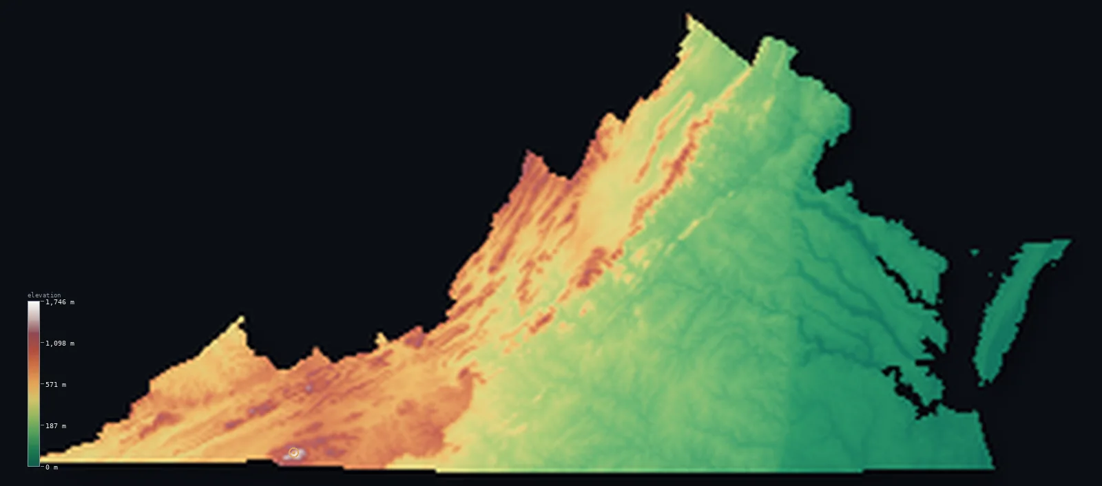
Virginia’s highest point is Mount Rogers at 5,728 ft (1,746 m); its lowest is Atlantic Ocean at 0 ft (0 m); the mean elevation is 1,010 ft (308 m).
- Highest point📚
- 5,728 ft1,746 m
- Mount Rogers.
- Lowest point📚
- 0 ft0 m
- Atlantic Ocean.
- Mean elevation⚙
- 1,010 ft308 m
- Computed from the GLO-30 surface model.
- Median elevation⚙
- 604 ft184 m
- Half of Virginia lies below this height.
- Elevation range📚
- 5,728 ft1,746 m
- From 0 m to Mount Rogers's 1746 m.
- Above 1,000 m (3,281 ft)⚙
- 2%
- The state's main highlands.
- Official area📚
- 42,775 mi²110,787 km²
- Virginia.
Virginia at a glance
Mount Rogers is capped by a rare Ice Age relic spruce-fir forest, more like Canada than the South.
source ↗Chesapeake Bay, the largest estuary in the United States, nearly cuts off Virginia's Eastern Shore.
source ↗The Shenandoah Valley is one of the most fertile and historic valleys in the eastern US.
source ↗Virginia falls from 1,746 m in the Blue Ridge to sea level at the coast in under 500 km.
source ↗Natural Bridge, a 66 m limestone arch, was once surveyed by a young George Washington.
source ↗
Elevation profile of Virginia
The largest share of land, 51%, falls in the 0–200 m band, and 74% of the territory lies below 500 m (1,640 ft).
- below 500 m (1,640 ft)74%
- 500–1,000 m25%
- 1,000–2,000 m2%
Highest and lowest points
The highest point of Virginia, Mount Rogers, 1,746 m, in the Blue Ridge of the state's southwest - its summit cloaked in a rare high-elevation spruce-fir forest, a cool island left behind by the Ice Age.
source ↗Highest peaks of Virginia
| Peak | Elevation | Range | Note |
|---|---|---|---|
| Mount Rogers↗ | 5,728 ft1,746 m | Blue Ridge Mountains | Highest point of Virginia, with spruce-fir forest. |
| Whitetop Mountain↗ | 5,525 ft1,684 m | Blue Ridge Mountains | The second-highest peak in Virginia, beside Mount Rogers. |
| Pine Mountain↗ | 4,593 ft1,400 m | Appalachian Plateau | A high ridge of far southwestern Virginia. |
| Elliott Knob↗ | 4,462 ft1,360 m | Ridge and Valley | The highest peak of the Ridge and Valley region. |
| Hawksbill Mountain↗ | 4,052 ft1,235 m | Blue Ridge Mountains | The high point of Shenandoah National Park. |
Terrain regions of Virginia
Mount Rogers is capped by a rare Ice Age relic spruce-fir forest, more like Canada than the South. ↗
The Appalachian mountains and valleys
↗Western Virginia is Appalachian country - the Blue Ridge carrying Mount Rogers (1,746 m), the long parallel ridges and fertile valleys of the Ridge and Valley i
The Piedmont
↗Central Virginia is the rolling Piedmont, sloping east from the Blue Ridge to the fall line, where rivers drop toward tidewater. This is the historic heart of t
The Tidewater and coast
↗Eastern Virginia is the flat Tidewater coastal plain, cut by the broad tidal rivers and the great estuary of Chesapeake Bay, which nearly splits the region and
The Appalachian mountains and valleys
the westWestern Virginia is Appalachian country - the Blue Ridge carrying Mount Rogers (1,746 m), the long parallel ridges and fertile valleys of the Ridge and Valley including the Shenandoah Valley, and the rugged Appalachian Plateau of the far southwest coalfields. This is the state's high, forested backbone.
The Piedmont
the centreCentral Virginia is the rolling Piedmont, sloping east from the Blue Ridge to the fall line, where rivers drop toward tidewater. This is the historic heart of the state, its low hills holding Richmond, Charlottesville and the horse country.
The Tidewater and coast
the eastEastern Virginia is the flat Tidewater coastal plain, cut by the broad tidal rivers and the great estuary of Chesapeake Bay, which nearly splits the region and holds the Eastern Shore peninsula. The land lies barely above sea level, meeting the Atlantic at zero elevation.
City elevations in Virginia
| City | Population | Elevation |
|---|---|---|
| Virginia Beach | 454,808 | 13 ft4 m |
| Richmond | 226,610 | 226 ft69 m |
| Arlington | 207,627 | 279 ft85 m |
| Roanoke | 100,011 | 945 ft288 m |
| Suffolk | 88,161 | 56 ft17 m |
| Lynchburg | 79,812 | 653 ft199 m |
| Harrisonburg | 52,538 | 1,335 ft407 m |
| Charlottesville | 46,597 | 469 ft143 m |
| Danville | 42,082 | 499 ft152 m |
| Fredericksburg | 28,118 | 69 ft21 m |
Elevation sampled at each city centre from the Copernicus GLO-30 model. Cities and population from GeoNames (CC-BY 4.0).
Virginia in comparison
Virginia's terrain rises 5,728 ft (1,746 m) from sea level to Mount Rogers — about 20% of the height of Mount Everest, the world's highest point at 29,032 ft (8,849 m).
Frequently asked questions
What is the highest point in Virginia?
- Mount Rogers, 5,728 ft (1,746 m).
What is the average elevation of Virginia?
- About 290 m according to the USGS; this page also reports the area-weighted mean computed from the Copernicus GLO-30 model, 1,010 ft (308 m).
What is the lowest point in Virginia?
- Atlantic Ocean, 0 ft (0 m).
Mount Rogers is capped by a rare Ice Age relic spruce-fir forest?
- Mount Rogers is capped by a rare Ice Age relic spruce-fir forest, more like Canada than the South.
Where is the highest ground in Virginia?
- Western Virginia is Appalachian country - the Blue Ridge carrying Mount Rogers (1,746 m), the long parallel ridges and fertile valleys of the Ridge and Valley including the Shenandoah Valley, and the
Is this a topographic, relief, contour, or elevation map of Virginia?
- They describe the same thing - terrain height. This page renders Virginia's actual elevation surface in interactive 3D (a relief or topographic view) and reports the statistics computed from it; a contour map shows the same data as lines of equal height.
About this map
The terrain is rendered from the Copernicus GLO-30 digital elevation model (ESA), masked to the US-VA boundary from geoBoundaries (gbOpen). Elevation statistics are computed directly from the model; peak names and researched facts are sourced and cited. See the methodology for the full pipeline.
This map renders 104,841 km² across 8 landmasses of Virginia. 3 smaller outlying parts — 2 km² in total — lie beyond the area shown here. Area statistics above count the full territory.
Our area-weighted mean, computed from the Copernicus GLO-30 model, is 1,010 ft (308 m); the figure commonly cited elsewhere is 951 ft (290 m) (U.S. Geological Survey). Virginia's mean elevation is about 290 m; the page reports the area-weighted figure computed from the Copernicus GLO-30 model.
Surveyed national figures: official area · high point.
Rendered from Copernicus GLO-30 (ESA, 2021 release), boundaries from geoBoundaries. Generated 2026-07-14.