West Virginia Elevation Map
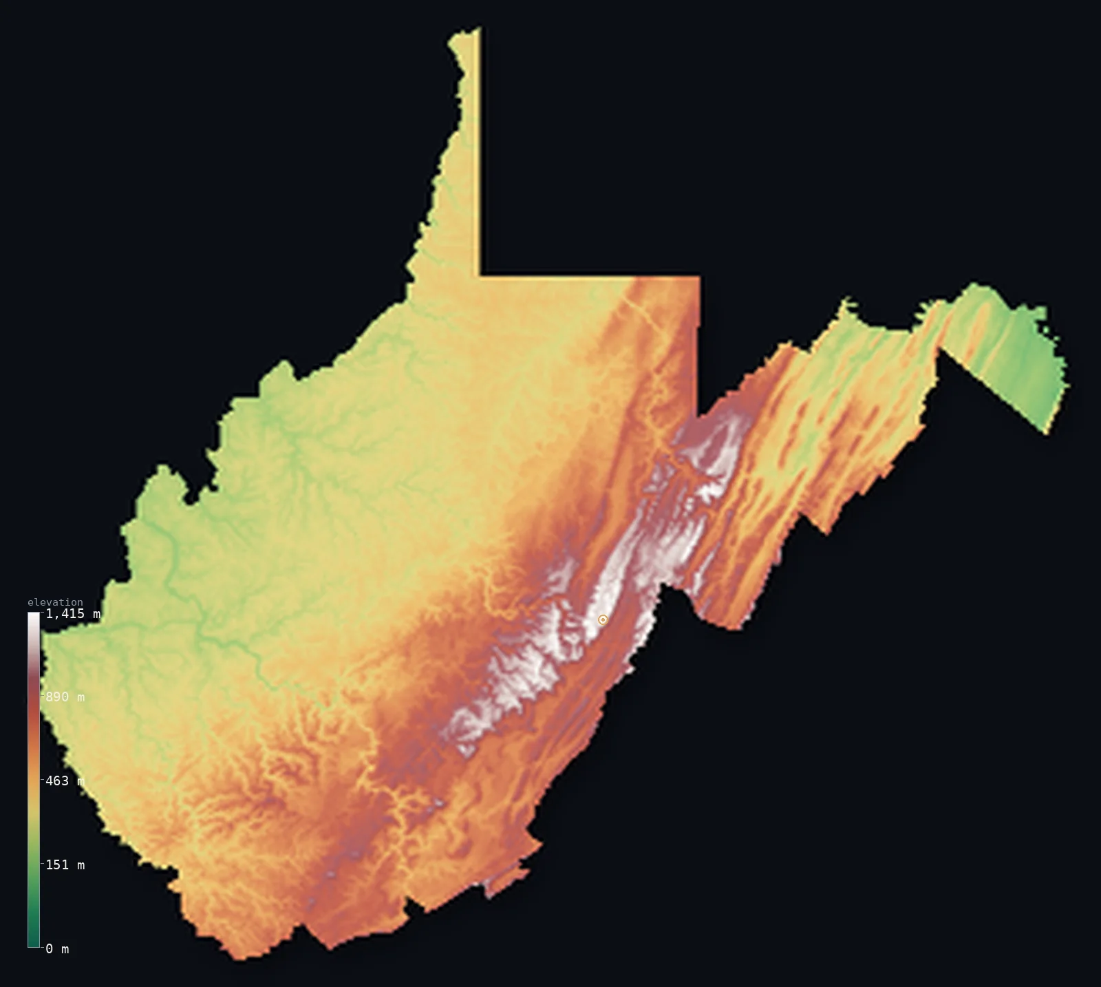
West Virginia’s highest point is Spruce Knob at 4,862 ft (1,482 m); its lowest is Potomac River at 240 ft (73 m); the mean elevation is 1,699 ft (518 m).
- Highest point📚
- 4,862 ft1,482 m
- Spruce Knob.
- Lowest point📚
- 240 ft73 m
- Potomac River.
- Mean elevation⚙
- 1,699 ft518 m
- Computed from the GLO-30 surface model.
- Median elevation⚙
- 1,430 ft436 m
- Half of West Virginia lies below this height.
- Elevation range📚
- 4,623 ft1,409 m
- From 73 m to Spruce Knob's 1482 m.
- Above 1,000 m (3,281 ft)⚙
- 5%
- The state's higher ground.
- Official area📚
- 24,230 mi²62,756 km²
- West Virginia.
West Virginia at a glance
West Virginia is the most mountainous state east of the Mississippi, with the highest mean elevation in the eastern US.
source ↗The red spruce atop Spruce Knob grow flagged and one-sided from the relentless west wind.
source ↗The state has essentially no natural flat land - it is folded and dissected end to end.
source ↗The eastern Continental Divide runs through West Virginia's Allegheny highlands.
source ↗West Virginia's mean elevation is the highest of any state east of the Mississippi River.
source ↗
Elevation profile of West Virginia
The largest share of land, 23%, falls in the 300–400 m band, and 56% of the territory lies below 500 m (1,640 ft).
- below 500 m (1,640 ft)56%
- 500–1,000 m38%
- 1,000–2,000 m5%
Highest and lowest points
The highest point of West Virginia, Spruce Knob, 1,482 m, the summit of Spruce Mountain in the Allegheny Highlands - a wind-raked, one-sided ridge whose red spruce trees grow flagged and bent by the constant westerly gales.
source ↗Highest peaks of West Virginia
| Peak | Elevation | Range | Note |
|---|---|---|---|
| Spruce Knob↗ | 4,862 ft1,482 m | Allegheny Mountains | Highest point of West Virginia, wind-swept summit. |
| Bald Knob↗ | 4,823 ft1,470 m | Allegheny Mountains | The second-highest peak in the state. |
| Thorny Flat↗ | 4,810 ft1,466 m | Allegheny Mountains | A high point of the Allegheny highlands. |
| Snowshoe Mountain↗ | 4,800 ft1,463 m | Allegheny Mountains | A high ridge developed as a ski resort. |
| Back Allegheny Mountain↗ | 4,757 ft1,450 m | Allegheny Mountains | A high forested ridge of the eastern highlands. |
Terrain regions of West Virginia
West Virginia is the most mountainous state east of the Mississippi, with the highest mean elevation in the eastern US. ↗
The Allegheny Highlands
↗Eastern West Virginia rises into the Allegheny Mountains, the highest and most rugged part of the state, where Spruce Knob (1,482 m) tops Spruce Mountain. This
The Allegheny Plateau
↗Most of West Virginia is the Allegheny Plateau, a deeply dissected upland where rivers have carved a maze of steep, narrow valleys and forested ridges. There is
The Eastern Panhandle and river valleys
↗In the east, the Ridge and Valley reaches into the Eastern Panhandle, where the Potomac and its branches cut through the ridges and drop to the state's lowest p
The Allegheny Highlands
the eastEastern West Virginia rises into the Allegheny Mountains, the highest and most rugged part of the state, where Spruce Knob (1,482 m) tops Spruce Mountain. This is a high, cool country of spruce forest, open 'balds' and the eastern Continental Divide, with the state's most dramatic relief.
The Allegheny Plateau
the centre and westMost of West Virginia is the Allegheny Plateau, a deeply dissected upland where rivers have carved a maze of steep, narrow valleys and forested ridges. There is barely a flat acre - the whole state is famously mountainous, its hills folded and cut into an endless rugged grain.
The Eastern Panhandle and river valleys
the panhandles and riversIn the east, the Ridge and Valley reaches into the Eastern Panhandle, where the Potomac and its branches cut through the ridges and drop to the state's lowest point at 73 m. The Ohio River forms the western border in its own broad valley.
City elevations in West Virginia
| City | Population | Elevation |
|---|---|---|
| Huntington | 48,638 | 571 ft174 m |
| Charleston | 46,838 | 617 ft188 m |
| Parkersburg | 30,991 | 617 ft188 m |
| Morgantown | 30,708 | 896 ft273 m |
| Wheeling | 27,648 | 669 ft204 m |
| Cumberland | 20,130 | 633 ft193 m |
| Weirton Heights | 19,450 | 1,191 ft363 m |
| Martinsburg | 17,700 | 456 ft139 m |
| Beckley | 17,056 | 2,415 ft736 m |
| Clarksburg | 16,152 | 1,004 ft306 m |
Elevation sampled at each city centre from the Copernicus GLO-30 model. Cities and population from GeoNames (CC-BY 4.0).
West Virginia in comparison
West Virginia's terrain rises 4,623 ft (1,409 m) from Potomac River (240 ft (73 m)) to Spruce Knob — about 16% of the height of Mount Everest, the world's highest point at 29,032 ft (8,849 m).
Frequently asked questions
What is the highest point in West Virginia?
- Spruce Knob, 4,862 ft (1,482 m).
What is the average elevation of West Virginia?
- About 460 m according to the USGS; this page also reports the area-weighted mean computed from the Copernicus GLO-30 model, 1,699 ft (518 m).
What is the lowest point in West Virginia?
- Potomac River, 240 ft (73 m).
West Virginia is the most mountainous state east of the Mississippi?
- West Virginia is the most mountainous state east of the Mississippi, with the highest mean elevation in the eastern US.
Where is the highest ground in West Virginia?
- Eastern West Virginia rises into the Allegheny Mountains, the highest and most rugged part of the state, where Spruce Knob (1,482 m) tops Spruce Mountain. This is a high, cool country of spruce forest
Is this a topographic, relief, contour, or elevation map of West Virginia?
- They describe the same thing - terrain height. This page renders West Virginia's actual elevation surface in interactive 3D (a relief or topographic view) and reports the statistics computed from it; a contour map shows the same data as lines of equal height.
About this map
The terrain is rendered from the Copernicus GLO-30 digital elevation model (ESA), masked to the US-WV boundary from geoBoundaries (gbOpen). Elevation statistics are computed directly from the model; peak names and researched facts are sourced and cited. See the methodology for the full pipeline.
Our area-weighted mean, computed from the Copernicus GLO-30 model, is 1,699 ft (518 m); the figure commonly cited elsewhere is 1,509 ft (460 m) (U.S. Geological Survey). West Virginia's mean elevation is about 460 m; the page reports the area-weighted figure computed from the Copernicus GLO-30 model.
Surveyed national figures: official area · high point.
Rendered from Copernicus GLO-30 (ESA, 2021 release), boundaries from geoBoundaries. Generated 2026-07-14.