Pennsylvania Elevation Map
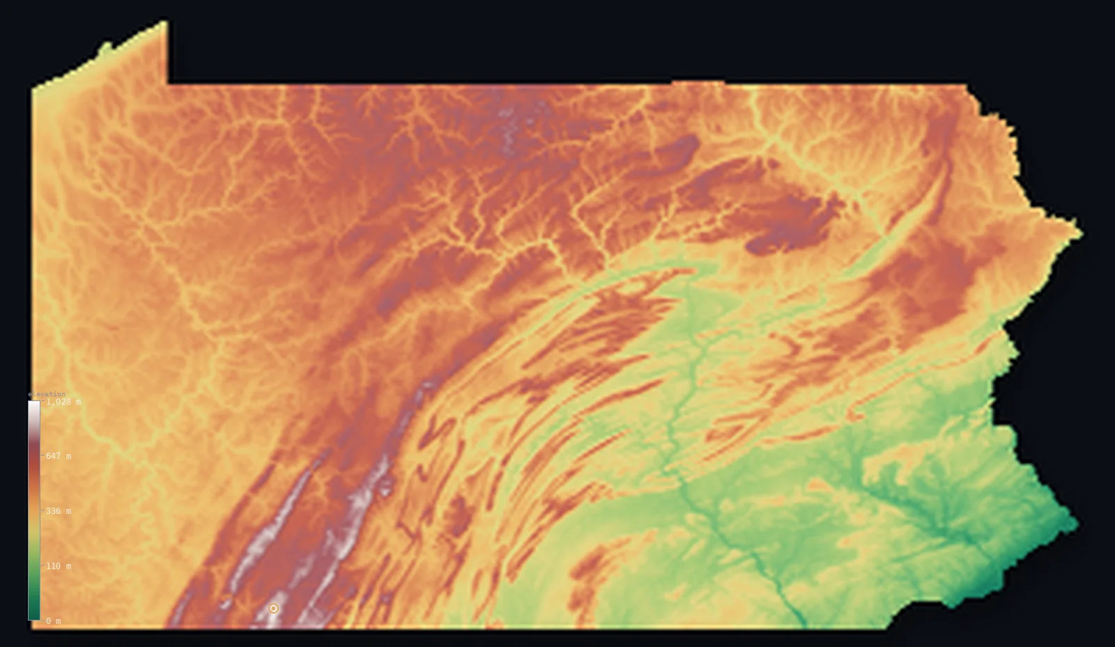
Pennsylvania’s highest point is Mount Davis at 3,212 ft (979 m); its lowest is Delaware River at 0 ft (0 m); the mean elevation is 1,270 ft (387 m).
- Highest point📚
- 3,212 ft979 m
- Mount Davis.
- Lowest point📚
- 0 ft0 m
- Delaware River.
- Mean elevation⚙
- 1,270 ft387 m
- Computed from the GLO-30 surface model.
- Median elevation⚙
- 1,273 ft388 m
- Half of Pennsylvania lies below this height.
- Elevation range📚
- 3,212 ft979 m
- From 0 m to Mount Davis's 979 m.
- Official area📚
- 46,054 mi²119,280 km²
- Pennsylvania.
Pennsylvania at a glance
Pennsylvania's high point, Mount Davis, is a broad plateau swell rather than a distinct peak.
source ↗The Ridge and Valley's parallel ridges are the eroded roots of ancient folded mountains.
source ↗The Susquehanna River cuts straight across mountain ridges through dramatic water gaps.
source ↗Pennsylvania's whole relief spans less than 1,000 m, from Mount Davis to sea level at Philadelphia.
source ↗The state sits atop some of the richest anthracite coal deposits in the world.
source ↗
Elevation profile of Pennsylvania
The largest share of land, 24%, falls in the 300–400 m band, and 75% of the territory lies below 500 m (1,640 ft).
- below 500 m (1,640 ft)75%
- 500–1,000 m25%
Highest and lowest points
Highest peaks of Pennsylvania
| Peak | Elevation | Range | Note |
|---|---|---|---|
| Mount Davis↗ | 3,212 ft979 m | Allegheny Plateau | Highest point of Pennsylvania, a broad plateau rise. |
| Blue Knob↗ | 2,999 ft914 m | Allegheny Plateau | The second-highest point in Pennsylvania. |
| Big Savage Mountain↗ | 2,900 ft884 m | Allegheny Plateau | A high ridge of the southwestern plateau. |
| Bald Eagle Mountain↗ | 2,201 ft671 m | Ridge and Valley | A long ridge of the central Ridge and Valley. |
| Camelback Mountain↗ | 2,201 ft671 m | Pocono Mountains | A well-known summit of the Poconos in the northeast. |
Terrain regions of Pennsylvania
Pennsylvania's high point, Mount Davis, is a broad plateau swell rather than a distinct peak. ↗
The Allegheny Plateau
↗Western and northern Pennsylvania is the Allegheny Plateau, a broad, deeply dissected upland of forested hills and steep valleys - not sharp peaks but a high ta
The Ridge and Valley
↗Central Pennsylvania is classic Ridge and Valley country - long, parallel, wave-like ridges and fertile limestone valleys running northeast to southwest, formed
The Piedmont and coastal edge
↗Southeastern Pennsylvania descends into the rolling Piedmont farmland around Lancaster and the fall line, dropping to the low Atlantic coastal edge along the De
The Allegheny Plateau
the west and northWestern and northern Pennsylvania is the Allegheny Plateau, a broad, deeply dissected upland of forested hills and steep valleys - not sharp peaks but a high tableland carved by rivers. Its southwestern corner rises to Mount Davis (979 m), the state's highest ground, and the plateau holds the coal and gas that built the state's industry.
The Ridge and Valley
the centreCentral Pennsylvania is classic Ridge and Valley country - long, parallel, wave-like ridges and fertile limestone valleys running northeast to southwest, formed by ancient folding of the crust. The Susquehanna River cuts dramatically across the grain of these ridges through a series of water gaps.
The Piedmont and coastal edge
the southeastSoutheastern Pennsylvania descends into the rolling Piedmont farmland around Lancaster and the fall line, dropping to the low Atlantic coastal edge along the Delaware River at Philadelphia - the state's lowest point at sea level, and its most densely settled corner.
City elevations in Pennsylvania
| City | Population | Elevation |
|---|---|---|
| Philadelphia | 1,573,916 | 62 ft19 m |
| Pittsburgh | 304,391 | 807 ft246 m |
| Allentown | 120,207 | 344 ft105 m |
| Erie | 99,475 | 659 ft201 m |
| Reading | 87,879 | 276 ft84 m |
| Scranton | 77,118 | 758 ft231 m |
| Lancaster | 59,339 | 374 ft114 m |
| Levittown | 52,983 | 33 ft10 m |
| Harrisburg | 50,183 | 338 ft103 m |
| Altoona | 45,344 | 1,171 ft357 m |
Elevation sampled at each city centre from the Copernicus GLO-30 model. Cities and population from GeoNames (CC-BY 4.0).
Pennsylvania in comparison
Pennsylvania's terrain rises 3,212 ft (979 m) from sea level to Mount Davis — about 11% of the height of Mount Everest, the world's highest point at 29,032 ft (8,849 m).
Frequently asked questions
What is the highest point in Pennsylvania?
- Mount Davis, 3,212 ft (979 m).
What is the average elevation of Pennsylvania?
- About 340 m according to the USGS; this page also reports the area-weighted mean computed from the Copernicus GLO-30 model, 1,270 ft (387 m).
What is the lowest point in Pennsylvania?
- Delaware River, 0 ft (0 m).
Pennsylvania's high point?
- Pennsylvania's high point, Mount Davis, is a broad plateau swell rather than a distinct peak.
Where is the highest ground in Pennsylvania?
- Western and northern Pennsylvania is the Allegheny Plateau, a broad, deeply dissected upland of forested hills and steep valleys - not sharp peaks but a high tableland carved by rivers. Its southweste
Is this a topographic, relief, contour, or elevation map of Pennsylvania?
- They describe the same thing - terrain height. This page renders Pennsylvania's actual elevation surface in interactive 3D (a relief or topographic view) and reports the statistics computed from it; a contour map shows the same data as lines of equal height.
About this map
The terrain is rendered from the Copernicus GLO-30 digital elevation model (ESA), masked to the US-PA boundary from geoBoundaries (gbOpen). Elevation statistics are computed directly from the model; peak names and researched facts are sourced and cited. See the methodology for the full pipeline.
Our area-weighted mean, computed from the Copernicus GLO-30 model, is 1,270 ft (387 m); the figure commonly cited elsewhere is 1,115 ft (340 m) (U.S. Geological Survey). Pennsylvania's mean elevation is about 340 m; the page reports the area-weighted figure computed from the Copernicus GLO-30 model.
Surveyed national figures: official area · high point.
Rendered from Copernicus GLO-30 (ESA, 2021 release), boundaries from geoBoundaries. Generated 2026-07-14.