New Jersey Elevation Map
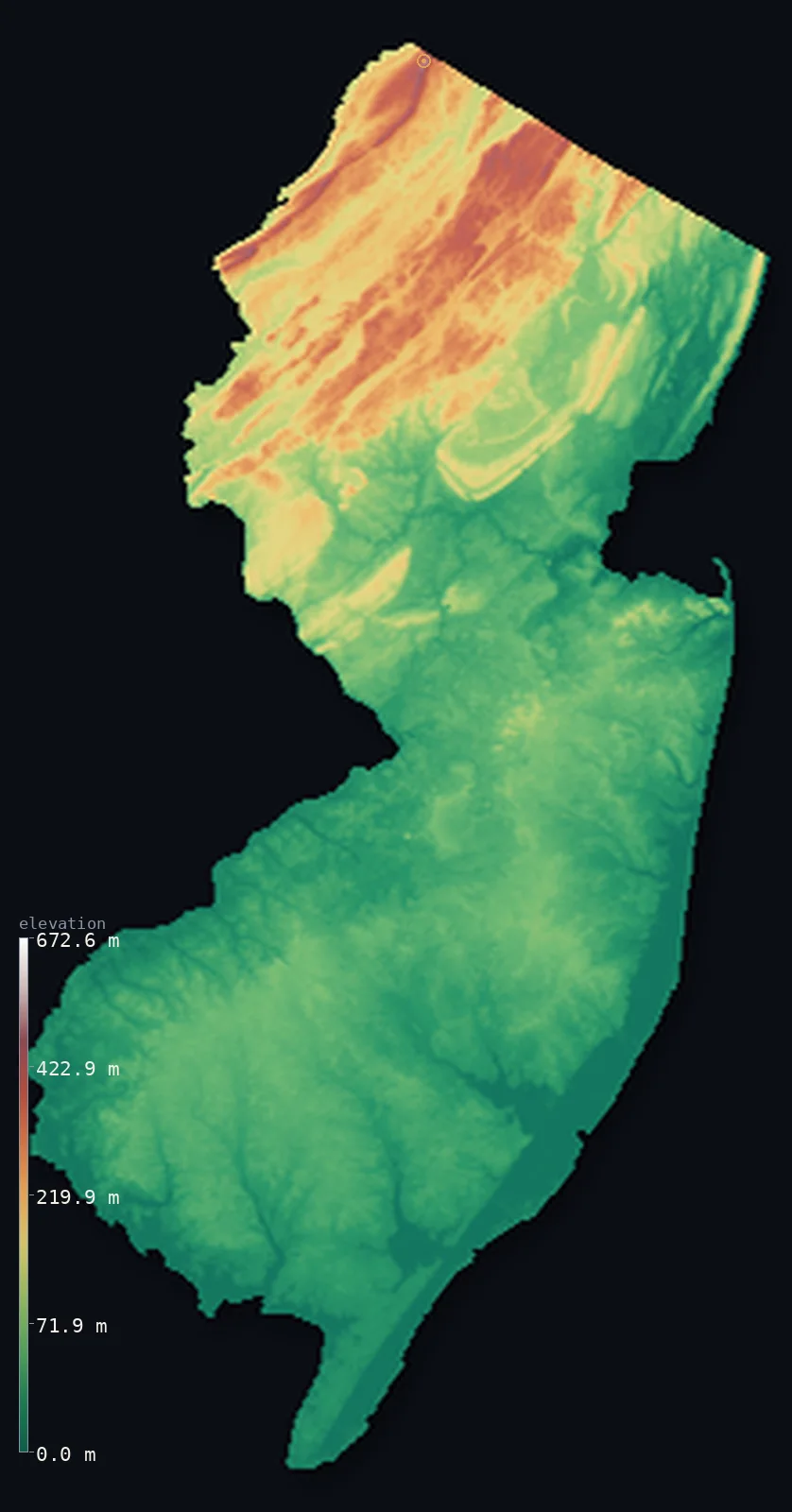
New Jersey’s highest point is High Point at 1,804 ft (550 m); its lowest is Atlantic Ocean at 0 ft (0 m); the mean elevation is 240 ft (73.3 m).
- Highest point📚
- 1,804 ft550 m
- High Point.
- Lowest point📚
- 0 ft0 m
- Atlantic Ocean.
- Mean elevation⚙
- 240 ft73.3 m
- Computed from the GLO-30 surface model.
- Median elevation⚙
- 112 ft34 m
- Half of New Jersey lies below this height.
- Elevation range📚
- 1,804 ft550 m
- From 0 m to High Point's 550 m.
- Above 50 m (164 ft)⚙
- 35%
- The state's higher ground.
- Official area📚
- 8,722 mi²22,591 km²
- New Jersey.
New Jersey at a glance
New Jersey's High Point is crowned by a 67 m obelisk, lifting a monument above the Appalachian ridge.
source ↗The Pine Barrens is a vast, sandy pine forest sitting atop one of the largest aquifers in the region.
source ↗The Palisades along the Hudson are dramatic cliffs of ancient hardened magma.
source ↗New Jersey is the most densely populated state, yet more than half of it is farmland and forest.
source ↗The Delaware Water Gap, where the river cuts through the Kittatinny ridge, is a dramatic mountain pass.
source ↗
Elevation profile of New Jersey
The largest share of land, 63%, falls in the 0–50 m band, and >99% of the territory lies below 500 m (1,640 ft).
- 0–10 m (0–33 ft)16%
- 10–50 m (33–164 ft)49%
- above 50 m (164 ft)35%
Highest and lowest points
The highest point of New Jersey, aptly named High Point, 550 m, at the state's far northern tip in the Kittatinny Mountains - crowned by a 67 m obelisk that lifts a war memorial above the ridge of the Appalachians.
source ↗Highest peaks of New Jersey
| Peak | Elevation | Range | Note |
|---|---|---|---|
| High Point↗ | 1,804 ft550 m | Kittatinny Mountains | Highest point of New Jersey, topped by an obelisk. |
| Kittatinny Ridge highpoint↗ | 1,706 ft520 m | Kittatinny Mountains | The long ridge running southwest from High Point. |
| Sunrise Mountain↗ | 1,542 ft470 m | Kittatinny Mountains | A high point on the Kittatinny ridge. |
| Wawayanda highpoint↗ | 1,509 ft460 m | New Jersey Highlands | A high point of the northern Highlands. |
| Bearfort Mountain↗ | 1,411 ft430 m | New Jersey Highlands | A high ridge of the northern Highlands. |
Terrain regions of New Jersey
New Jersey's High Point is crowned by a 67 m obelisk, lifting a monument above the Appalachian ridge. ↗
The northern mountains and Highlands
↗Northwestern New Jersey is the state's high country - the long Kittatinny Ridge, part of the Appalachians, holding High Point (550 m), and the rugged, lake-stre
The Piedmont and central lowlands
↗Central New Jersey is the rolling Piedmont, with traprock ridges like the Watchung Mountains and the Palisades along the Hudson, descending to the low, populous
The coastal plain and Shore
↗More than half of New Jersey is flat Atlantic Coastal Plain - the Pine Barrens of sandy pine forest, the farmland of the south, and the long barrier-island Jers
The northern mountains and Highlands
the northwestNorthwestern New Jersey is the state's high country - the long Kittatinny Ridge, part of the Appalachians, holding High Point (550 m), and the rugged, lake-strewn New Jersey Highlands of old, hard rock. This is the state's most rugged and forested region, cut by the Delaware Water Gap.
The Piedmont and central lowlands
the centreCentral New Jersey is the rolling Piedmont, with traprock ridges like the Watchung Mountains and the Palisades along the Hudson, descending to the low, populous corridor between New York and Philadelphia - the busy heart of the most densely populated state.
The coastal plain and Shore
the southMore than half of New Jersey is flat Atlantic Coastal Plain - the Pine Barrens of sandy pine forest, the farmland of the south, and the long barrier-island Jersey Shore, sloping to the Atlantic and Delaware Bay at sea level.
City elevations in New Jersey
| City | Population | Elevation |
|---|---|---|
| Newark | 281,944 | 43 ft13 m |
| Paterson | 147,754 | 95 ft29 m |
| Edison | 102,548 | 92 ft28 m |
| Trenton | 89,620 | 69 ft21 m |
| Toms River | 88,791 | 30 ft9 m |
| Camden | 76,119 | 10 ft3 m |
| Middletown | 65,490 | 141 ft43 m |
| Vineland | 60,818 | 115 ft35 m |
| Morningside Heights | 55,929 | 184 ft56 m |
| Jackson | 54,856 | 131 ft40 m |
Elevation sampled at each city centre from the Copernicus GLO-30 model. Cities and population from GeoNames (CC-BY 4.0).
New Jersey in comparison
New Jersey's terrain rises 1,804 ft (550 m) from sea level to High Point — about 6% of the height of Mount Everest, the world's highest point at 29,032 ft (8,849 m).
Frequently asked questions
What is the highest point in New Jersey?
- High Point, 1,804 ft (550 m).
What is the average elevation of New Jersey?
- About 80 m according to the USGS; this page also reports the area-weighted mean computed from the Copernicus GLO-30 model, 240 ft (73.3 m).
What is the lowest point in New Jersey?
- Atlantic Ocean, 0 ft (0 m).
New Jersey's High Point is crowned by a 67 m obelisk?
- New Jersey's High Point is crowned by a 67 m obelisk, lifting a monument above the Appalachian ridge.
Where is the highest ground in New Jersey?
- Northwestern New Jersey is the state's high country - the long Kittatinny Ridge, part of the Appalachians, holding High Point (550 m), and the rugged, lake-strewn New Jersey Highlands of old, hard roc
Is this a topographic, relief, contour, or elevation map of New Jersey?
- They describe the same thing - terrain height. This page renders New Jersey's actual elevation surface in interactive 3D (a relief or topographic view) and reports the statistics computed from it; a contour map shows the same data as lines of equal height.
About this map
The terrain is rendered from the Copernicus GLO-30 digital elevation model (ESA), masked to the US-NJ boundary from geoBoundaries (gbOpen). Elevation statistics are computed directly from the model; peak names and researched facts are sourced and cited. See the methodology for the full pipeline.
Our area-weighted mean, computed from the Copernicus GLO-30 model, is 240 ft (73.3 m); the figure commonly cited elsewhere is 262 ft (80 m) (U.S. Geological Survey). New Jersey's mean elevation is about 80 m; the page reports the area-weighted figure computed from the Copernicus GLO-30 model.
Surveyed national figures: official area · high point.
Rendered from Copernicus GLO-30 (ESA, 2021 release), boundaries from geoBoundaries. Generated 2026-07-14.