New York Elevation Map
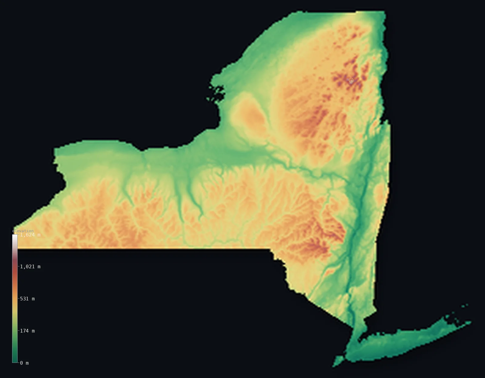
New York’s highest point is Mount Marcy at 5,344 ft (1,629 m); its lowest is Atlantic Ocean at 0 ft (0 m); the mean elevation is 1,125 ft (343 m).
- Highest point📚
- 5,344 ft1,629 m
- Mount Marcy.
- Lowest point📚
- 0 ft0 m
- Atlantic Ocean.
- Mean elevation⚙
- 1,125 ft343 m
- Computed from the GLO-30 surface model.
- Median elevation⚙
- 1,142 ft348 m
- Half of New York lies below this height.
- Elevation range📚
- 5,344 ft1,629 m
- From 0 m to Mount Marcy's 1629 m.
- Above 1,000 m (3,281 ft)⚙
- <1%
- The state's main highlands.
- Official area📚
- 54,555 mi²141,297 km²
- New York.
New York at a glance
The Adirondack Mountains are still slowly rising, unlike most of the ancient Appalachians.
source ↗The Adirondack Park is the largest protected area in the contiguous United States.
source ↗New York ranges from 1,629 m in the High Peaks down to sea level on Long Island.
source ↗The Adirondack Park is the largest publicly protected area in the contiguous United States, bigger than Yellowstone, Yosemite, Grand Canyon and the Everglades combined.
source ↗New York's Adirondacks are geologically young at the surface but built from some of the oldest rock in North America, over a billion years old.
source ↗
Elevation profile of New York
The largest share of land, 33%, falls in the 400–600 m band, and 76% of the territory lies below 500 m (1,640 ft).
- below 500 m (1,640 ft)76%
- 500–1,000 m24%
- 1,000–2,000 m<1%
Highest and lowest points
Highest peaks of New York
| Peak | Elevation | Range | Note |
|---|---|---|---|
| Mount Marcy↗ | 5,344 ft1,629 m | Adirondack Mountains | Highest point of New York, in the High Peaks. |
| Algonquin Peak↗ | 5,115 ft1,559 m | Adirondack Mountains | The second-highest peak in the state. |
| Mount Haystack↗ | 4,961 ft1,512 m | Adirondack Mountains | A remote High Peak beside Marcy. |
| Whiteface Mountain↗ | 4,865 ft1,483 m | Adirondack Mountains | A prominent peak above Lake Placid. |
| Slide Mountain↗ | 4,180 ft1,274 m | Catskill Mountains | The highest peak of the Catskills to the south. |
Terrain regions of New York
The Adirondack Mountains are still slowly rising, unlike most of the ancient Appalachians. ↗
The Adirondack Mountains
↗Northern New York is filled by the Adirondacks, a great circular dome of ancient rock uplifted into a wild highland of forests, lakes and rounded peaks. Its Hig
The Appalachian Plateau and Catskills
↗Southern New York is the dissected Appalachian Plateau, a broad upland cut by deep valleys and the Finger Lakes, rising in the southeast to the Catskill Mountai
The lowlands and the coast
↗New York's lowlands frame the highlands: the Great Lakes plain along Lake Ontario and Erie, the broad Hudson-Mohawk valley cutting through the state, and, at th
The Adirondack Mountains
the northNorthern New York is filled by the Adirondacks, a great circular dome of ancient rock uplifted into a wild highland of forests, lakes and rounded peaks. Its High Peaks region carries Mount Marcy (1,629 m), the state's summit, and the Adirondacks - unusually - are still slowly rising today.
The Appalachian Plateau and Catskills
the southSouthern New York is the dissected Appalachian Plateau, a broad upland cut by deep valleys and the Finger Lakes, rising in the southeast to the Catskill Mountains above the Hudson. This is hill-and-valley country, from the Southern Tier to the Hudson Highlands.
The lowlands and the coast
the valleys and coastNew York's lowlands frame the highlands: the Great Lakes plain along Lake Ontario and Erie, the broad Hudson-Mohawk valley cutting through the state, and, at the far southeast, the flat coastal plain of Long Island reaching into the Atlantic at sea level.
City elevations in New York
| City | Population | Elevation |
|---|---|---|
| New York City | 8,804,190 | 118 ft36 m |
| Buffalo | 258,071 | 604 ft184 m |
| Rochester | 209,802 | 515 ft157 m |
| Syracuse | 144,142 | 407 ft124 m |
| Albany | 101,228 | 148 ft45 m |
| Utica | 61,100 | 463 ft141 m |
| Brentwood | 60,664 | 82 ft25 m |
| Binghamton | 46,032 | 869 ft265 m |
| Kiryas Joel | 32,954 | 719 ft219 m |
| Ithaca | 30,788 | 427 ft130 m |
Elevation sampled at each city centre from the Copernicus GLO-30 model. Cities and population from GeoNames (CC-BY 4.0).
New York in comparison
New York's terrain rises 5,344 ft (1,629 m) from sea level to Mount Marcy — about 18% of the height of Mount Everest, the world's highest point at 29,032 ft (8,849 m).
Frequently asked questions
What is the highest point in New York?
- Mount Marcy, 5,344 ft (1,629 m).
What is the average elevation of New York?
- About 300 m according to the USGS; this page also reports the area-weighted mean computed from the Copernicus GLO-30 model, 1,125 ft (343 m).
What is the lowest point in New York?
- Atlantic Ocean, 0 ft (0 m).
The Adirondack Mountains are still slowly rising, unlike most of the ancient Appalachians?
- The Adirondack Mountains are still slowly rising, unlike most of the ancient Appalachians.
Where is the highest ground in New York?
- Northern New York is filled by the Adirondacks, a great circular dome of ancient rock uplifted into a wild highland of forests, lakes and rounded peaks. Its High Peaks region carries Mount Marcy (1,62
Is this a topographic, relief, contour, or elevation map of New York?
- They describe the same thing - terrain height. This page renders New York's actual elevation surface in interactive 3D (a relief or topographic view) and reports the statistics computed from it; a contour map shows the same data as lines of equal height.
About this map
The terrain is rendered from the Copernicus GLO-30 digital elevation model (ESA), masked to the US-NY boundary from geoBoundaries (gbOpen). Elevation statistics are computed directly from the model; peak names and researched facts are sourced and cited. See the methodology for the full pipeline.
Our area-weighted mean, computed from the Copernicus GLO-30 model, is 1,125 ft (343 m); the figure commonly cited elsewhere is 984 ft (300 m) (U.S. Geological Survey). New York's mean elevation is about 300 m; the page reports the area-weighted figure computed from the Copernicus GLO-30 model.
Surveyed national figures: official area · high point.
Rendered from Copernicus GLO-30 (ESA, 2021 release), boundaries from geoBoundaries. Generated 2026-07-13.