Connecticut Elevation Map
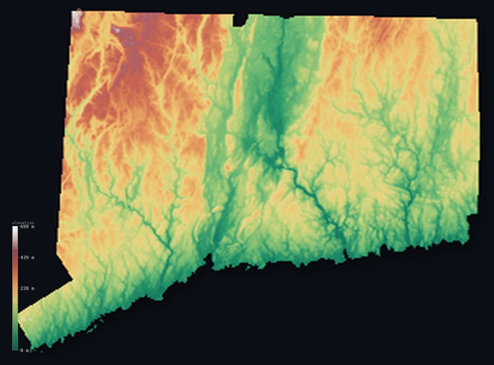
Connecticut’s highest point is Mount Frissell (south slope) at 2,379 ft (725 m); its lowest is Long Island Sound at 0 ft (0 m); the mean elevation is 489 ft (149 m).
- Highest point📚
- 2,379 ft725 m
- Mount Frissell (south slope).
- Lowest point📚
- 0 ft0 m
- Long Island Sound.
- Mean elevation⚙
- 489 ft149 m
- Computed from the GLO-30 surface model.
- Median elevation⚙
- 430 ft131 m
- Half of Connecticut lies below this height.
- Elevation range📚
- 2,379 ft725 m
- From 0 m to Mount Frissell (south slope)'s 725 m.
- Official area📚
- 5,543 mi²14,357 km²
- Connecticut.
Connecticut at a glance
Connecticut's high point is a spot on a hillside - the actual summit of Mount Frissell is in Massachusetts.
source ↗Connecticut's central valley is lined with dramatic traprock ridges of ancient hardened lava.
source ↗The state faces Long Island Sound, a sheltered estuary rather than the open Atlantic.
source ↗Connecticut is one of the smallest states, yet spans hills, valleys and coast.
source ↗The highest true summit standing wholly in Connecticut is Bear Mountain, not the state high point.
source ↗
Elevation profile of Connecticut
The largest share of land, 21%, falls in the 50–100 m band, and >99% of the territory lies below 500 m (1,640 ft).
- below 500 m (1,640 ft)>99%
- 500–1,000 m<1%
Highest and lowest points
The highest point of Connecticut, 725 m, is not a summit at all but a spot on the south slope of Mount Frissell - whose actual peak lies in Massachusetts - one of the few state high points that is a hillside rather than a mountaintop.
source ↗Mount Frissell (south slope) is a border summit: its peak lies just outside the generalized Connecticut boundary, so the highest fully in-territory land pixel in the model is 2,379 ft (725 m). The headline figure above is the surveyed elevation of the recognised national high point.
Highest peaks of Connecticut
| Peak | Elevation | Range | Note |
|---|---|---|---|
| Mount Frissell south slope↗ | 2,379 ft725 m | Taconic Mountains | Highest point of Connecticut - a slope, not a summit. |
| Bear Mountain↗ | 2,323 ft708 m | Taconic Mountains | The highest actual summit within Connecticut. |
| Round Mountain↗ | 2,303 ft702 m | Taconic Mountains | A high peak of the northwestern corner. |
| Gridley Mountain↗ | 2,100 ft640 m | Taconic Mountains | A high point of the Litchfield Hills. |
| Bald Peak↗ | 2,100 ft640 m | Litchfield Hills | A high point of the western uplands. |
Terrain regions of Connecticut
Connecticut's high point is a spot on a hillside - the actual summit of Mount Frissell is in Massachusetts. ↗
The western highlands
↗Northwestern Connecticut is the state's highest country - the Litchfield Hills and the edge of the Taconic Mountains, where the high point sits on the south slo
The central valley and eastern hills
↗The middle of Connecticut is split by the broad Connecticut River valley running to Long Island Sound, flanked by traprock ridges. East and west of it rise the
The coastal lowlands
↗Southern Connecticut slopes to the shore of Long Island Sound - a low, densely settled coastal lowland of harbors, river mouths and the state's largest cities,
The western highlands
the northwestNorthwestern Connecticut is the state's highest country - the Litchfield Hills and the edge of the Taconic Mountains, where the high point sits on the south slope of Mount Frissell (725 m) at the three-state corner. This is rolling, forested upland, the most rugged part of a mostly gentle state.
The central valley and eastern hills
the centre and eastThe middle of Connecticut is split by the broad Connecticut River valley running to Long Island Sound, flanked by traprock ridges. East and west of it rise the eastern and western uplands, low rolling upland of forest and old stone-walled farmland.
The coastal lowlands
the coastSouthern Connecticut slopes to the shore of Long Island Sound - a low, densely settled coastal lowland of harbors, river mouths and the state's largest cities, meeting the sheltered waters of the Sound at sea level.
City elevations in Connecticut
| City | Population | Elevation |
|---|---|---|
| Bridgeport | 147,629 | 30 ft9 m |
| New Haven | 130,322 | 59 ft18 m |
| Stamford | 128,874 | 33 ft10 m |
| Hartford | 121,054 | 66 ft20 m |
| Waterbury | 108,802 | 272 ft83 m |
| Danbury | 84,657 | 404 ft123 m |
| Bristol | 60,452 | 322 ft98 m |
| Meriden | 59,988 | 154 ft47 m |
| Enfield | 45,212 | 164 ft50 m |
| Norwich | 39,899 | 33 ft10 m |
Elevation sampled at each city centre from the Copernicus GLO-30 model. Cities and population from GeoNames (CC-BY 4.0).
Connecticut in comparison
Connecticut's terrain rises 2,379 ft (725 m) from sea level to Mount Frissell (south slope) — about 8% of the height of Mount Everest, the world's highest point at 29,032 ft (8,849 m).
Frequently asked questions
What is the highest point in Connecticut?
- Mount Frissell (south slope), 2,379 ft (725 m).
What is the average elevation of Connecticut?
- About 150 m according to the USGS; this page also reports the area-weighted mean computed from the Copernicus GLO-30 model, 489 ft (149 m).
What is the lowest point in Connecticut?
- Long Island Sound, 0 ft (0 m).
Connecticut's high point is a spot on a hillside - the actual summit of Mount Frissell is in Massachusetts?
- Connecticut's high point is a spot on a hillside - the actual summit of Mount Frissell is in Massachusetts.
Where is the highest ground in Connecticut?
- Northwestern Connecticut is the state's highest country - the Litchfield Hills and the edge of the Taconic Mountains, where the high point sits on the south slope of Mount Frissell (725 m) at the thre
Is this a topographic, relief, contour, or elevation map of Connecticut?
- They describe the same thing - terrain height. This page renders Connecticut's actual elevation surface in interactive 3D (a relief or topographic view) and reports the statistics computed from it; a contour map shows the same data as lines of equal height.
About this map
The terrain is rendered from the Copernicus GLO-30 digital elevation model (ESA), masked to the US-CT boundary from geoBoundaries (gbOpen). Elevation statistics are computed directly from the model; peak names and researched facts are sourced and cited. See the methodology for the full pipeline.
Our area-weighted mean, computed from the Copernicus GLO-30 model, is 489 ft (149 m); the figure commonly cited elsewhere is 492 ft (150 m) (U.S. Geological Survey). Connecticut's mean elevation is about 150 m; the page reports the area-weighted figure computed from the Copernicus GLO-30 model.
Surveyed national figures: official area · high point.
Rendered from Copernicus GLO-30 (ESA, 2021 release), boundaries from geoBoundaries. Generated 2026-07-14.