Rhode Island Elevation Map
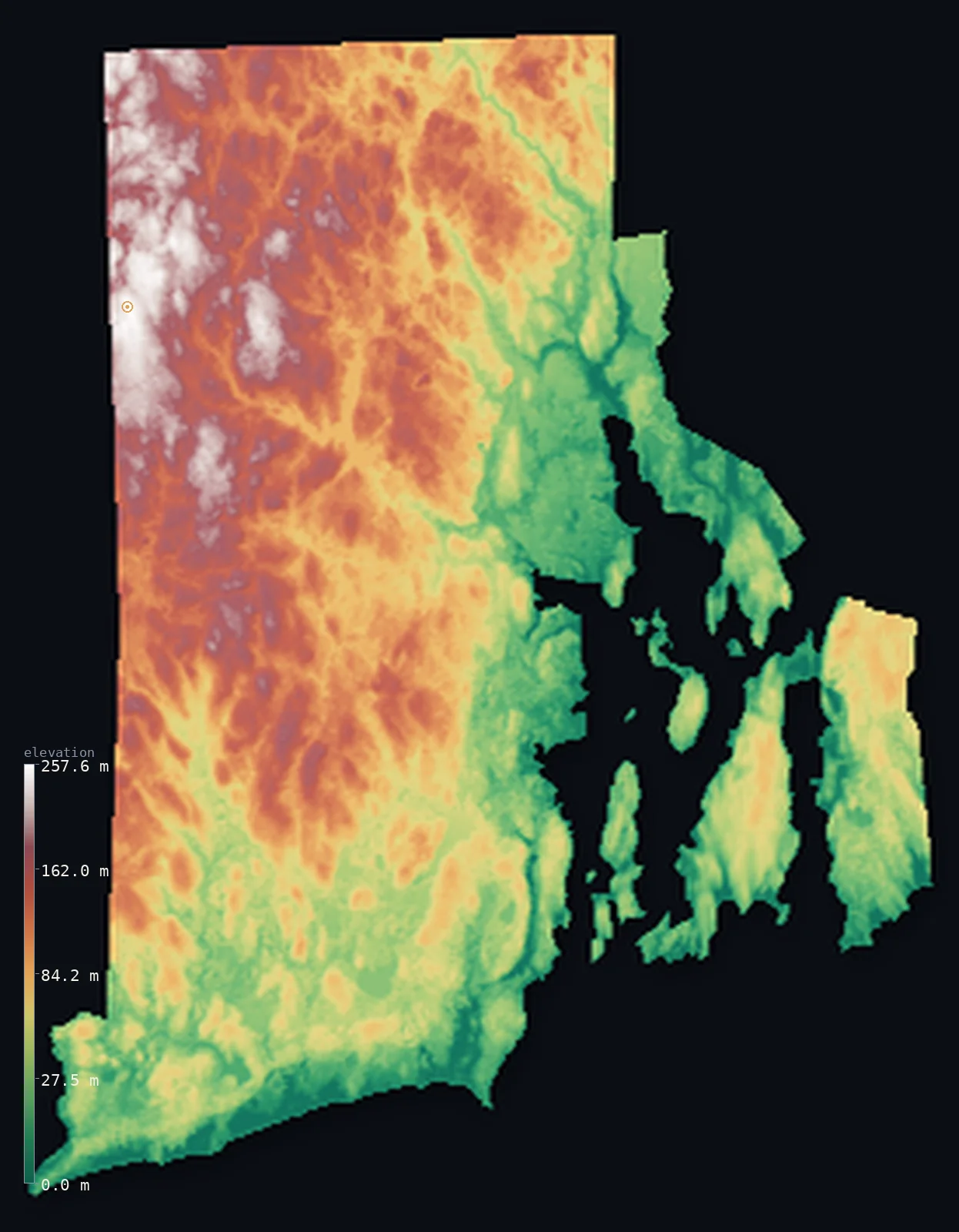
Rhode Island’s highest point is Jerimoth Hill at 810 ft (247 m); its lowest is Atlantic Ocean at 0 ft (0 m); the mean elevation is 270 ft (82.2 m).
- Highest point📚
- 810 ft247 m
- Jerimoth Hill.
- Lowest point📚
- 0 ft0 m
- Atlantic Ocean.
- Mean elevation⚙
- 270 ft82.2 m
- Computed from the GLO-30 surface model.
- Median elevation⚙
- 235 ft71.7 m
- Half of Rhode Island lies below this height.
- Elevation range📚
- 810 ft247 m
- From 0 m to Jerimoth Hill's 247 m.
- Above 50 m (164 ft)⚙
- 61%
- The state's higher ground.
- Official area📚
- 1,545 mi²4,001 km²
- Rhode Island.
Rhode Island at a glance
Jerimoth Hill was long notorious as the most difficult state high point to legally visit, until access was won.
source ↗Narragansett Bay, a drowned river valley, nearly cuts the smallest state in two.
source ↗Rhode Island is the smallest US state, yet has a surprisingly long, indented coastline.
source ↗The state's mean elevation is only about 60 m - among the lowest in the nation.
source ↗Despite its name, most of Rhode Island is on the mainland, not an island.
source ↗
Elevation profile of Rhode Island
The largest share of land, 17%, falls in the 0–20 m band, and 100% of the territory lies below 500 m (1,640 ft).
- 0–10 m (0–33 ft)9%
- 10–50 m (33–164 ft)31%
- above 50 m (164 ft)61%
Highest and lowest points
The highest point of Rhode Island, Jerimoth Hill, 247 m, a low wooded rise near the Connecticut border - for years famous as the hardest state high point to legally reach, guarded by a landowner, before public access was finally secured.
source ↗Highest peaks of Rhode Island
| Peak | Elevation | Range | Note |
|---|---|---|---|
| Jerimoth Hill↗ | 810 ft247 m | Western uplands | Highest point of Rhode Island, a low wooded rise. |
| Durfee Hill↗ | 797 ft243 m | Western uplands | The second-highest point in Rhode Island. |
| Buck Hill↗ | 722 ft220 m | Western uplands | A high point of the northwestern corner. |
| Chopmist Hill↗ | 722 ft220 m | Western uplands | A high rise of the western hills. |
| Woonsocket Hill↗ | 591 ft180 m | Northern uplands | A high point of the northern part of the state. |
Terrain regions of Rhode Island
Jerimoth Hill was long notorious as the most difficult state high point to legally visit, until access was won. ↗
The western uplands
↗Western Rhode Island is the state's higher ground - a band of low, forested hills along the Connecticut border, rising to Jerimoth Hill (247 m), the state's mod
The Narragansett lowlands
↗The heart of Rhode Island is the lowland around Narragansett Bay, a great arm of the sea nearly splitting the state, dotted with islands including Aquidneck Isl
The coast and islands
↗Southern Rhode Island is low coastal plain and shore - salt ponds, barrier beaches and the open Atlantic, with Block Island lying offshore. The whole state is s
The western uplands
the westWestern Rhode Island is the state's higher ground - a band of low, forested hills along the Connecticut border, rising to Jerimoth Hill (247 m), the state's modest high point. This is the most rural, wooded and elevated part of the smallest state.
The Narragansett lowlands
the centreThe heart of Rhode Island is the lowland around Narragansett Bay, a great arm of the sea nearly splitting the state, dotted with islands including Aquidneck Island. This low, settled country holds Providence and most of the population around the bay's shores.
The coast and islands
the coastSouthern Rhode Island is low coastal plain and shore - salt ponds, barrier beaches and the open Atlantic, with Block Island lying offshore. The whole state is small and low, quickly reaching the sea at zero elevation.
City elevations in Rhode Island
| City | Population | Elevation |
|---|---|---|
| Providence | 190,934 | 26 ft8 m |
| Woonsocket | 41,475 | 180 ft55 m |
| Coventry | 35,525 | 453 ft138 m |
| South Kingstown | 30,826 | 200 ft61 m |
| Newport | 24,232 | 39 ft12 m |
| Bristol | 22,795 | 85 ft26 m |
| Westerly | 17,936 | 49 ft15 m |
| East Greenwich | 13,682 | 131 ft40 m |
| Foster | 4,598 | 741 ft226 m |
| Hope Valley | 1,612 | 102 ft31 m |
Elevation sampled at each city centre from the Copernicus GLO-30 model. Cities and population from GeoNames (CC-BY 4.0).
Rhode Island in comparison
Rhode Island's terrain rises 810 ft (247 m) from sea level to Jerimoth Hill — about 3% of the height of Mount Everest, the world's highest point at 29,032 ft (8,849 m).
Frequently asked questions
What is the highest point in Rhode Island?
- Jerimoth Hill, 810 ft (247 m).
What is the average elevation of Rhode Island?
- About 60 m according to the USGS; this page also reports the area-weighted mean computed from the Copernicus GLO-30 model, 270 ft (82.2 m).
What is the lowest point in Rhode Island?
- Atlantic Ocean, 0 ft (0 m).
Jerimoth Hill was long notorious as the most difficult state high point to legally visit?
- Jerimoth Hill was long notorious as the most difficult state high point to legally visit, until access was won.
Where is the highest ground in Rhode Island?
- Western Rhode Island is the state's higher ground - a band of low, forested hills along the Connecticut border, rising to Jerimoth Hill (247 m), the state's modest high point. This is the most rural,
Is this a topographic, relief, contour, or elevation map of Rhode Island?
- They describe the same thing - terrain height. This page renders Rhode Island's actual elevation surface in interactive 3D (a relief or topographic view) and reports the statistics computed from it; a contour map shows the same data as lines of equal height.
About this map
The terrain is rendered from the Copernicus GLO-30 digital elevation model (ESA), masked to the US-RI boundary from geoBoundaries (gbOpen). Elevation statistics are computed directly from the model; peak names and researched facts are sourced and cited. See the methodology for the full pipeline.
This map renders 2,818 km² across 8 landmasses of Rhode Island. 5 smaller outlying parts — 28 km² in total — lie beyond the area shown here. Area statistics above count the full territory.
Our area-weighted mean, computed from the Copernicus GLO-30 model, is 270 ft (82.2 m); the figure commonly cited elsewhere is 197 ft (60 m) (U.S. Geological Survey). Rhode Island's mean elevation is about 60 m; the page reports the area-weighted figure computed from the Copernicus GLO-30 model.
Surveyed national figures: official area · high point.
Rendered from Copernicus GLO-30 (ESA, 2021 release), boundaries from geoBoundaries. Generated 2026-07-14.