Massachusetts Elevation Map
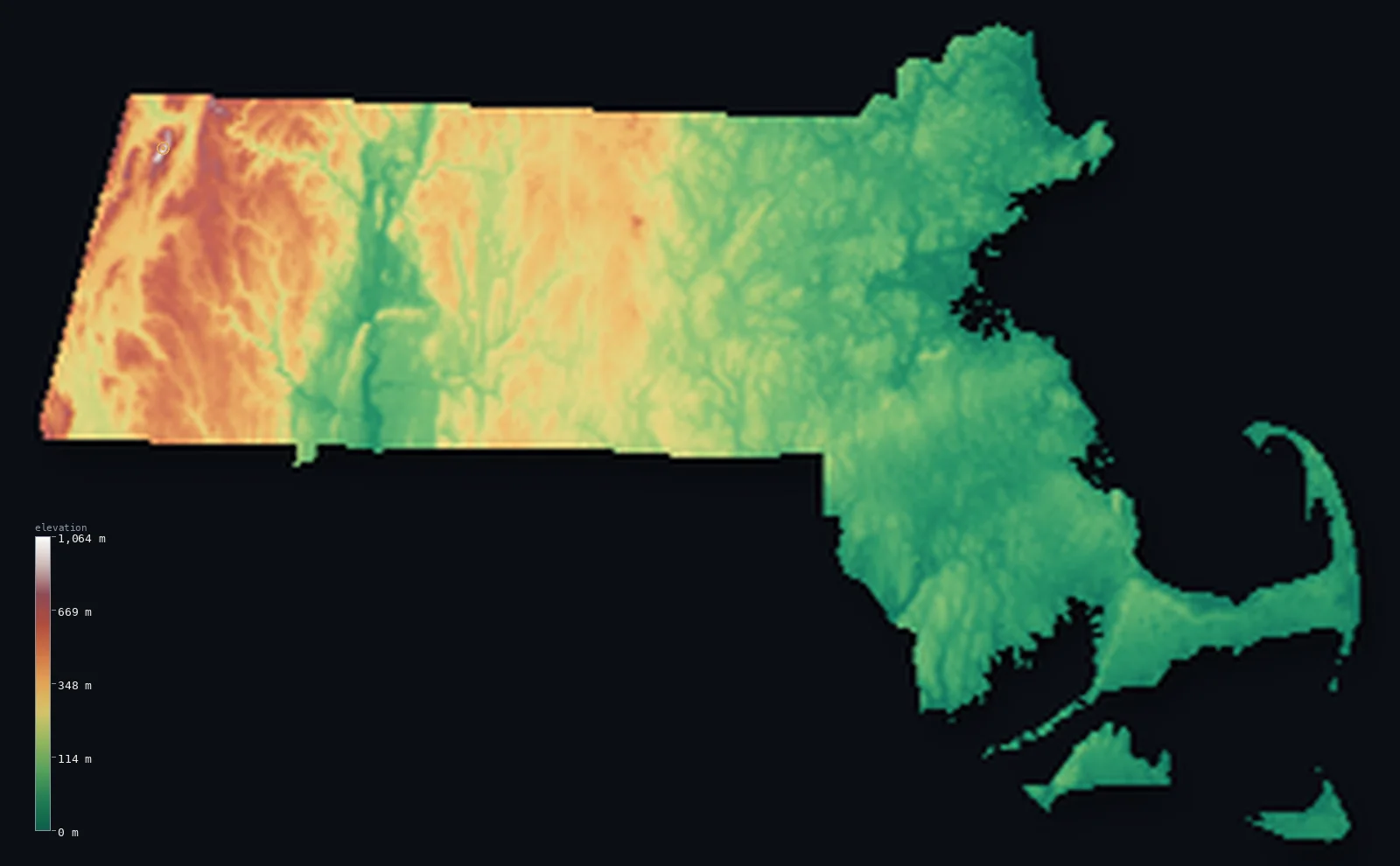
Massachusetts’s highest point is Mount Greylock at 3,488 ft (1,063 m); its lowest is Atlantic Ocean at 0 ft (0 m); the mean elevation is 558 ft (170 m).
- Highest point📚
- 3,488 ft1,063 m
- Mount Greylock.
- Lowest point📚
- 0 ft0 m
- Atlantic Ocean.
- Mean elevation⚙
- 558 ft170 m
- Computed from the GLO-30 surface model.
- Median elevation⚙
- 328 ft100 m
- Half of Massachusetts lies below this height.
- Elevation range📚
- 3,488 ft1,063 m
- From 0 m to Mount Greylock's 1063 m.
- Above 1,000 m (3,281 ft)⚙
- <1%
- The state's higher ground.
- Official area📚
- 10,554 mi²27,336 km²
- Massachusetts.
Massachusetts at a glance
From Mount Greylock's summit tower, five states are visible on a clear day.
source ↗Cape Cod, Martha's Vineyard and Nantucket are all glacial deposits left by the last Ice Age.
source ↗Mount Greylock's high slopes hold a rare boreal spruce-fir forest, a southern outpost of the northern woods.
source ↗The Berkshires in the west are the highest and most rural part of the state.
source ↗Cape Cod's hooked shape is slowly being reshaped by the sea that built it.
source ↗
Elevation profile of Massachusetts
The largest share of land, 50%, falls in the 0–100 m band, and 95% of the territory lies below 500 m (1,640 ft).
- below 500 m (1,640 ft)95%
- 500–1,000 m5%
- 1,000–2,000 m<1%
Highest and lowest points
The highest point of Massachusetts, Mount Greylock, 1,063 m, the high summit of the Berkshires in the state's far west - crowned by a war memorial tower and, on clear days, views across five states.
source ↗Highest peaks of Massachusetts
| Peak | Elevation | Range | Note |
|---|---|---|---|
| Mount Greylock↗ | 3,488 ft1,063 m | Berkshire Hills (Taconics) | Highest point of Massachusetts, in the Berkshires. |
| Saddle Ball Mountain↗ | 3,323 ft1,013 m | Berkshire Hills | A high summit on the Greylock massif. |
| Mount Fitch↗ | 3,251 ft991 m | Berkshire Hills | A high point of the Greylock range. |
| Mount Williams↗ | 3,120 ft951 m | Berkshire Hills | A northern summit of the Greylock massif. |
| Spruce Hill↗ | 2,100 ft640 m | Hoosac Range | A high point of the Hoosac Range to the east. |
Terrain regions of Massachusetts
From Mount Greylock's summit tower, five states are visible on a clear day. ↗
The Berkshires and western hills
↗Western Massachusetts is hill country - the Berkshire Hills and the Taconic Mountains along the New York border, where Mount Greylock (1,063 m) is the state's h
The Connecticut Valley and central uplands
↗Central Massachusetts holds the broad, fertile Connecticut River valley cutting north to south, flanked by the rolling central uplands. This gentler country of
The eastern lowlands and coast
↗Eastern Massachusetts is low coastal lowland - the populous corridor around Boston, sloping to a deeply indented Atlantic coast of bays, beaches and the hooked
The Berkshires and western hills
the westWestern Massachusetts is hill country - the Berkshire Hills and the Taconic Mountains along the New York border, where Mount Greylock (1,063 m) is the state's highest point. This is the state's highest, most rural region, of forested hills, valleys and old mill towns.
The Connecticut Valley and central uplands
the centreCentral Massachusetts holds the broad, fertile Connecticut River valley cutting north to south, flanked by the rolling central uplands. This gentler country of hills, farms and rivers separates the western mountains from the eastern lowlands.
The eastern lowlands and coast
the eastEastern Massachusetts is low coastal lowland - the populous corridor around Boston, sloping to a deeply indented Atlantic coast of bays, beaches and the hooked sandy arm of Cape Cod, with the islands of Martha's Vineyard and Nantucket offshore, all meeting the sea at zero elevation.
City elevations in Massachusetts
| City | Population | Elevation |
|---|---|---|
| Boston | 653,833 | 52 ft16 m |
| Worcester | 206,518 | 509 ft155 m |
| Springfield | 154,341 | 82 ft25 m |
| Lowell | 110,699 | 121 ft37 m |
| New Bedford | 101,079 | 79 ft24 m |
| Brockton | 95,314 | 118 ft36 m |
| Framingham | 68,318 | 174 ft53 m |
| Haverhill | 62,765 | 59 ft18 m |
| Barnstable | 47,821 | 56 ft17 m |
| Attleboro | 44,284 | 135 ft41 m |
Elevation sampled at each city centre from the Copernicus GLO-30 model. Cities and population from GeoNames (CC-BY 4.0).
Massachusetts in comparison
Massachusetts's terrain rises 3,488 ft (1,063 m) from sea level to Mount Greylock — about 12% of the height of Mount Everest, the world's highest point at 29,032 ft (8,849 m).
Frequently asked questions
What is the highest point in Massachusetts?
- Mount Greylock, 3,488 ft (1,063 m).
What is the average elevation of Massachusetts?
- About 150 m according to the USGS; this page also reports the area-weighted mean computed from the Copernicus GLO-30 model, 558 ft (170 m).
What is the lowest point in Massachusetts?
- Atlantic Ocean, 0 ft (0 m).
From Mount Greylock's summit tower?
- From Mount Greylock's summit tower, five states are visible on a clear day.
Where is the highest ground in Massachusetts?
- Western Massachusetts is hill country - the Berkshire Hills and the Taconic Mountains along the New York border, where Mount Greylock (1,063 m) is the state's highest point. This is the state's highes
Is this a topographic, relief, contour, or elevation map of Massachusetts?
- They describe the same thing - terrain height. This page renders Massachusetts's actual elevation surface in interactive 3D (a relief or topographic view) and reports the statistics computed from it; a contour map shows the same data as lines of equal height.
About this map
The terrain is rendered from the Copernicus GLO-30 digital elevation model (ESA), masked to the US-MA boundary from geoBoundaries (gbOpen). Elevation statistics are computed directly from the model; peak names and researched facts are sourced and cited. See the methodology for the full pipeline.
This map renders 21,245 km² across 30 landmasses of Massachusetts. 3 smaller outlying parts — 7 km² in total — lie beyond the area shown here. Area statistics above count the full territory.
Our area-weighted mean, computed from the Copernicus GLO-30 model, is 558 ft (170 m); the figure commonly cited elsewhere is 492 ft (150 m) (U.S. Geological Survey). Massachusetts's mean elevation is about 150 m; the page reports the area-weighted figure computed from the Copernicus GLO-30 model.
Surveyed national figures: official area · high point.
Rendered from Copernicus GLO-30 (ESA, 2021 release), boundaries from geoBoundaries. Generated 2026-07-14.