New Hampshire Elevation Map
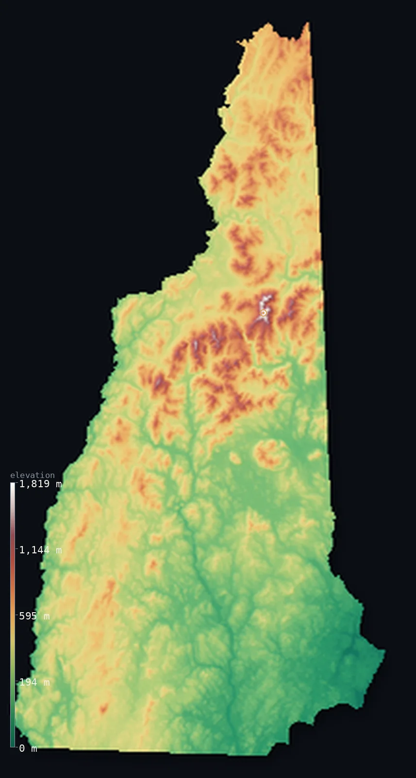
New Hampshire’s highest point is Mount Washington at 6,289 ft (1,917 m); its lowest is Atlantic Ocean at 0 ft (0 m); the mean elevation is 1,152 ft (351 m).
- Highest point📚
- 6,289 ft1,917 m
- Mount Washington.
- Lowest point📚
- 0 ft0 m
- Atlantic Ocean.
- Mean elevation⚙
- 1,152 ft351 m
- Computed from the GLO-30 surface model.
- Median elevation⚙
- 1,027 ft313 m
- Half of New Hampshire lies below this height.
- Elevation range📚
- 6,289 ft1,917 m
- From 0 m to Mount Washington's 1917 m.
- Above 1,000 m (3,281 ft)⚙
- 1%
- The state's higher ground.
- Official area📚
- 9,349 mi²24,214 km²
- New Hampshire.
New Hampshire at a glance
Mount Washington held the world record for the fastest surface wind ever measured, 372 km/h, for 62 years.
source ↗The summit's weather is so severe it is often compared to polar or high-Himalayan conditions.
source ↗New Hampshire has one of the shortest ocean coastlines of any US state, just 29 km.
source ↗The White Mountains are the highest range in the northeastern United States.
source ↗The Old Man of the Mountain, a natural rock profile and state symbol, collapsed in 2003.
source ↗
Elevation profile of New Hampshire
The largest share of land, 37%, falls in the 200–400 m band, and 79% of the territory lies below 500 m (1,640 ft).
- below 500 m (1,640 ft)79%
- 500–1,000 m20%
- 1,000–2,000 m1%
Highest and lowest points
The highest point of New Hampshire, Mount Washington, 1,917 m, the crown of the White Mountains - infamous for some of the most violent weather on Earth, where a surface wind of 372 km/h was recorded, long the fastest ever measured.
source ↗Highest peaks of New Hampshire
| Peak | Elevation | Range | Note |
|---|---|---|---|
| Mount Washington↗ | 6,289 ft1,917 m | White Mountains (Presidential Range) | Highest point of NH, home to extreme weather. |
| Mount Adams↗ | 5,774 ft1,760 m | Presidential Range | The second-highest peak in New Hampshire. |
| Mount Jefferson↗ | 5,712 ft1,741 m | Presidential Range | A high Presidential Range summit. |
| Mount Monroe↗ | 5,384 ft1,641 m | Presidential Range | A high peak beside Mount Washington. |
| Mount Madison↗ | 5,367 ft1,636 m | Presidential Range | The northern end of the Presidential Range. |
Terrain regions of New Hampshire
Mount Washington held the world record for the fastest surface wind ever measured, 372 km/h, for 62 years. ↗
The White Mountains
↗Northern New Hampshire is dominated by the White Mountains, the highest range in the northeastern United States. Their Presidential Range culminates in Mount Wa
The central hills and lakes
↗Central New Hampshire is rolling, forested hill country dotted with lakes, including the large Lake Winnipesaukee. Glacier-shaped and green, it slopes gradually
The southern lowlands and short coast
↗Southern New Hampshire is lower, gentler country of hills and river valleys around the Merrimack, holding most of the state's people. In the far southeast, the
The White Mountains
the northNorthern New Hampshire is dominated by the White Mountains, the highest range in the northeastern United States. Their Presidential Range culminates in Mount Washington (1,917 m), the state's summit, a peak famous worldwide for its ferocious, unpredictable weather and its high alpine zone above treeline.
The central hills and lakes
the centreCentral New Hampshire is rolling, forested hill country dotted with lakes, including the large Lake Winnipesaukee. Glacier-shaped and green, it slopes gradually southward from the mountains, laced with rivers and small ranges.
The southern lowlands and short coast
the south and coastSouthern New Hampshire is lower, gentler country of hills and river valleys around the Merrimack, holding most of the state's people. In the far southeast, the state has just 29 km of Atlantic coastline - one of the shortest of any coastal state - meeting the sea at zero elevation.
City elevations in New Hampshire
| City | Population | Elevation |
|---|---|---|
| Manchester | 110,229 | 262 ft80 m |
| Nashua | 87,970 | 167 ft51 m |
| Methuen | 52,044 | 121 ft37 m |
| Concord | 43,976 | 289 ft88 m |
| Dover | 30,880 | 72 ft22 m |
| Keene | 23,265 | 489 ft149 m |
| Laconia | 16,227 | 505 ft154 m |
| Lebanon | 13,579 | 594 ft181 m |
| Claremont | 12,984 | 495 ft151 m |
| Hampton | 9,656 | 43 ft13 m |
Elevation sampled at each city centre from the Copernicus GLO-30 model. Cities and population from GeoNames (CC-BY 4.0).
New Hampshire in comparison
New Hampshire's terrain rises 6,289 ft (1,917 m) from sea level to Mount Washington — about 22% of the height of Mount Everest, the world's highest point at 29,032 ft (8,849 m).
Frequently asked questions
What is the highest point in New Hampshire?
- Mount Washington, 6,289 ft (1,917 m).
What is the average elevation of New Hampshire?
- About 300 m according to the USGS; this page also reports the area-weighted mean computed from the Copernicus GLO-30 model, 1,152 ft (351 m).
What is the lowest point in New Hampshire?
- Atlantic Ocean, 0 ft (0 m).
Mount Washington held the world record for the fastest surface wind ever measured?
- Mount Washington held the world record for the fastest surface wind ever measured, 372 km/h, for 62 years.
Where is the highest ground in New Hampshire?
- Northern New Hampshire is dominated by the White Mountains, the highest range in the northeastern United States. Their Presidential Range culminates in Mount Washington (1,917 m), the state's summit,
Is this a topographic, relief, contour, or elevation map of New Hampshire?
- They describe the same thing - terrain height. This page renders New Hampshire's actual elevation surface in interactive 3D (a relief or topographic view) and reports the statistics computed from it; a contour map shows the same data as lines of equal height.
About this map
The terrain is rendered from the Copernicus GLO-30 digital elevation model (ESA), masked to the US-NH boundary from geoBoundaries (gbOpen). Elevation statistics are computed directly from the model; peak names and researched facts are sourced and cited. See the methodology for the full pipeline.
Our area-weighted mean, computed from the Copernicus GLO-30 model, is 1,152 ft (351 m); the figure commonly cited elsewhere is 984 ft (300 m) (U.S. Geological Survey). New Hampshire's mean elevation is about 300 m; the page reports the area-weighted figure computed from the Copernicus GLO-30 model.
Surveyed national figures: official area · high point.
Rendered from Copernicus GLO-30 (ESA, 2021 release), boundaries from geoBoundaries. Generated 2026-07-14.