Maine Elevation Map
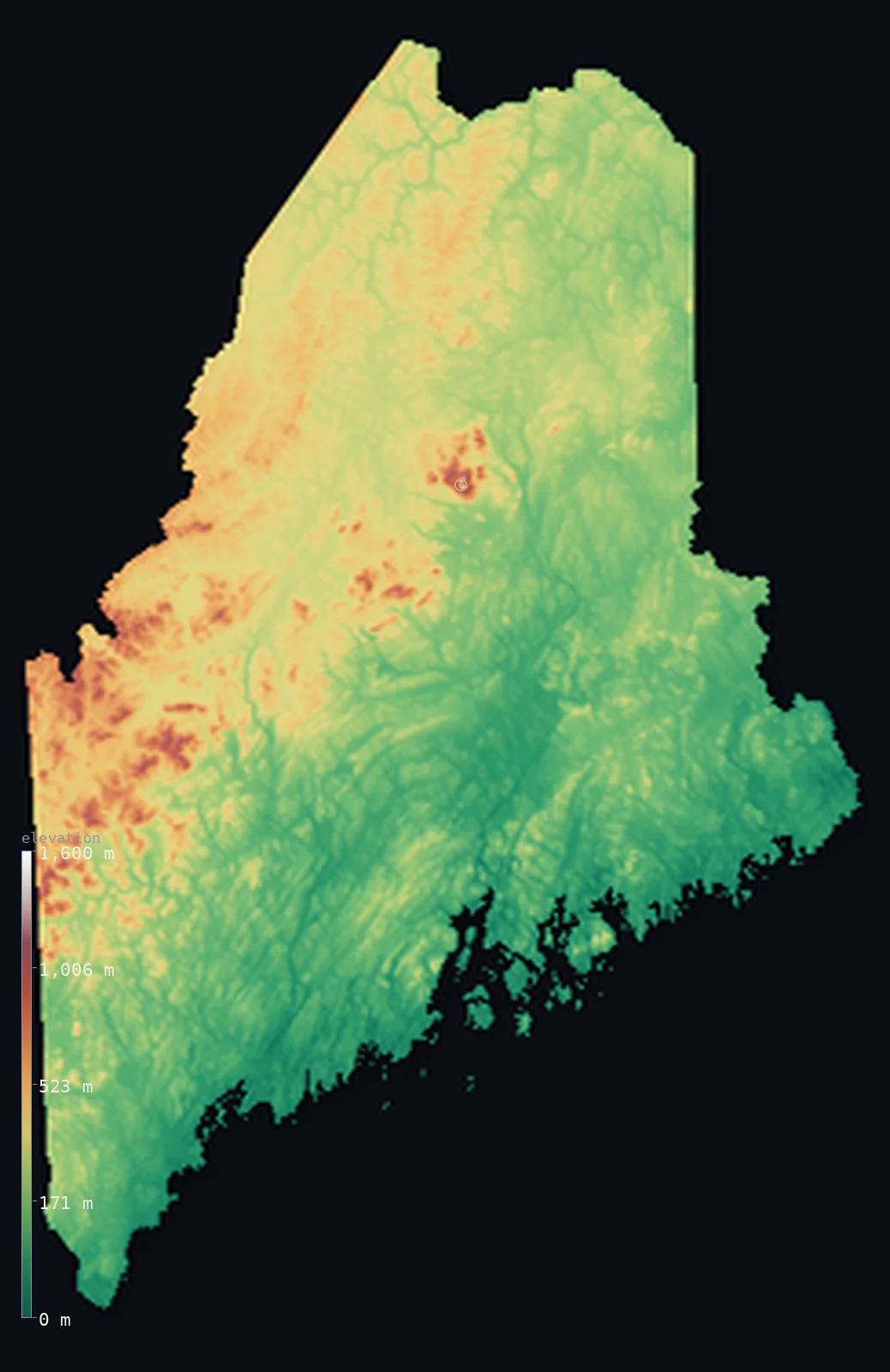
Maine’s highest point is Mount Katahdin at 5,269 ft (1,606 m); its lowest is Atlantic Ocean at 0 ft (0 m); the mean elevation is 771 ft (235 m).
- Highest point📚
- 5,269 ft1,606 m
- Mount Katahdin.
- Lowest point📚
- 0 ft0 m
- Atlantic Ocean.
- Mean elevation⚙
- 771 ft235 m
- Computed from the GLO-30 surface model.
- Median elevation⚙
- 636 ft194 m
- Half of Maine lies below this height.
- Elevation range📚
- 5,269 ft1,606 m
- From 0 m to Mount Katahdin's 1606 m.
- Above 1,000 m (3,281 ft)⚙
- <1%
- The state's higher ground.
- Official area📚
- 35,380 mi²91,633 km²
- Maine.
Maine at a glance
Mount Katahdin is the northern terminus of the 3,500 km Appalachian Trail.
source ↗By tradition, Katahdin's summit is the first place in the US to catch the sunrise.
source ↗Maine's North Woods is one of the largest undeveloped forest tracts in the eastern United States.
source ↗The Bay of Fundy tides along Maine's Downeast coast are among the highest on Earth.
source ↗Maine has more coastline than California despite being far smaller, due to its ragged shore.
source ↗
Elevation profile of Maine
The largest share of land, 51%, falls in the 0–200 m band, and 93% of the territory lies below 500 m (1,640 ft).
- below 500 m (1,640 ft)93%
- 500–1,000 m7%
- 1,000–2,000 m<1%
Highest and lowest points
The highest point of Maine, Mount Katahdin, 1,606 m, a great granite monolith rising alone from the northern forest - the northern terminus of the Appalachian Trail and, by tradition, the first place in the United States to catch the morning sun.
source ↗Highest peaks of Maine
| Peak | Elevation | Range | Note |
|---|---|---|---|
| Mount Katahdin↗ | 5,269 ft1,606 m | Longfellow Mountains | Highest point of Maine, northern end of the Appalachian Trail. |
| Sugarloaf↗ | 4,236 ft1,291 m | Longfellow Mountains | The second-highest peak in Maine, a ski mountain. |
| Old Speck Mountain↗ | 4,180 ft1,274 m | Mahoosuc Range | A high peak near the New Hampshire border. |
| Crocker Mountain↗ | 4,160 ft1,268 m | Longfellow Mountains | A high peak of the western mountains. |
| Bigelow Mountain↗ | 4,150 ft1,265 m | Longfellow Mountains | A high ridge above the Carrabassett Valley. |
Terrain regions of Maine
Mount Katahdin is the northern terminus of the 3,500 km Appalachian Trail. ↗
The mountains and the north woods
↗Western and northern Maine is mountain-and-forest country - the Longfellow Mountains, the northern reach of the Appalachians, crowned by the great granite mass
The interior hills and lakes
↗Central Maine is rolling hill-and-lake country, glacier-shaped, forested and studded with thousands of lakes and ponds, sloping gradually from the western mount
The rocky coast
↗Maine's defining edge is its coast - a deeply indented, rocky shore of peninsulas, bays and thousands of islands, from the tidal flats of the southwest to the c
The mountains and the north woods
the west and northWestern and northern Maine is mountain-and-forest country - the Longfellow Mountains, the northern reach of the Appalachians, crowned by the great granite mass of Mount Katahdin (1,606 m). Around them stretches the vast, lake-dotted North Woods, one of the largest tracts of undeveloped forest in the eastern United States.
The interior hills and lakes
the centreCentral Maine is rolling hill-and-lake country, glacier-shaped, forested and studded with thousands of lakes and ponds, sloping gradually from the western mountains toward the coast. The state's rivers gather here on their way to the sea.
The rocky coast
the coastMaine's defining edge is its coast - a deeply indented, rocky shore of peninsulas, bays and thousands of islands, from the tidal flats of the southwest to the cliffs of Acadia and the far Downeast. Though the highest tides in the country pound it, the land meets the Atlantic at sea level.
City elevations in Maine
| City | Population | Elevation |
|---|---|---|
| Portland | 66,881 | 82 ft25 m |
| Lewiston | 36,202 | 213 ft65 m |
| Bangor | 32,391 | 59 ft18 m |
| Portsmouth | 21,530 | 36 ft11 m |
| Sanford | 20,893 | 308 ft94 m |
| Augusta | 18,899 | 128 ft39 m |
| Presque Isle | 9,171 | 453 ft138 m |
| Ellsworth | 7,857 | 108 ft33 m |
| Rockland | 7,237 | 33 ft10 m |
| Skowhegan | 6,297 | 174 ft53 m |
Elevation sampled at each city centre from the Copernicus GLO-30 model. Cities and population from GeoNames (CC-BY 4.0).
Maine in comparison
Maine's terrain rises 5,269 ft (1,606 m) from sea level to Mount Katahdin — about 18% of the height of Mount Everest, the world's highest point at 29,032 ft (8,849 m).
Frequently asked questions
What is the highest point in Maine?
- Mount Katahdin, 5,269 ft (1,606 m).
What is the average elevation of Maine?
- About 180 m according to the USGS; this page also reports the area-weighted mean computed from the Copernicus GLO-30 model, 771 ft (235 m).
What is the lowest point in Maine?
- Atlantic Ocean, 0 ft (0 m).
Mount Katahdin is the northern terminus of the 3,500 km Appalachian Trail?
- Mount Katahdin is the northern terminus of the 3,500 km Appalachian Trail.
Where is the highest ground in Maine?
- Western and northern Maine is mountain-and-forest country - the Longfellow Mountains, the northern reach of the Appalachians, crowned by the great granite mass of Mount Katahdin (1,606 m). Around them
Is this a topographic, relief, contour, or elevation map of Maine?
- They describe the same thing - terrain height. This page renders Maine's actual elevation surface in interactive 3D (a relief or topographic view) and reports the statistics computed from it; a contour map shows the same data as lines of equal height.
About this map
The terrain is rendered from the Copernicus GLO-30 digital elevation model (ESA), masked to the US-ME boundary from geoBoundaries (gbOpen). Elevation statistics are computed directly from the model; peak names and researched facts are sourced and cited. See the methodology for the full pipeline.
This map renders 84,900 km² across 205 landmasses of Maine. 2 smaller outlying parts — 1 km² in total — lie beyond the area shown here. Area statistics above count the full territory.
Our area-weighted mean, computed from the Copernicus GLO-30 model, is 771 ft (235 m); the figure commonly cited elsewhere is 591 ft (180 m) (U.S. Geological Survey). Maine's mean elevation is about 180 m; the page reports the area-weighted figure computed from the Copernicus GLO-30 model.
Surveyed national figures: official area · high point.
Rendered from Copernicus GLO-30 (ESA, 2021 release), boundaries from geoBoundaries. Generated 2026-07-14.