Delaware Elevation Map
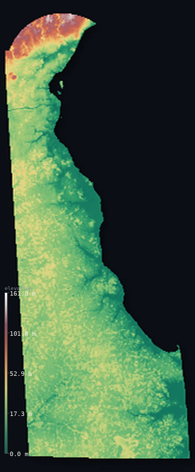
Delaware’s highest point is Ebright Azimuth at 449 ft (137 m); its lowest is Atlantic Ocean at 0 ft (0 m); the mean elevation is 61 ft (18.5 m).
- Highest point📚
- 449 ft137 m
- Ebright Azimuth.
- Lowest point📚
- 0 ft0 m
- Atlantic Ocean.
- Mean elevation⚙
- 61 ft18.5 m
- Computed from the GLO-30 surface model.
- Median elevation⚙
- 49 ft15 m
- Half of Delaware lies below this height.
- Elevation range📚
- 449 ft137 m
- From 0 m to Ebright Azimuth's 137 m.
- Above 50 m (164 ft)⚙
- 4%
- The state's higher ground.
- Official area📚
- 2,489 mi²6,446 km²
- Delaware.
Delaware at a glance
Ebright Azimuth, at just 137 m, is the second-lowest state high point in the United States after Florida's.
source ↗Delaware is the second-smallest and one of the flattest and lowest states, mean elevation about 18 m.
source ↗Only the small northern tip of Delaware has any real hills; the rest is flat coastal plain.
source ↗The Delaware Bay is one of the most important stopovers for migrating shorebirds on Earth.
source ↗Delaware's high point sits beside a suburban road, marked by a small sign.
source ↗
Elevation profile of Delaware
The largest share of land, 67%, falls in the 0–20 m band, and 100% of the territory lies below 500 m (1,640 ft).
- 0–10 m (0–33 ft)29%
- 10–50 m (33–164 ft)67%
- above 50 m (164 ft)4%
Highest and lowest points
The highest point of Delaware, Ebright Azimuth, just 137 m, near the Pennsylvania border - the second-lowest state high point in the nation, a spot beside a suburban road rather than any kind of peak.
source ↗Highest peaks of Delaware
| Peak | Elevation | Range | Note |
|---|---|---|---|
| Ebright Azimuth↗ | 449 ft137 m | Piedmont edge | Highest point of Delaware, a roadside spot. |
| Centerville high ground↗ | 427 ft130 m | Piedmont edge | High Piedmont ground of northern Delaware. |
| Chestnut Hill↗ | 394 ft120 m | Piedmont edge | A high point of the small northern hills. |
| Piedmont edge highpoints↗ | 361 ft110 m | Piedmont edge | Scattered high ground of the far north. |
| Iron Hill↗ | 328 ft100 m | Piedmont edge | A low but prominent hill near Newark. |
Terrain regions of Delaware
Ebright Azimuth, at just 137 m, is the second-lowest state high point in the United States after Florida's. ↗
The northern Piedmont
↗Only the small northern tip of Delaware reaches the rolling Piedmont, where the state's modest high point, Ebright Azimuth (137 m), sits near the Pennsylvania l
The Atlantic Coastal Plain
↗Almost all of Delaware is flat Atlantic Coastal Plain - low, level farmland, forest and wetland covering the whole state south of Wilmington. The land barely ri
The bays and coast
↗Eastern and southern Delaware meet the water - the broad Delaware Bay and River on the east, and the Atlantic beaches and coastal lagoons of the south. Marsh, t
The northern Piedmont
the far northOnly the small northern tip of Delaware reaches the rolling Piedmont, where the state's modest high point, Ebright Azimuth (137 m), sits near the Pennsylvania line. This narrow band of low hills, around Wilmington, is the only part of Delaware with any real relief.
The Atlantic Coastal Plain
most of the stateAlmost all of Delaware is flat Atlantic Coastal Plain - low, level farmland, forest and wetland covering the whole state south of Wilmington. The land barely rises above sea level, sloping imperceptibly toward the coast.
The bays and coast
the coastEastern and southern Delaware meet the water - the broad Delaware Bay and River on the east, and the Atlantic beaches and coastal lagoons of the south. Marsh, tidal flat and low barrier beach fringe the state, all at or near sea level.
City elevations in Delaware
| City | Population | Elevation |
|---|---|---|
| Wilmington | 70,898 | 118 ft36 m |
| Dover | 39,403 | 36 ft11 m |
| Newark | 33,817 | 131 ft40 m |
| Middletown | 20,372 | 69 ft21 m |
| Smyrna | 11,319 | 39 ft12 m |
| Milford | 10,252 | 20 ft6 m |
| Seaford | 7,586 | 30 ft9 m |
| Georgetown | 7,051 | 56 ft17 m |
| Nassau | 3,699 | 26 ft8 m |
| Selbyville | 2,397 | 39 ft12 m |
Elevation sampled at each city centre from the Copernicus GLO-30 model. Cities and population from GeoNames (CC-BY 4.0).
Delaware in comparison
Delaware's terrain rises 449 ft (137 m) from sea level to Ebright Azimuth — about 2% of the height of Mount Everest, the world's highest point at 29,032 ft (8,849 m).
Frequently asked questions
What is the highest point in Delaware?
- Ebright Azimuth, 449 ft (137 m).
What is the average elevation of Delaware?
- About 18 m according to the USGS; this page also reports the area-weighted mean computed from the Copernicus GLO-30 model, 61 ft (18.5 m).
What is the lowest point in Delaware?
- Atlantic Ocean, 0 ft (0 m).
Ebright Azimuth?
- Ebright Azimuth, at just 137 m, is the second-lowest state high point in the United States after Florida's.
Where is the highest ground in Delaware?
- Only the small northern tip of Delaware reaches the rolling Piedmont, where the state's modest high point, Ebright Azimuth (137 m), sits near the Pennsylvania line. This narrow band of low hills, arou
Is this a topographic, relief, contour, or elevation map of Delaware?
- They describe the same thing - terrain height. This page renders Delaware's actual elevation surface in interactive 3D (a relief or topographic view) and reports the statistics computed from it; a contour map shows the same data as lines of equal height.
About this map
The terrain is rendered from the Copernicus GLO-30 digital elevation model (ESA), masked to the US-DE boundary from geoBoundaries (gbOpen). Elevation statistics are computed directly from the model; peak names and researched facts are sourced and cited. See the methodology for the full pipeline.
Our area-weighted mean, computed from the Copernicus GLO-30 model, is 61 ft (18.5 m); the figure commonly cited elsewhere is 59 ft (18 m) (U.S. Geological Survey). Delaware's mean elevation is about 18 m; the page reports the area-weighted figure computed from the Copernicus GLO-30 model.
Surveyed national figures: official area · high point.
Rendered from Copernicus GLO-30 (ESA, 2021 release), boundaries from geoBoundaries. Generated 2026-07-14.