Maryland Elevation Map
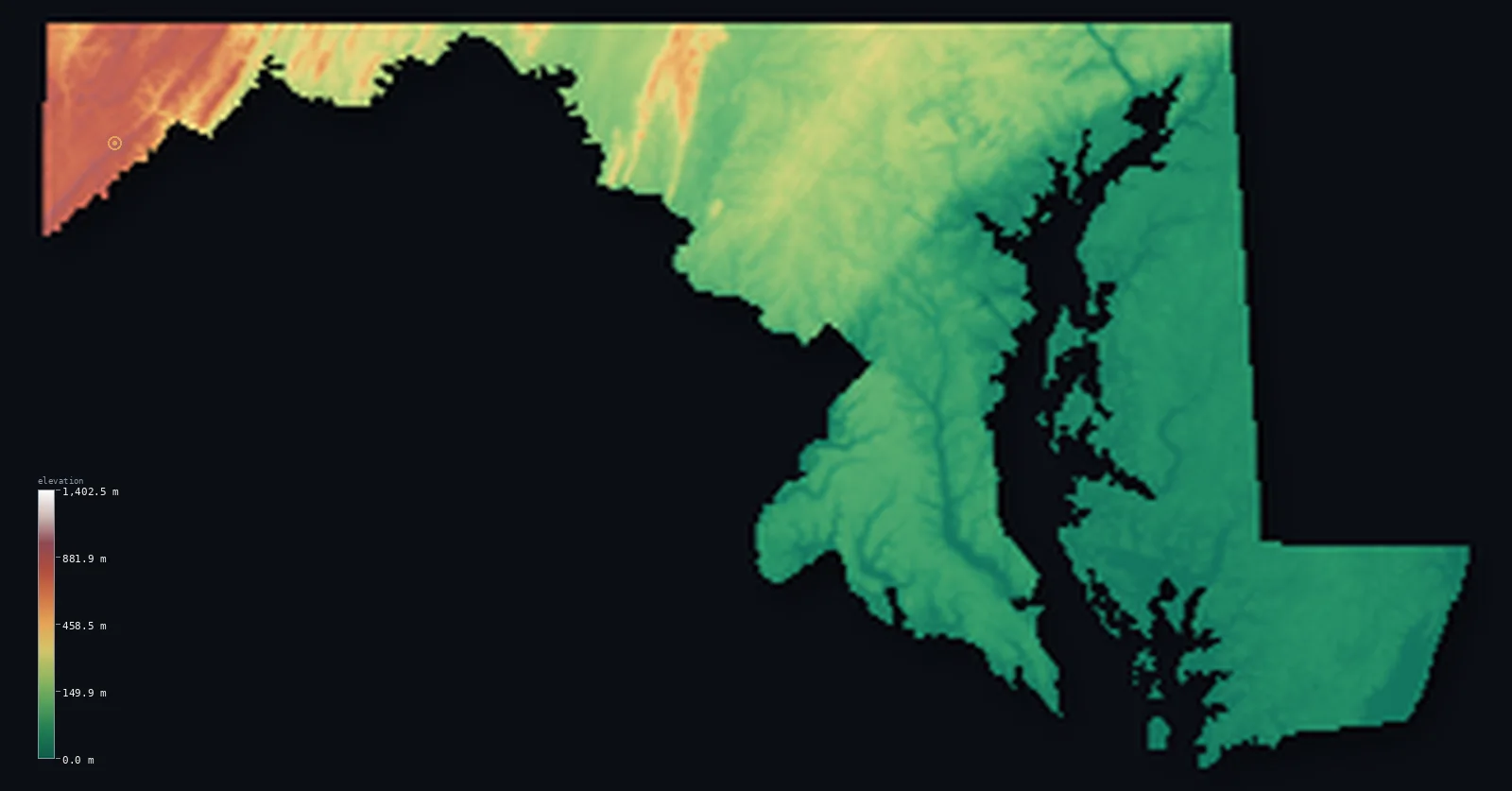
Maryland’s highest point is Hoye-Crest (Backbone Mountain) at 3,360 ft (1,024 m); its lowest is Atlantic Ocean at 0 ft (0 m); the mean elevation is 429 ft (131 m).
- Highest point📚
- 3,360 ft1,024 m
- Hoye-Crest (Backbone Mountain).
- Lowest point📚
- 0 ft0 m
- Atlantic Ocean.
- Mean elevation⚙
- 429 ft131 m
- Computed from the GLO-30 surface model.
- Median elevation⚙
- 159 ft48.6 m
- Half of Maryland lies below this height.
- Elevation range📚
- 3,360 ft1,024 m
- From 0 m to Hoye-Crest (Backbone Mountain)'s 1024 m.
- Above 50 m (164 ft)⚙
- 49%
- The state's higher ground.
- Official area📚
- 12,406 mi²32,131 km²
- Maryland.
Maryland at a glance
Maryland spans from 1,024 m in the Appalachian west to sea level, across a state pinched to under 3 km wide at one point.
source ↗The Chesapeake Bay, the largest estuary in the US, nearly cuts Maryland in two.
source ↗At its narrowest, near Hancock, Maryland is less than 3 km from north to south.
source ↗Backbone Mountain's high point is a remote Appalachian ridge far from the populous bay country.
source ↗Maryland's shoreline, counting the Chesapeake, is longer than that of many far larger states.
source ↗
Elevation profile of Maryland
The largest share of land, 59%, falls in the 0–100 m band, and 93% of the territory lies below 500 m (1,640 ft).
- 0–10 m (0–33 ft)18%
- 10–50 m (33–164 ft)33%
- above 50 m (164 ft)49%
Highest and lowest points
The highest point of Maryland, Hoye-Crest on Backbone Mountain, 1,024 m, in the state's far western panhandle - a remote Appalachian ridge nearly 400 km from the low Eastern Shore across the Chesapeake.
source ↗Hoye-Crest (Backbone Mountain) is a border summit: its peak lies just outside the generalized Maryland boundary, so the highest fully in-territory land pixel in the model is 3,378 ft (1,030 m). The headline figure above is the surveyed elevation of the recognised national high point.
Highest peaks of Maryland
| Peak | Elevation | Range | Note |
|---|---|---|---|
| Hoye-Crest (Backbone Mountain)↗ | 3,360 ft1,024 m | Allegheny Mountains | Highest point of Maryland, in the far west panhandle. |
| Backbone Mountain ridge↗ | 3,314 ft1,010 m | Allegheny Mountains | The long ridge around Hoye-Crest. |
| Meadow Mountain↗ | 3,199 ft975 m | Allegheny Mountains | A high ridge of far western Maryland. |
| Big Savage Mountain↗ | 2,904 ft885 m | Allegheny Mountains | A high western ridge near the panhandle. |
| Dans Mountain↗ | 2,854 ft870 m | Allegheny Mountains | A high ridge above the Cumberland valley. |
Terrain regions of Maryland
Maryland spans from 1,024 m in the Appalachian west to sea level, across a state pinched to under 3 km wide at one point. ↗
The Appalachian west
↗Maryland's narrow western panhandle reaches into the Appalachian Mountains - the Allegheny highlands and Ridge and Valley, where Hoye-Crest on Backbone Mountain
The Piedmont and central Maryland
↗Central Maryland is the rolling Piedmont, red-clay hills and valleys descending from the mountains to the fall line at Baltimore and Washington's edge. This is
The Chesapeake and coastal plain
↗Eastern and southern Maryland is low coastal plain, dominated by the great Chesapeake Bay, which nearly splits the state. Beyond it the flat Eastern Shore reach
The Appalachian west
the far westMaryland's narrow western panhandle reaches into the Appalachian Mountains - the Allegheny highlands and Ridge and Valley, where Hoye-Crest on Backbone Mountain (1,024 m) is the state's highest point. This is a cool, forested, mountainous strip utterly unlike the rest of the state.
The Piedmont and central Maryland
the centreCentral Maryland is the rolling Piedmont, red-clay hills and valleys descending from the mountains to the fall line at Baltimore and Washington's edge. This is the populous, varied heart of the state between mountains and bay.
The Chesapeake and coastal plain
the eastEastern and southern Maryland is low coastal plain, dominated by the great Chesapeake Bay, which nearly splits the state. Beyond it the flat Eastern Shore reaches to the Atlantic, a land of marsh, farm and tidewater at sea level - the Chesapeake giving Maryland its extraordinarily long, indented shoreline.
City elevations in Maryland
| City | Population | Elevation |
|---|---|---|
| Baltimore | 585,708 | 79 ft24 m |
| Germantown | 86,395 | 459 ft140 m |
| Silver Spring | 71,452 | 348 ft106 m |
| Frederick | 69,479 | 299 ft91 m |
| Waldorf | 67,752 | 220 ft67 m |
| South Bel Air | 48,828 | 381 ft116 m |
| Annapolis | 40,812 | 49 ft15 m |
| Hagerstown | 40,432 | 554 ft169 m |
| Salisbury | 32,899 | 30 ft9 m |
| Eldersburg | 30,531 | 640 ft195 m |
Elevation sampled at each city centre from the Copernicus GLO-30 model. Cities and population from GeoNames (CC-BY 4.0).
Maryland in comparison
Maryland's terrain rises 3,360 ft (1,024 m) from sea level to Hoye-Crest (Backbone Mountain) — about 12% of the height of Mount Everest, the world's highest point at 29,032 ft (8,849 m).
Frequently asked questions
What is the highest point in Maryland?
- Hoye-Crest (Backbone Mountain), 3,360 ft (1,024 m).
What is the average elevation of Maryland?
- About 110 m according to the USGS; this page also reports the area-weighted mean computed from the Copernicus GLO-30 model, 429 ft (131 m).
What is the lowest point in Maryland?
- Atlantic Ocean, 0 ft (0 m).
Maryland spans from 1,024 m in the Appalachian west to sea level?
- Maryland spans from 1,024 m in the Appalachian west to sea level, across a state pinched to under 3 km wide at one point.
Where is the highest ground in Maryland?
- Maryland's narrow western panhandle reaches into the Appalachian Mountains - the Allegheny highlands and Ridge and Valley, where Hoye-Crest on Backbone Mountain (1,024 m) is the state's highest point.
Is this a topographic, relief, contour, or elevation map of Maryland?
- They describe the same thing - terrain height. This page renders Maryland's actual elevation surface in interactive 3D (a relief or topographic view) and reports the statistics computed from it; a contour map shows the same data as lines of equal height.
About this map
The terrain is rendered from the Copernicus GLO-30 digital elevation model (ESA), masked to the US-MD boundary from geoBoundaries (gbOpen). Elevation statistics are computed directly from the model; peak names and researched facts are sourced and cited. See the methodology for the full pipeline.
Our area-weighted mean, computed from the Copernicus GLO-30 model, is 429 ft (131 m); the figure commonly cited elsewhere is 361 ft (110 m) (U.S. Geological Survey). Maryland's mean elevation is about 110 m; the page reports the area-weighted figure computed from the Copernicus GLO-30 model.
Surveyed national figures: official area · high point.
Rendered from Copernicus GLO-30 (ESA, 2021 release), boundaries from geoBoundaries. Generated 2026-07-14.