Arkansas Elevation Map
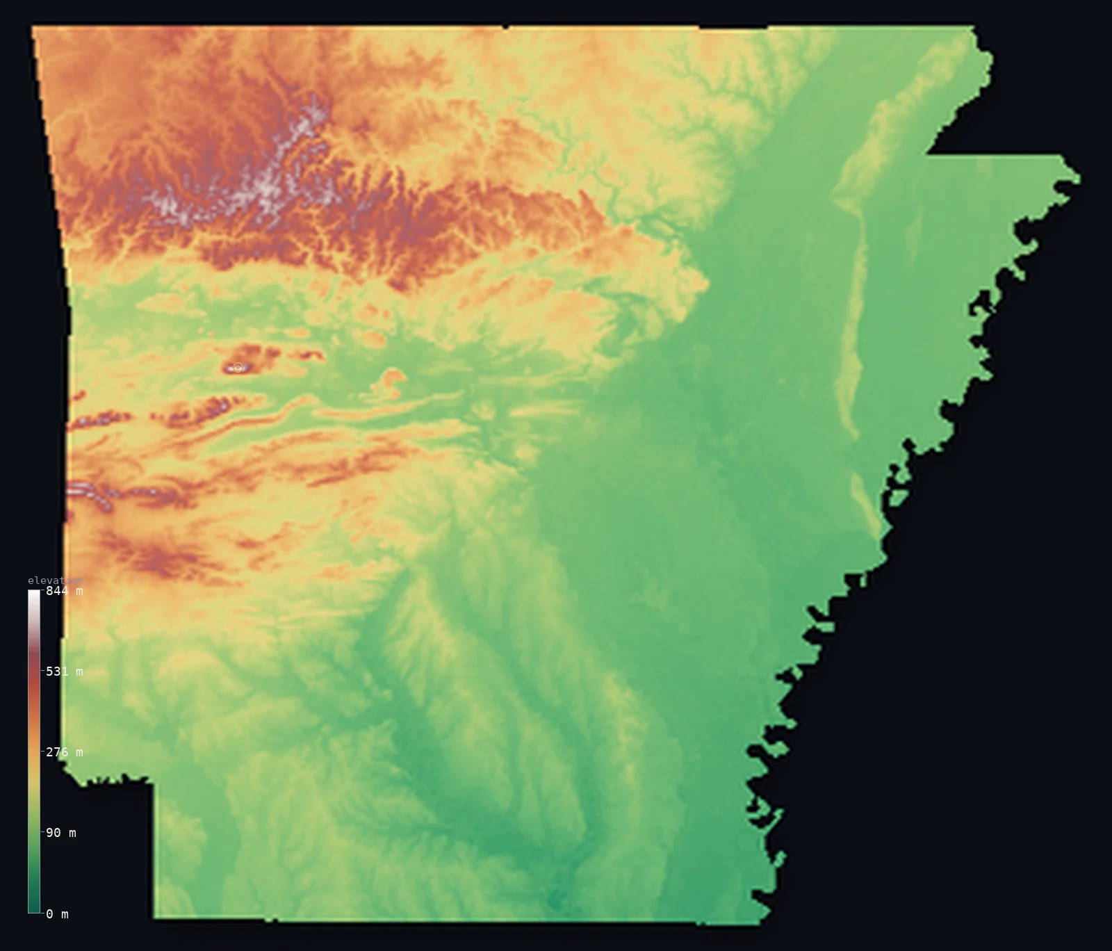
Arkansas’s highest point is Magazine Mountain at 2,753 ft (839 m); its lowest is Ouachita River at 56 ft (17 m); the mean elevation is 541 ft (165 m).
- Highest point📚
- 2,753 ft839 m
- Magazine Mountain.
- Lowest point📚
- 56 ft17 m
- Ouachita River.
- Mean elevation⚙
- 541 ft165 m
- Computed from the GLO-30 surface model.
- Median elevation⚙
- 338 ft103 m
- Half of Arkansas lies below this height.
- Elevation range📚
- 2,697 ft822 m
- From 17 m to Magazine Mountain's 839 m.
- Official area📚
- 53,179 mi²137,732 km²
- Arkansas.
Arkansas at a glance
Magazine Mountain is a flat-topped mesa, not a peak, high enough to have its own cooler climate.
source ↗The Ouachita Mountains are one of the few major mountain ranges in North America that run east-west.
source ↗Arkansas's Crater of Diamonds is the only diamond-bearing site in the world open to public digging.
source ↗The Buffalo River in the Ozarks was the first designated National River in the United States.
source ↗The state spans rugged Ozark highlands and the flat Mississippi Delta within its borders.
source ↗
Elevation profile of Arkansas
The largest share of land, 49%, falls in the 0–100 m band, and 97% of the territory lies below 500 m (1,640 ft).
- below 500 m (1,640 ft)97%
- 500–1,000 m3%
Highest and lowest points
The highest point of Arkansas, Magazine Mountain (Mount Magazine), 839 m, a flat-topped mesa in the Ouachita-Ozark country - its summit standing high enough to catch its own weather above the Arkansas River valley.
source ↗Highest peaks of Arkansas
| Peak | Elevation | Range | Note |
|---|---|---|---|
| Magazine Mountain↗ | 2,753 ft839 m | Ouachita Mountains area | Highest point of Arkansas, a flat-topped mountain. |
| Rich Mountain↗ | 2,680 ft817 m | Ouachita Mountains | The second-highest peak in Arkansas, on the Oklahoma line. |
| Blue Mountain↗ | 2,362 ft720 m | Ouachita Mountains | A high ridge of the Ouachita country. |
| White Rock Mountain↗ | 2,231 ft680 m | Ozark Mountains | A high point of the Ozark National Forest. |
| Petit Jean Mountain↗ | 1,115 ft340 m | Arkansas River Valley | A famous flat-topped mountain above the Arkansas River. |
Terrain regions of Arkansas
Magazine Mountain is a flat-topped mesa, not a peak, high enough to have its own cooler climate. ↗
The Ozark Mountains
↗Northern Arkansas is Ozark country - a rugged, forested plateau of steep hills, bluffs, caves and clear rivers, deeply cut by the White and Buffalo rivers. It i
The Ouachita Mountains and river valley
↗Central Arkansas holds the Ouachita Mountains, unusual east-west folded ridges, separated from the Ozarks by the broad Arkansas River Valley. Rising from that v
The Delta and coastal plain
↗Eastern and southern Arkansas is low, flat country - the Mississippi Delta of rich cotton and rice land in the east, and the Gulf Coastal Plain of pine forest a
The Ozark Mountains
the northNorthern Arkansas is Ozark country - a rugged, forested plateau of steep hills, bluffs, caves and clear rivers, deeply cut by the White and Buffalo rivers. It is not folded mountains but a dissected upland, wild and scenic.
The Ouachita Mountains and river valley
the centreCentral Arkansas holds the Ouachita Mountains, unusual east-west folded ridges, separated from the Ozarks by the broad Arkansas River Valley. Rising from that valley is Magazine Mountain (839 m), a flat-topped mesa that is the state's highest point.
The Delta and coastal plain
the east and southEastern and southern Arkansas is low, flat country - the Mississippi Delta of rich cotton and rice land in the east, and the Gulf Coastal Plain of pine forest and lowland in the south, dropping to the state's lowest point on the Ouachita River at just 17 m.
City elevations in Arkansas
| City | Population | Elevation |
|---|---|---|
| Little Rock | 202,591 | 338 ft103 m |
| Fort Smith | 88,194 | 443 ft135 m |
| Fayetteville | 82,830 | 1,401 ft427 m |
| Jonesboro | 73,907 | 318 ft97 m |
| Conway | 64,980 | 318 ft97 m |
| Pine Bluff | 44,772 | 223 ft68 m |
| Texarkana | 37,280 | 305 ft93 m |
| Hot Springs | 35,635 | 604 ft184 m |
| Greenville | 32,156 | 135 ft41 m |
| Russellville | 29,166 | 358 ft109 m |
Elevation sampled at each city centre from the Copernicus GLO-30 model. Cities and population from GeoNames (CC-BY 4.0).
Arkansas in comparison
Arkansas's terrain rises 2,697 ft (822 m) from Ouachita River (56 ft (17 m)) to Magazine Mountain — about 9% of the height of Mount Everest, the world's highest point at 29,032 ft (8,849 m).
Frequently asked questions
What is the highest point in Arkansas?
- Magazine Mountain, 2,753 ft (839 m).
What is the average elevation of Arkansas?
- About 200 m according to the USGS; this page also reports the area-weighted mean computed from the Copernicus GLO-30 model, 541 ft (165 m).
What is the lowest point in Arkansas?
- Ouachita River, 56 ft (17 m).
Magazine Mountain is a flat-topped mesa?
- Magazine Mountain is a flat-topped mesa, not a peak, high enough to have its own cooler climate.
Where is the highest ground in Arkansas?
- Northern Arkansas is Ozark country - a rugged, forested plateau of steep hills, bluffs, caves and clear rivers, deeply cut by the White and Buffalo rivers. It is not folded mountains but a dissected u
Is this a topographic, relief, contour, or elevation map of Arkansas?
- They describe the same thing - terrain height. This page renders Arkansas's actual elevation surface in interactive 3D (a relief or topographic view) and reports the statistics computed from it; a contour map shows the same data as lines of equal height.
About this map
The terrain is rendered from the Copernicus GLO-30 digital elevation model (ESA), masked to the US-AR boundary from geoBoundaries (gbOpen). Elevation statistics are computed directly from the model; peak names and researched facts are sourced and cited. See the methodology for the full pipeline.
Our area-weighted mean, computed from the Copernicus GLO-30 model, is 541 ft (165 m); the figure commonly cited elsewhere is 656 ft (200 m) (U.S. Geological Survey). Arkansas's mean elevation is about 200 m; the page reports the area-weighted figure computed from the Copernicus GLO-30 model.
Surveyed national figures: official area · high point.
Rendered from Copernicus GLO-30 (ESA, 2021 release), boundaries from geoBoundaries. Generated 2026-07-14.