Florida Elevation Map
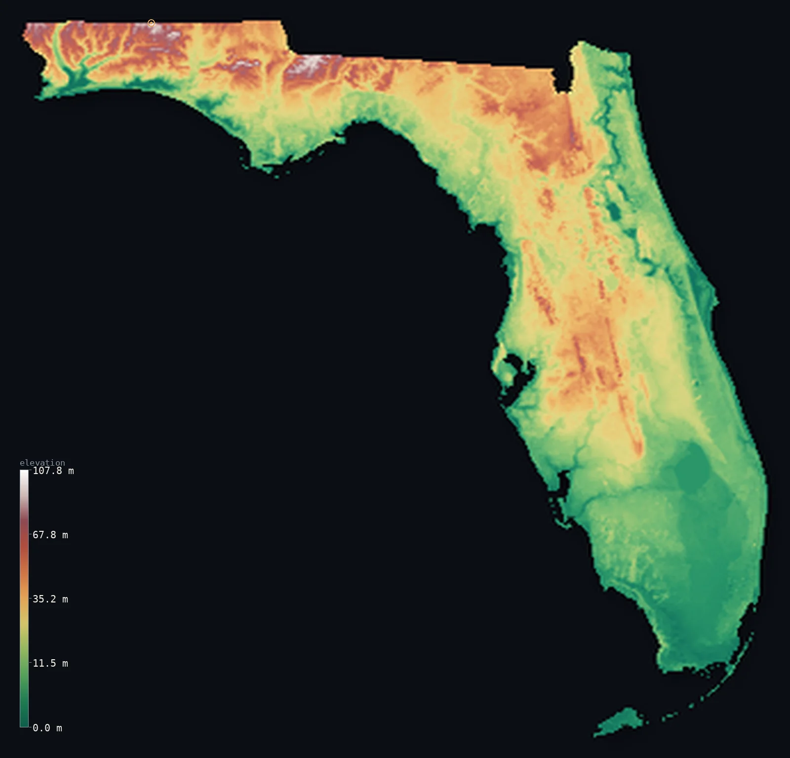
Florida’s highest point is Britton Hill at 344 ft (105 m); its lowest is Atlantic Ocean at 0 ft (0 m); the mean elevation is 70 ft (21.3 m).
- Highest point📚
- 344 ft105 m
- Britton Hill in the Panhandle - the lowest state high point in the US.
- Lowest point📚
- 0 ft0 m
- Sea level around the long coastline.
- Mean elevation⚙
- 70 ft21.3 m
- Computed from the GLO-30 surface model across the state.
- Median elevation⚙
- 57 ft17.4 m
- Half of Florida lies below this height.
- Elevation range📚
- 344 ft105 m
- From the sea to Britton Hill's mere 105 m.
- Above 50 m (164 ft)⚙
- 8%
- The low Panhandle hills and the central ridge.
- Official area📚
- 65,758 mi²170,312 km²
- A low, flat peninsula and Panhandle on a limestone platform.
Florida at a glance
Britton Hill, at 105 m, is the lowest high point of any US state - lower than some buildings.
source ↗Florida is the flattest state in the nation, with a mean elevation of only about 30 m.
source ↗The Lake Wales Ridge is an ancient chain of dune islands from times of higher seas.
source ↗The Everglades is a vast, slow-moving river of grass only centimetres deep over wide areas.
source ↗Florida's limestone base is riddled with sinkholes, springs and underground caverns.
source ↗
Elevation profile of Florida
The largest share of land, 35%, falls in the 0–10 m band, and 100% of the territory lies below 500 m (1,640 ft).
- 0–10 m (0–33 ft)35%
- 10–50 m (33–164 ft)57%
- above 50 m (164 ft)8%
Highest and lowest points
The highest point of Florida, Britton Hill, just 105 m, in the Panhandle near the Alabama border - the lowest state high point in the entire United States. It is a gentle wooded rise with a small monument, reflecting Florida's setting on a flat limestone platform barely above the sea.
source ↗Highest peaks of Florida
Terrain regions of Florida
Britton Hill, at 105 m, is the lowest high point of any US state - lower than some buildings. ↗
The Panhandle
↗The narrow northwestern strip along the Gulf and Alabama border, with the state's highest - if still modest - ground of red-clay hills.
The central ridge
↗The sandy spine of low hills running down the middle of the peninsula, the Lake Wales Ridge and its lakes.
The coastal lowlands and Everglades
↗The flat coastal plains ringing the peninsula and the vast wetland of the Everglades in the south, all barely above sea level.
The Panhandle uplands
the northwestThe narrow northwestern Panhandle holds Florida's highest ground - though 'highest' is relative here. Rolling red-clay hills near the Alabama border rise to Britton Hill at just 105 m, the lowest state high point in the entire country. This is the only part of Florida with any real relief, an extension of the low uplands of southern Alabama and Georgia.
The central peninsular ridge
the central peninsulaDown the spine of the peninsula runs a belt of low sandy ridges, most notably the Lake Wales Ridge, an ancient chain of dune islands from higher sea levels. It carries Florida's peninsular high point, Sugarloaf Mountain (95 m), and thousands of lakes and sinkholes in the porous limestone karst beneath.
The coastal lowlands and Everglades
most of the stateMost of Florida is flat, low coastal lowland only a few metres above the sea - pine flatwoods, marsh, barrier islands and beaches ringing the peninsula. In the south lies the Everglades, a vast, almost level river of grass draining slowly toward the sea, and the low Florida Keys curving out into the Gulf. Nearly all of it stands barely above high tide, making Florida among the most exposed states to sea-level rise.
City elevations in Florida
| City | Population | Elevation |
|---|---|---|
| Jacksonville | 1,009,833 | 20 ft6 m |
| MiamiMiami sits on the flat southeastern coast, only a few metres above sea level beside the Everglades. ↗ | 487,014 | 23 ft7 m |
| Tampa | 414,547 | 26 ft8 m |
| Orlando | 334,854 | 115 ft35 m |
| TallahasseeTallahassee, the capital, lies in the rolling red-clay hills of the northern Panhandle - among the highest ground in the state. ↗ | 201,731 | 210 ft64 m |
| Cape Coral | 175,229 | 10 ft3 m |
| Port Saint Lucie | 164,603 | 20 ft6 m |
| Gainesville | 145,214 | 187 ft57 m |
| West Palm Beach | 120,932 | 23 ft7 m |
| Palm Bay | 119,760 | 23 ft7 m |
Elevation sampled at each city centre from the Copernicus GLO-30 model. Cities and population from GeoNames (CC-BY 4.0).
Florida in comparison
Florida's terrain rises 344 ft (105 m) from sea level to Britton Hill — about 1% of the height of Mount Everest, the world's highest point at 29,032 ft (8,849 m).
- Georgia's mean elevation is 4,045 ft — 3,975 ft higher; its high point, Shkhara, reaches 17,037 ft (5,193 m), 16,693 ft above. Georgia elevation map →
Frequently asked questions
What is the highest point in Florida?
- Britton Hill, just 344 ft (105 m), in the Panhandle - the lowest state high point in the entire United States.
What is the average elevation of Florida?
- Only about 30 m - the lowest of any US state; this page also reports the area-weighted mean computed from the Copernicus GLO-30 model, 70 ft (21.3 m).
What is the lowest point in Florida?
- Sea level, along the Atlantic and Gulf coasts.
Is Florida the flattest state?
- Yes - with a mean elevation near 30 m and a high point of only 105 m, Florida is the flattest and lowest state in the country.
What is the highest point in peninsular Florida?
- Sugarloaf Mountain, about 95 m, on the Lake Wales Ridge - Britton Hill (105 m) is up in the Panhandle.
Is this a topographic, relief, contour, or elevation map of Florida?
- They describe the same thing - terrain height. This page renders Florida's actual elevation surface in interactive 3D (a relief or topographic view) and reports the statistics computed from it; a contour map shows the same data as lines of equal height.
About this map
The terrain is rendered from the Copernicus GLO-30 digital elevation model (ESA), masked to the US-FL boundary from geoBoundaries (gbOpen). Elevation statistics are computed directly from the model; peak names and researched facts are sourced and cited. See the methodology for the full pipeline.
This map renders 150,942 km² across 103 landmasses of Florida. 13 smaller outlying parts — 14 km² in total — lie beyond the area shown here. Area statistics above count the full territory.
Our area-weighted mean, computed from the Copernicus GLO-30 model, is 70 ft (21.3 m); the figure commonly cited elsewhere is 98 ft (30 m) (U.S. Geological Survey). Florida is the flattest and lowest state, its mean elevation only about 30 m, because it sits on a low, flat limestone platform barely above the sea; the page reports the area-weighted figure computed from the Copernicus GLO-30 model.
Surveyed national figures: official area · high point.
Rendered from Copernicus GLO-30 (ESA, 2021 release), boundaries from geoBoundaries. Generated 2026-07-13.