New Mexico Elevation Map
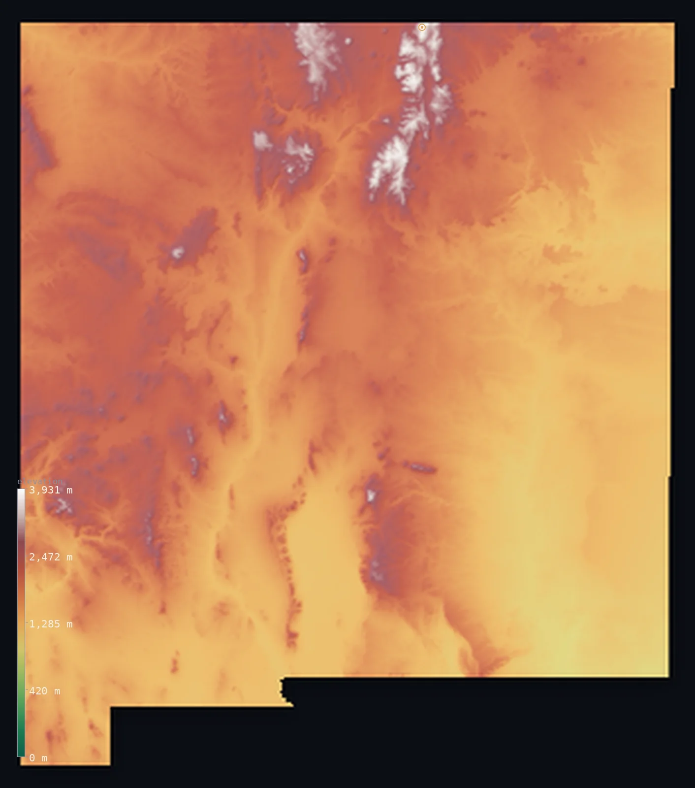
New Mexico’s highest point is Wheeler Peak at 13,166 ft (4,013 m); its lowest is Red Bluff Reservoir at 2,818 ft (859 m); the mean elevation is 5,774 ft (1,760 m).
- Highest point📚
- 13,166 ft4,013 m
- Wheeler Peak.
- Lowest point📚
- 2,818 ft859 m
- Red Bluff Reservoir.
- Mean elevation⚙
- 5,774 ft1,760 m
- Computed from the GLO-30 surface model.
- Median elevation⚙
- 5,689 ft1,734 m
- Half of New Mexico lies below this height.
- Elevation range📚
- 10,348 ft3,154 m
- From 859 m to Wheeler Peak's 4013 m.
- Above 1,000 m (3,281 ft)⚙
- 99%
- The state's main highlands.
- Above 2,000 m (6,562 ft)⚙
- 31%
- The highest ranges.
- Official area📚
- 121,590 mi²314,917 km²
- New Mexico.
New Mexico at a glance
Wheeler Peak marks the southern end of the Rocky Mountains proper.
source ↗The Rio Grande flows through an active continental rift that is slowly pulling New Mexico apart.
source ↗White Sands is the largest gypsum dune field on Earth.
source ↗New Mexico spans alpine tundra in the north and true desert in the south within a single state.
source ↗Even the state's lowest point sits at 859 m, on the high side for the American Southwest.
source ↗
Elevation profile of New Mexico
The largest share of land, 20%, falls in the 1,200–1,400 m band, and 100% of the territory lies above 500 m (1,640 ft).
- 500–1,000 m1%
- 1,000–2,000 m68%
- above 2,000 m (6,562 ft)31%
Highest and lowest points
The highest point of New Mexico, Wheeler Peak, 4,013 m, in the Sangre de Cristo Mountains near Taos - the southern end of the Rocky Mountains, where the high peaks give way to desert to the south.
source ↗Highest peaks of New Mexico
| Peak | Elevation | Range | Note |
|---|---|---|---|
| Wheeler Peak↗ | 13,166 ft4,013 m | Sangre de Cristo Mountains | Highest point of New Mexico, near Taos. |
| Truchas Peak↗ | 13,104 ft3,994 m | Sangre de Cristo Mountains | The second-highest peak in New Mexico. |
| Old Mike Peak↗ | 13,081 ft3,987 m | Sangre de Cristo Mountains | A high summit beside Wheeler Peak. |
| Sierra Blanca↗ | 11,982 ft3,652 m | Sacramento Mountains | A high peak of the southern mountains, snow-capped above the desert. |
| Mount Taylor↗ | 11,306 ft3,446 m | San Mateo Mountains | A sacred volcanic peak west of Albuquerque. |
Terrain regions of New Mexico
Wheeler Peak marks the southern end of the Rocky Mountains proper. ↗
The southern Rockies
↗Northern New Mexico is where the Rocky Mountains end. The Sangre de Cristo Range reaches down from Colorado, carrying Wheeler Peak (4,013 m) and a cluster of hi
The Rio Grande rift and central highlands
↗Down the middle of the state runs the Rio Grande, flowing through a great rift valley that splits New Mexico as the continental crust slowly pulls apart. Around
The deserts and high plains
↗Southern and eastern New Mexico is desert and plain - the Chihuahuan Desert basins of the south, dotted with isolated ranges and the white gypsum dunes of White
The southern Rockies
the northNorthern New Mexico is where the Rocky Mountains end. The Sangre de Cristo Range reaches down from Colorado, carrying Wheeler Peak (4,013 m) and a cluster of high, forested summits around Taos and Santa Fe. This is the highest, coolest, wettest part of the state, fed by winter snow.
The Rio Grande rift and central highlands
the centreDown the middle of the state runs the Rio Grande, flowing through a great rift valley that splits New Mexico as the continental crust slowly pulls apart. Around it rise isolated ranges and volcanic peaks like Mount Taylor, and the river threads past Albuquerque between desert mesas.
The deserts and high plains
the south and eastSouthern and eastern New Mexico is desert and plain - the Chihuahuan Desert basins of the south, dotted with isolated ranges and the white gypsum dunes of White Sands, and the high Llano Estacado plains of the east. The land drops to its lowest at Red Bluff Reservoir on the Texas border, at 859 m.
City elevations in New Mexico
| City | Population | Elevation |
|---|---|---|
| Albuquerque | 564,559 | 4,967 ft1,514 m |
| Las Cruces | 101,643 | 3,914 ft1,193 m |
| Santa Fe | 87,505 | 7,008 ft2,136 m |
| Roswell | 48,544 | 3,583 ft1,092 m |
| Farmington | 42,871 | 5,299 ft1,615 m |
| Clovis | 39,480 | 4,272 ft1,302 m |
| Hobbs | 38,416 | 3,629 ft1,106 m |
| Alamogordo | 30,753 | 4,341 ft1,323 m |
| Carlsbad | 28,957 | 3,114 ft949 m |
| Gallup | 23,240 | 6,512 ft1,985 m |
Elevation sampled at each city centre from the Copernicus GLO-30 model. Cities and population from GeoNames (CC-BY 4.0).
New Mexico in comparison
New Mexico's terrain rises 10,348 ft (3,154 m) from Red Bluff Reservoir (2,818 ft (859 m)) to Wheeler Peak — about 36% of the height of Mount Everest, the world's highest point at 29,032 ft (8,849 m).
Frequently asked questions
What is the highest point in New Mexico?
- Wheeler Peak, 13,166 ft (4,013 m).
What is the average elevation of New Mexico?
- About 1740 m according to the USGS; this page also reports the area-weighted mean computed from the Copernicus GLO-30 model, 5,774 ft (1,760 m).
What is the lowest point in New Mexico?
- Red Bluff Reservoir, 2,818 ft (859 m).
Wheeler Peak marks the southern end of the Rocky Mountains proper?
- Wheeler Peak marks the southern end of the Rocky Mountains proper.
Where is the highest ground in New Mexico?
- Northern New Mexico is where the Rocky Mountains end. The Sangre de Cristo Range reaches down from Colorado, carrying Wheeler Peak (4,013 m) and a cluster of high, forested summits around Taos and San
Is this a topographic, relief, contour, or elevation map of New Mexico?
- They describe the same thing - terrain height. This page renders New Mexico's actual elevation surface in interactive 3D (a relief or topographic view) and reports the statistics computed from it; a contour map shows the same data as lines of equal height.
About this map
The terrain is rendered from the Copernicus GLO-30 digital elevation model (ESA), masked to the US-NM boundary from geoBoundaries (gbOpen). Elevation statistics are computed directly from the model; peak names and researched facts are sourced and cited. See the methodology for the full pipeline.
Our area-weighted mean, computed from the Copernicus GLO-30 model, is 5,774 ft (1,760 m); the figure commonly cited elsewhere is 5,709 ft (1,740 m) (U.S. Geological Survey). New Mexico's mean elevation is about 1740 m; the page reports the area-weighted figure computed from the Copernicus GLO-30 model.
Surveyed national figures: official area · high point.
Rendered from Copernicus GLO-30 (ESA, 2021 release), boundaries from geoBoundaries. Generated 2026-07-14.