Arizona Elevation Map
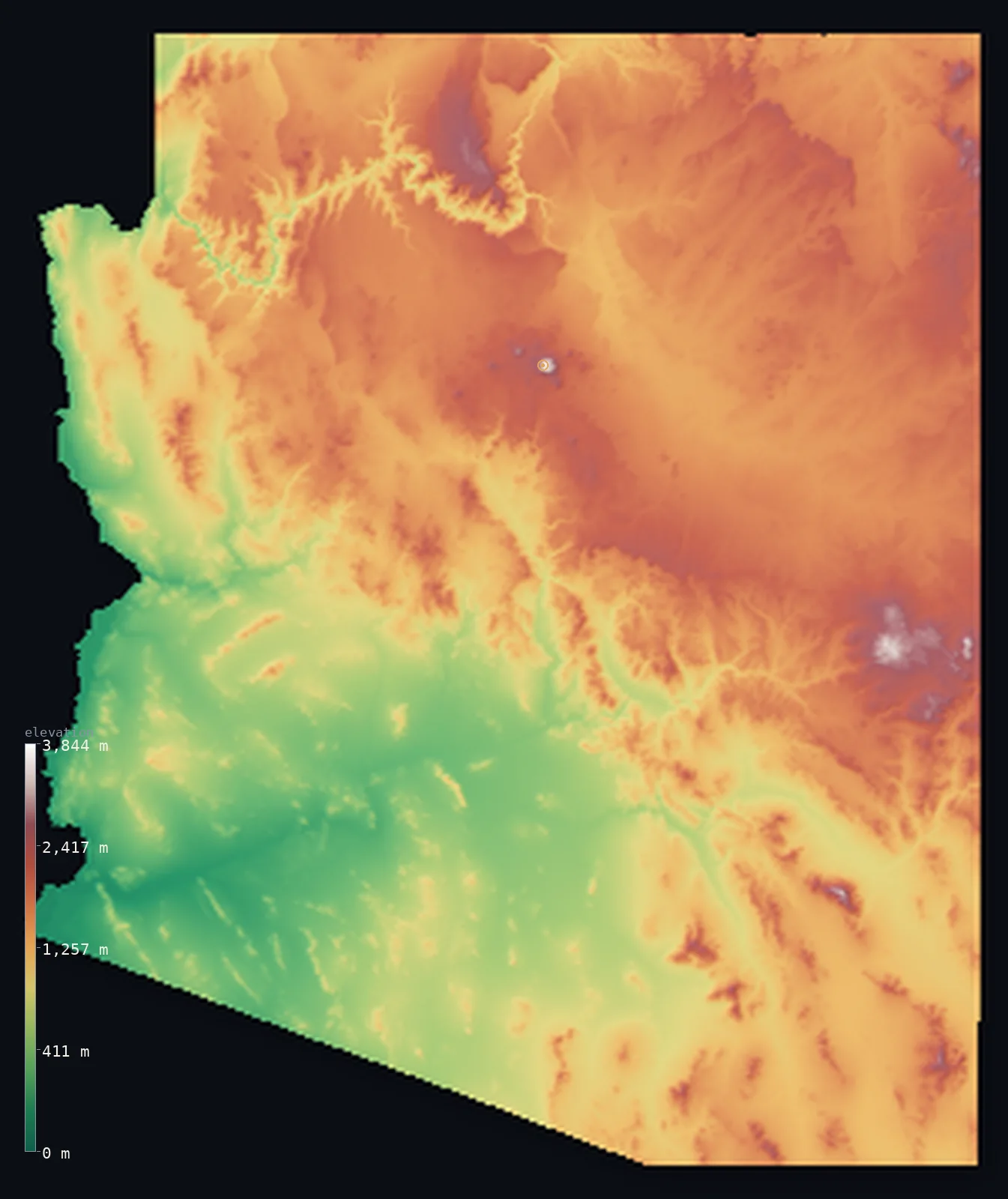
Arizona’s highest point is Humphreys Peak at 12,638 ft (3,852 m); its lowest is Colorado River at 72 ft (22 m); the mean elevation is 4,216 ft (1,285 m).
- Highest point📚
- 12,638 ft3,852 m
- Humphreys Peak, in the San Francisco Peaks near Flagstaff.
- Lowest point📚
- 72 ft22 m
- The Colorado River in the southwest, about 22 m.
- Mean elevation⚙
- 4,216 ft1,285 m
- Computed from the GLO-30 surface model across the state.
- Median elevation⚙
- 4,596 ft1,401 m
- Half of Arizona lies below this height.
- Elevation range📚
- 12,566 ft3,830 m
- From 22 m on the Colorado River to Humphreys's 3,852 m.
- Above 1,000 m (3,281 ft)⚙
- 66%
- The Colorado Plateau and the central mountains.
- Above 2,000 m (6,562 ft)⚙
- 11%
- The San Francisco Peaks and the White Mountains.
- Official area📚
- 113,990 mi²295,234 km²
- A state of high northern plateau, central mountains and southern desert.
Arizona at a glance
Humphreys Peak is the eroded core of an extinct volcano and rises high enough for alpine tundra.
source ↗The Grand Canyon, cut a mile deep by the Colorado River, crosses the northern plateau.
source ↗Arizona spans nearly 3,800 m of relief, from Sonoran Desert to alpine peak.
source ↗The Mogollon Rim is a 600 m escarpment splitting the high plateau from the low desert.
source ↗The state holds some of the largest continuous ponderosa pine forests on Earth.
source ↗
Elevation profile of Arizona
The largest share of land, 18%, falls in the 1,500–1,750 m band, and 84% of the territory lies above 500 m (1,640 ft).
- below 500 m (1,640 ft)16%
- 500–1,000 m18%
- 1,000–2,000 m55%
- above 2,000 m (6,562 ft)11%
Highest and lowest points
The highest point of Arizona, Humphreys Peak, 3,852 m, the apex of the San Francisco Peaks just north of Flagstaff. The peaks are the eroded remnant of a large extinct stratovolcano, and Humphreys rises high enough to hold alpine tundra above the surrounding Colorado Plateau.
source ↗Highest peaks of Arizona
| Peak | Elevation | Range | Note |
|---|---|---|---|
| Humphreys Peak↗ | 12,638 ft3,852 m | San Francisco Peaks | Highest point of Arizona, an extinct volcano north of Flagstaff. |
| Agassiz Peak↗ | 12,356 ft3,766 m | San Francisco Peaks | The second-highest peak in Arizona, beside Humphreys. |
| Fremont Peak↗ | 11,860 ft3,615 m | San Francisco Peaks | Another summit of the San Francisco Peaks volcanic complex. |
| Mount Baldy↗ | 11,404 ft3,476 m | White Mountains | The high point of the volcanic White Mountains in eastern Arizona. |
| Escudilla Mountain↗ | 10,023 ft3,055 m | White Mountains | The third-highest mountain in Arizona, in the far east. |
Terrain regions of Arizona
Humphreys Peak is the eroded core of an extinct volcano and rises high enough for alpine tundra. ↗
The Colorado Plateau
↗The high plateau of northern Arizona - canyons, mesas and the San Francisco Peaks - cut by the Grand Canyon of the Colorado River.
The central highlands
↗The transition belt of the Mogollon Rim and central mountains dividing the plateau from the desert.
The basin and range deserts
↗The low Sonoran Desert of the south and west - broad desert basins between isolated mountain ranges, holding Phoenix and Tucson.
The Colorado Plateau
the northNorthern Arizona is high plateau country - the Colorado Plateau, a vast tableland generally above 1,500 m of horizontal rock layers, mesas and deep canyons. The Colorado River has carved the Grand Canyon a mile deep across it, and rising above it stand the San Francisco Peaks, remnants of an extinct volcano, whose summit Humphreys Peak (3,852 m) is the highest point in the state.
The Mogollon Rim and central highlands
the centreSlicing diagonally across the state is the Mogollon Rim, a great escarpment up to 600 m high where the Colorado Plateau drops away to lower country. Along and below it lies a belt of central mountains and forested highlands - the transition zone between the high north and the low desert south, including some of the largest ponderosa pine forests in the world.
The basin and range deserts
the south and westSouthern and western Arizona is basin-and-range desert - broad, flat desert basins separated by short, steep, isolated mountain ranges. This is the Sonoran Desert, low and hot, dropping to the state's lowest point at 22 m where the Colorado River leaves the southwestern corner. It holds Phoenix and Tucson and the saguaro cactus country.
City elevations in Arizona
| City | Population | Elevation |
|---|---|---|
| PhoenixPhoenix, the capital, spreads across the low Sonoran Desert basin of the south-centre at about 340 m. ↗ | 1,650,070 | 1,096 ft334 m |
| Tucson | 542,629 | 2,484 ft757 m |
| Yuma | 95,548 | 141 ft43 m |
| San Tan Valley | 81,321 | 1,519 ft463 m |
| Agua Prieta | 77,254 | 4,012 ft1,223 m |
| FlagstaffFlagstaff sits high on the Colorado Plateau at about 2,100 m, below the San Francisco Peaks. ↗ | 70,320 | 6,903 ft2,104 m |
| Lake Havasu City | 53,553 | 741 ft226 m |
| Sierra Vista | 43,355 | 4,639 ft1,414 m |
| Prescott Valley | 42,197 | 5,013 ft1,528 m |
| Bullhead City | 39,445 | 554 ft169 m |
Elevation sampled at each city centre from the Copernicus GLO-30 model. Cities and population from GeoNames (CC-BY 4.0).
Arizona in comparison
Arizona's terrain rises 12,566 ft (3,830 m) from Colorado River (72 ft (22 m)) to Humphreys Peak — about 43% of the height of Mount Everest, the world's highest point at 29,032 ft (8,849 m).
Frequently asked questions
What is the highest point in Arizona?
- Humphreys Peak, 12,638 ft (3,852 m), in the San Francisco Peaks just north of Flagstaff - an extinct volcano.
What is the average elevation of Arizona?
- About 1,250 m according to the USGS; this page also reports the area-weighted mean computed from the Copernicus GLO-30 model, 4,216 ft (1,285 m).
What is the lowest point in Arizona?
- The Colorado River in the southwest, 72 ft (22 m).
Is Arizona all desert?
- No - the south is Sonoran Desert, but the north is high plateau above 1,500 m with forests and peaks, including alpine tundra on Humphreys Peak.
Where is the Grand Canyon?
- On the Colorado Plateau of northern Arizona, where the Colorado River has cut a canyon over a mile deep.
Is this a topographic, relief, contour, or elevation map of Arizona?
- They describe the same thing - terrain height. This page renders Arizona's actual elevation surface in interactive 3D (a relief or topographic view) and reports the statistics computed from it; a contour map shows the same data as lines of equal height.
About this map
The terrain is rendered from the Copernicus GLO-30 digital elevation model (ESA), masked to the US-AZ boundary from geoBoundaries (gbOpen). Elevation statistics are computed directly from the model; peak names and researched facts are sourced and cited. See the methodology for the full pipeline.
Our area-weighted mean, computed from the Copernicus GLO-30 model, is 4,216 ft (1,285 m); the figure commonly cited elsewhere is 4,101 ft (1,250 m) (U.S. Geological Survey). Arizona rises from the low deserts of the southwest to the high Colorado Plateau of the north, giving a fairly high mean of about 1,250 m; the page reports the area-weighted figure computed from the Copernicus GLO-30 model.
Surveyed national figures: official area · high point.
Rendered from Copernicus GLO-30 (ESA, 2021 release), boundaries from geoBoundaries. Generated 2026-07-13.