California Elevation Map
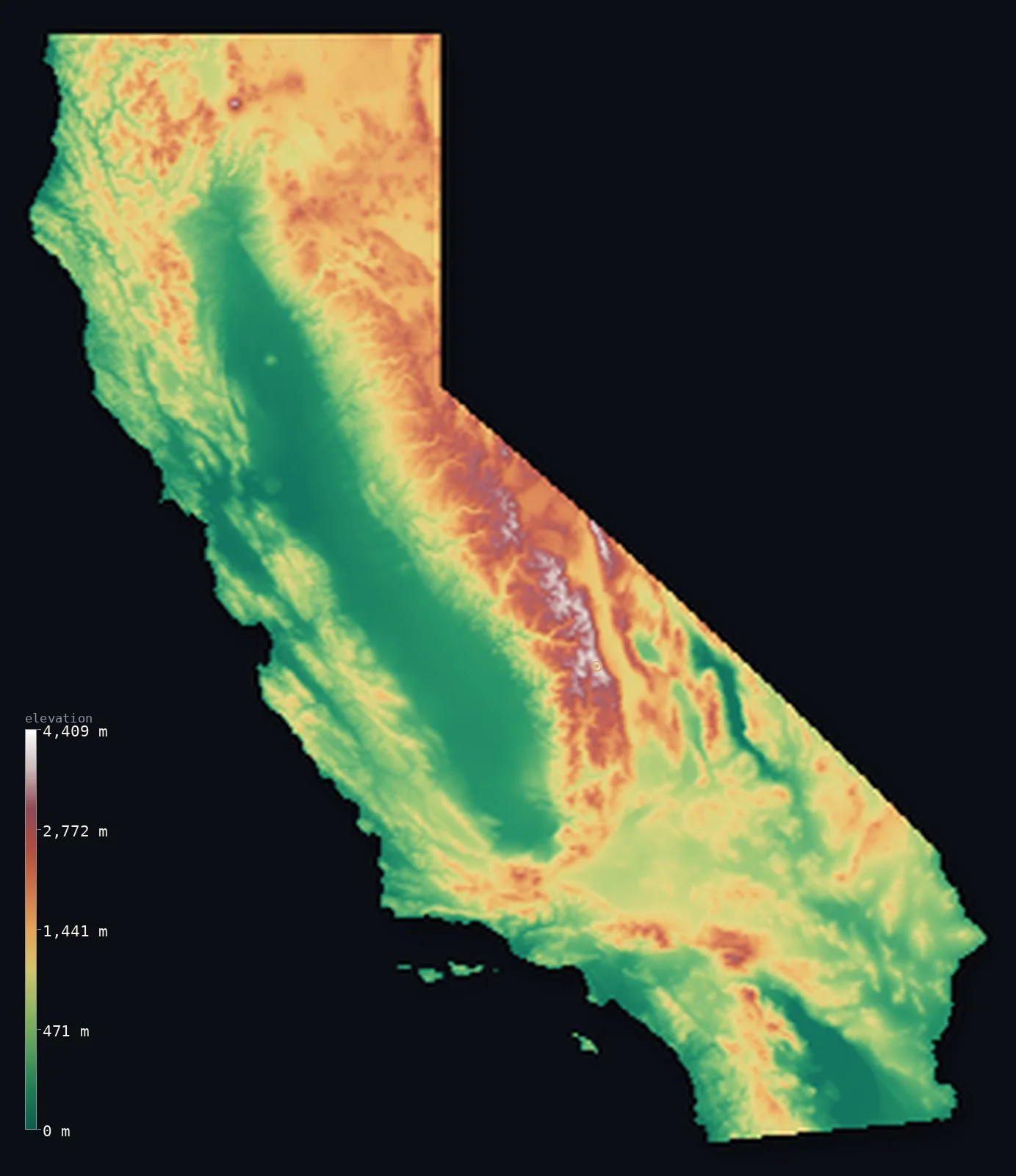
California’s highest point is Mount Whitney at 14,505 ft (4,421 m); its lowest is Badwater Basin, Death Valley at −282 ft (−86 m); the mean elevation is 2,802 ft (854 m).
- Highest point📚
- 14,505 ft4,421 m
- Mount Whitney, in the Sierra Nevada of the east.
- Lowest point📚
- −282 ft−86 m
- Badwater Basin in Death Valley, 86 m below sea level.
- Mean elevation⚙
- 2,802 ft854 m
- Computed from the GLO-30 surface model across the state.
- Median elevation⚙
- 2,300 ft701 m
- Half of California lies below this height.
- Elevation range📚
- 14,787 ft4,507 m
- From −282 ft (−86 m) at Badwater Basin to Whitney's 4,421 m.
- Above 1,000 m (3,281 ft)⚙
- 36%
- The Sierra Nevada and the coastal and Transverse ranges.
- Above 2,000 m (6,562 ft)⚙
- 8%
- The high Sierra Nevada of the east.
- Official area📚
- 163,696 mi²423,970 km²
- A large, varied state of high mountains, valleys, coast and desert.
California at a glance
California holds both the highest point in the contiguous US (Whitney) and the lowest in North America (Badwater), just 135 km apart.
source ↗Badwater Basin in Death Valley sits 86 m below sea level and is the hottest place ever recorded on Earth.
source ↗The White Mountains, just east of the Sierra, hold the oldest living trees on the planet - bristlecone pines.
source ↗Mount Shasta is a glaciated volcano rising more than 3,000 m above the surrounding country.
source ↗The Central Valley is so flat that it drops only a few metres over hundreds of kilometres.
source ↗
Elevation profile of California
The largest share of land, 38%, falls in the 0–500 m band, and 60% of the territory lies above 500 m (1,640 ft).
- below 500 m (1,640 ft)40%
- 500–1,000 m24%
- 1,000–2,000 m28%
- above 2,000 m (6,562 ft)8%
Highest and lowest points
The highest point of California, Mount Whitney, 4,421 m, the highest summit in the Sierra Nevada and in the entire contiguous United States. Remarkably, it stands only about 135 km from Badwater Basin in Death Valley, the lowest point in North America - the greatest high-to-low contrast in the country.
source ↗Highest peaks of California
| Peak | Elevation | Range | Note |
|---|---|---|---|
| Mount Whitney↗ | 14,505 ft4,421 m | Sierra Nevada | Highest point of California and of the contiguous US. |
| Mount Williamson↗ | 14,380 ft4,383 m | Sierra Nevada | The second-highest peak in California, near Whitney. |
| White Mountain Peak↗ | 14,252 ft4,344 m | White Mountains | The third-highest peak in the state, east of the Sierra across the Owens Valley. |
| Mount Shasta↗ | 14,180 ft4,322 m | Cascade Range | A massive glaciated stratovolcano dominating far northern California. |
| Mount Dana↗ | 13,061 ft3,981 m | Sierra Nevada | A high peak on the eastern boundary of Yosemite National Park. |
Terrain regions of California
California holds both the highest point in the contiguous US (Whitney) and the lowest in North America (Badwater), just 135 km apart. ↗
The Sierra Nevada and eastern ranges
↗The great granite wall of the Sierra Nevada with Mount Whitney, and the arid ranges and basins east of it, including the White Mountains and Death Valley.
The Central Valley and coast ranges
↗The long, flat Central Valley down the middle of the state, flanked by the Coast Ranges that meet the Pacific.
The south and the deserts
↗The Transverse and Peninsular ranges around Los Angeles, and the Mojave and Colorado deserts of the southeast.
The Sierra Nevada and eastern deserts
the eastCalifornia's eastern spine is the Sierra Nevada, a long, tilted block of granite rising in a gentle western slope and a sheer eastern escarpment. It culminates in Mount Whitney (4,421 m), the highest point in the contiguous United States. Immediately east, across the deep Owens Valley, the land plunges into the below-sea-level basins of Death Valley, where Badwater sits 86 m below the ocean - the lowest, hottest, driest place in North America.
The Central Valley and Coast Ranges
the centre and coastDown the middle of the state runs the Central Valley, a vast, flat alluvial trough that is one of the most productive farming regions on Earth. Between it and the Pacific rise the Coast Ranges, a series of parallel folded ridges and valleys running the length of the state, cut by San Francisco Bay where the valley's rivers reach the sea.
The northern mountains and the south
the north and southIn the far north the Sierra and Coast ranges merge into the volcanic Cascades - crowned by Mount Shasta - and the rugged Klamath Mountains. In the south, the Transverse and Peninsular ranges wrap around the Los Angeles and San Diego basins, giving way inland to the Mojave and Colorado deserts of the southeastern corner.
City elevations in California
| City | Population | Elevation |
|---|---|---|
| Los AngelesLos Angeles spreads across a coastal basin in the south, ringed by the Transverse Ranges. ↗ | 3,820,914 | 302 ft92 m |
| San Diego | 1,404,452 | 39 ft12 m |
| San Jose | 997,368 | 89 ft27 m |
| Fresno | 542,107 | 315 ft96 m |
| SacramentoSacramento, the state capital, lies in the flat Central Valley between the coastal ranges and the Sierra Nevada. ↗ | 524,943 | 46 ft14 m |
| Bakersfield | 373,640 | 410 ft125 m |
| Moreno Valley | 204,198 | 1,634 ft498 m |
| Santa Rosa | 178,127 | 177 ft54 m |
| Chico | 121,345 | 207 ft63 m |
| Santa Maria | 105,093 | 223 ft68 m |
Elevation sampled at each city centre from the Copernicus GLO-30 model. Cities and population from GeoNames (CC-BY 4.0).
California in comparison
California's terrain rises 14,787 ft (4,507 m) from Badwater Basin, Death Valley, 282 ft (86 m) below sea level to Mount Whitney — about 51% of the height of Mount Everest, the world's highest point at 29,032 ft (8,849 m).
Frequently asked questions
What is the highest point in California?
- Mount Whitney, 14,505 ft (4,421 m), in the Sierra Nevada - the highest summit in the contiguous United States.
What is the average elevation of California?
- About 880 m according to the USGS; this page also reports the area-weighted mean computed from the Copernicus GLO-30 model, 2,802 ft (854 m).
What is the lowest point in California?
- Badwater Basin in Death Valley, −282 ft (−86 m) - the lowest point in all of North America.
How can Whitney and Death Valley be so close?
- The Sierra Nevada is a rising fault block while Death Valley is a sinking one, so the highest and lowest points in the contiguous US sit only about 135 km apart.
Is California mountainous?
- Much of it - the Sierra Nevada, Cascades, Klamath and Coast Ranges - though the Central Valley and southeastern deserts are low and flat.
Is this a topographic, relief, contour, or elevation map of California?
- They describe the same thing - terrain height. This page renders California's actual elevation surface in interactive 3D (a relief or topographic view) and reports the statistics computed from it; a contour map shows the same data as lines of equal height.
About this map
The terrain is rendered from the Copernicus GLO-30 digital elevation model (ESA), masked to the US-CA boundary from geoBoundaries (gbOpen). Elevation statistics are computed directly from the model; peak names and researched facts are sourced and cited. See the methodology for the full pipeline.
This map renders 409,671 km² across 11 landmasses of California. 2 smaller outlying parts — 209 km² in total — lie beyond the area shown here. Area statistics above count the full territory.
Our area-weighted mean, computed from the Copernicus GLO-30 model, is 2,802 ft (854 m); the figure commonly cited elsewhere is 2,887 ft (880 m) (U.S. Geological Survey). California spans the high Sierra Nevada, the Central Valley, the coastal ranges and the below-sea-level deserts, giving a moderate mean of about 880 m; the page reports the area-weighted figure computed from the Copernicus GLO-30 model.
Surveyed national figures: official area · high point.
Rendered from Copernicus GLO-30 (ESA, 2021 release), boundaries from geoBoundaries. Generated 2026-07-13.