Oregon Elevation Map
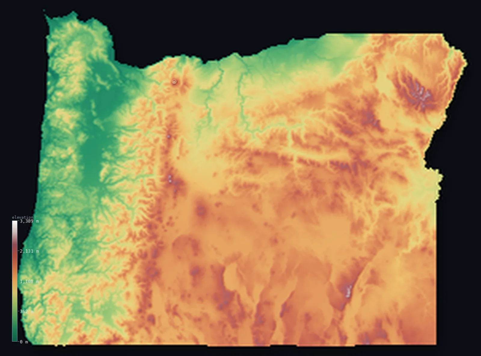
Oregon’s highest point is Mount Hood at 11,250 ft (3,429 m); its lowest is Pacific Ocean at 0 ft (0 m); the mean elevation is 3,533 ft (1,077 m).
- Highest point📚
- 11,250 ft3,429 m
- Mount Hood.
- Lowest point📚
- 0 ft0 m
- Pacific Ocean.
- Mean elevation⚙
- 3,533 ft1,077 m
- Computed from the GLO-30 surface model.
- Median elevation⚙
- 4,039 ft1,231 m
- Half of Oregon lies below this height.
- Elevation range📚
- 11,250 ft3,429 m
- From 0 m to Mount Hood's 3429 m.
- Above 1,000 m (3,281 ft)⚙
- 61%
- The state's main highlands.
- Above 2,000 m (6,562 ft)⚙
- 2%
- The highest ranges.
- Official area📚
- 98,378 mi²254,799 km²
- Oregon.
Oregon at a glance
Crater Lake, in a collapsed Cascade volcano, is the deepest lake in the United States.
source ↗Mount Hood carries glaciers year-round despite being a short drive from Portland.
source ↗The Cascades split Oregon into a wet, green west and a dry, high-desert east.
source ↗Crater Lake, at 594 m deep, is the deepest lake in the United States and one of the clearest in the world.
source ↗Hells Canyon on Oregon's eastern border is the deepest river gorge in North America, deeper than the Grand Canyon.
source ↗
Elevation profile of Oregon
The largest share of land, 26%, falls in the 1,250–1,500 m band, and 80% of the territory lies above 500 m (1,640 ft).
- below 500 m (1,640 ft)20%
- 500–1,000 m19%
- 1,000–2,000 m60%
- above 2,000 m (6,562 ft)2%
Highest and lowest points
Highest peaks of Oregon
| Peak | Elevation | Range | Note |
|---|---|---|---|
| Mount Hood↗ | 11,250 ft3,429 m | Cascade Range | Highest point of Oregon, a glaciated volcano near Portland. |
| Mount Jefferson↗ | 10,495 ft3,199 m | Cascade Range | The second-highest peak in Oregon, a rugged volcano. |
| South Sister↗ | 10,364 ft3,159 m | Cascade Range | The highest of the Three Sisters volcanoes. |
| North Sister↗ | 10,085 ft3,074 m | Cascade Range | An eroded, craggy Three Sisters volcano. |
| Steens Mountain↗ | 9,734 ft2,967 m | Basin and Range | A great fault-block mountain rising from the southeastern desert. |
Terrain regions of Oregon
Crater Lake, in a collapsed Cascade volcano, is the deepest lake in the United States. ↗
The Coast Range and Willamette Valley
↗Western Oregon meets the Pacific along the forested Coast Range, behind which lies the broad, fertile Willamette Valley - the green, rainy heart of the state wh
The Cascade Range
↗Down the middle of the state runs the Cascade Range, a high volcanic spine of glaciated peaks led by Mount Hood (3,429 m), Jefferson and the Three Sisters, and
The high desert and eastern ranges
↗Eastern Oregon, in the Cascade rain shadow, is high desert - the sagebrush plateaus and fault-block ranges of the Great Basin's northern edge, the Columbia Plat
The Coast Range and Willamette Valley
the westWestern Oregon meets the Pacific along the forested Coast Range, behind which lies the broad, fertile Willamette Valley - the green, rainy heart of the state where most Oregonians live, between the coastal hills and the Cascades.
The Cascade Range
the centreDown the middle of the state runs the Cascade Range, a high volcanic spine of glaciated peaks led by Mount Hood (3,429 m), Jefferson and the Three Sisters, and holding Crater Lake, the deepest lake in the United States, in the caldera of a collapsed volcano. The range splits wet west from dry east.
The high desert and eastern ranges
the eastEastern Oregon, in the Cascade rain shadow, is high desert - the sagebrush plateaus and fault-block ranges of the Great Basin's northern edge, the Columbia Plateau's wheatlands in the north, and the Blue and Wallowa mountains rising in the northeast.
City elevations in Oregon
| City | Population | Elevation |
|---|---|---|
| Portland | 652,503 | 46 ft14 m |
| Eugene | 176,654 | 430 ft131 m |
| Salem | 175,535 | 164 ft50 m |
| Bend | 87,014 | 3,632 ft1,107 m |
| Medford | 79,805 | 1,381 ft421 m |
| Roseburg | 22,114 | 482 ft147 m |
| Klamath Falls | 21,399 | 4,114 ft1,254 m |
| Hermiston | 17,201 | 459 ft140 m |
| Coos Bay | 16,182 | 13 ft4 m |
| The Dalles | 15,340 | 266 ft81 m |
Elevation sampled at each city centre from the Copernicus GLO-30 model. Cities and population from GeoNames (CC-BY 4.0).
Oregon in comparison
Oregon's terrain rises 11,250 ft (3,429 m) from sea level to Mount Hood — about 39% of the height of Mount Everest, the world's highest point at 29,032 ft (8,849 m).
Frequently asked questions
What is the highest point in Oregon?
- Mount Hood, 11,250 ft (3,429 m).
What is the average elevation of Oregon?
- About 1000 m according to the USGS; this page also reports the area-weighted mean computed from the Copernicus GLO-30 model, 3,533 ft (1,077 m).
What is the lowest point in Oregon?
- Pacific Ocean, 0 ft (0 m).
Crater Lake, in a collapsed Cascade volcano, is the deepest lake in the United States?
- Crater Lake, in a collapsed Cascade volcano, is the deepest lake in the United States.
Where is the highest ground in Oregon?
- Western Oregon meets the Pacific along the forested Coast Range, behind which lies the broad, fertile Willamette Valley - the green, rainy heart of the state where most Oregonians live, between the co
Is this a topographic, relief, contour, or elevation map of Oregon?
- They describe the same thing - terrain height. This page renders Oregon's actual elevation surface in interactive 3D (a relief or topographic view) and reports the statistics computed from it; a contour map shows the same data as lines of equal height.
About this map
The terrain is rendered from the Copernicus GLO-30 digital elevation model (ESA), masked to the US-OR boundary from geoBoundaries (gbOpen). Elevation statistics are computed directly from the model; peak names and researched facts are sourced and cited. See the methodology for the full pipeline.
Our area-weighted mean, computed from the Copernicus GLO-30 model, is 3,533 ft (1,077 m); the figure commonly cited elsewhere is 3,281 ft (1,000 m) (U.S. Geological Survey). Oregon's mean elevation is about 1000 m; the page reports the area-weighted figure computed from the Copernicus GLO-30 model.
Surveyed national figures: official area · high point.
Rendered from Copernicus GLO-30 (ESA, 2021 release), boundaries from geoBoundaries. Generated 2026-07-13.