Idaho Elevation Map
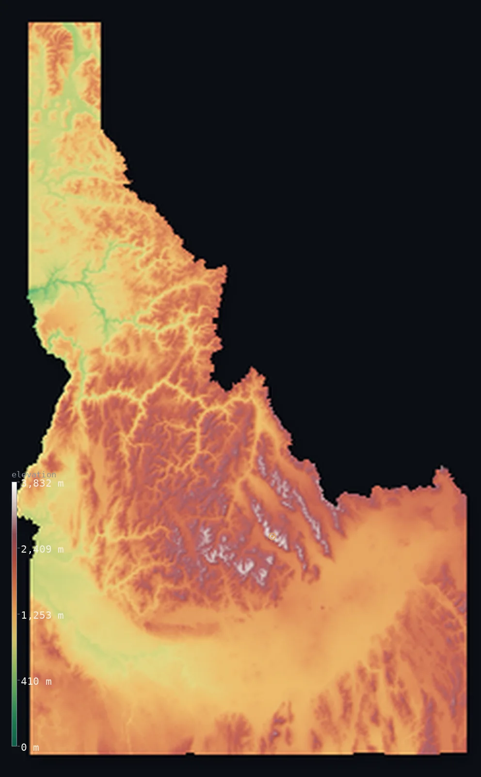
Idaho’s highest point is Borah Peak at 12,661 ft (3,859 m); its lowest is Lewiston (Snake River) at 709 ft (216 m); the mean elevation is 5,240 ft (1,597 m).
- Highest point📚
- 12,661 ft3,859 m
- Borah Peak.
- Lowest point📚
- 709 ft216 m
- Lewiston (Snake River).
- Mean elevation⚙
- 5,240 ft1,597 m
- Computed from the GLO-30 surface model.
- Median elevation⚙
- 5,177 ft1,578 m
- Half of Idaho lies below this height.
- Elevation range📚
- 11,952 ft3,643 m
- From 216 m to Borah Peak's 3859 m.
- Above 1,000 m (3,281 ft)⚙
- 85%
- The state's main highlands.
- Above 2,000 m (6,562 ft)⚙
- 21%
- The highest ranges.
- Official area📚
- 83,569 mi²216,443 km²
- Idaho.
Idaho at a glance
Borah Peak rose about 30 cm in seconds during the 1983 Borah Peak earthquake.
source ↗Hells Canyon, on Idaho's border, is the deepest river gorge in North America.
source ↗Idaho holds the largest contiguous wilderness area in the contiguous United States.
source ↗Craters of the Moon is a vast, eerie lava field once used to train Apollo astronauts.
source ↗The Snake River carves a great arc across the state before plunging through Hells Canyon.
source ↗
Elevation profile of Idaho
The largest share of land, 20%, falls in the 1,500–1,750 m band, and >99% of the territory lies above 500 m (1,640 ft).
- below 500 m (1,640 ft)<1%
- 500–1,000 m14%
- 1,000–2,000 m64%
- above 2,000 m (6,562 ft)21%
Highest and lowest points
Highest peaks of Idaho
| Peak | Elevation | Range | Note |
|---|---|---|---|
| Borah Peak↗ | 12,661 ft3,859 m | Lost River Range | Highest point of Idaho, which grew in the 1983 quake. |
| Leatherman Peak↗ | 12,205 ft3,720 m | Lost River Range | The second-highest peak in Idaho. |
| Diamond Peak↗ | 12,201 ft3,719 m | Lemhi Range | The high point of the Lemhi Range. |
| Hyndman Peak↗ | 12,077 ft3,681 m | Pioneer Mountains | The highest peak of the Pioneer Mountains near Sun Valley. |
| Mount Church↗ | 12,041 ft3,670 m | Lost River Range | A high summit of the Lost River Range. |
Terrain regions of Idaho
Borah Peak rose about 30 cm in seconds during the 1983 Borah Peak earthquake. ↗
The central mountains
↗Idaho's heart is a vast, rugged mountain wilderness - the Sawtooth, Lost River, Salmon River and Clearwater ranges, cut by some of the deepest canyons and wilde
Hells Canyon and the west
↗Along the western border the Snake River has carved Hells Canyon, the deepest river gorge in North America, deeper even than the Grand Canyon. The Snake also lo
The Snake River Plain and southeast
↗A great curving arc of low volcanic plain, the Snake River Plain, sweeps across southern Idaho - farmland watered from the river, with stark lava fields like Cr
The central mountains
the centreIdaho's heart is a vast, rugged mountain wilderness - the Sawtooth, Lost River, Salmon River and Clearwater ranges, cut by some of the deepest canyons and wildest rivers in the country. Borah Peak (3,859 m) in the Lost River Range is the summit, and the region holds the largest roadless wilderness in the lower 48.
Hells Canyon and the west
the westAlong the western border the Snake River has carved Hells Canyon, the deepest river gorge in North America, deeper even than the Grand Canyon. The Snake also loops across southern Idaho in a broad plain, and the state's lowest point lies where it leaves at Lewiston, just 216 m.
The Snake River Plain and southeast
the southA great curving arc of low volcanic plain, the Snake River Plain, sweeps across southern Idaho - farmland watered from the river, with stark lava fields like Craters of the Moon. To the southeast the land rises again toward the ranges bordering Wyoming and Utah.
City elevations in Idaho
| City | Population | Elevation |
|---|---|---|
| Boise | 235,684 | 2,710 ft826 m |
| Idaho Falls | 59,184 | 4,708 ft1,435 m |
| Pocatello | 54,441 | 4,465 ft1,361 m |
| Coeur d'Alene | 49,122 | 2,198 ft670 m |
| Twin Falls | 47,468 | 3,737 ft1,139 m |
| Lewiston | 32,544 | 741 ft226 m |
| Conda | 21,260 | 6,191 ft1,887 m |
| Mountain Home | 13,730 | 3,146 ft959 m |
| Hailey | 8,134 | 5,328 ft1,624 m |
| Sandpoint | 7,835 | 2,103 ft641 m |
Elevation sampled at each city centre from the Copernicus GLO-30 model. Cities and population from GeoNames (CC-BY 4.0).
Idaho in comparison
Idaho's terrain rises 11,952 ft (3,643 m) from Lewiston (Snake River) (709 ft (216 m)) to Borah Peak — about 41% of the height of Mount Everest, the world's highest point at 29,032 ft (8,849 m).
Frequently asked questions
What is the highest point in Idaho?
- Borah Peak, 12,661 ft (3,859 m).
What is the average elevation of Idaho?
- About 1520 m according to the USGS; this page also reports the area-weighted mean computed from the Copernicus GLO-30 model, 5,240 ft (1,597 m).
What is the lowest point in Idaho?
- Lewiston (Snake River), 709 ft (216 m).
Borah Peak rose about 30 cm in seconds during the 1983 Borah Peak earthquake?
- Borah Peak rose about 30 cm in seconds during the 1983 Borah Peak earthquake.
Where is the highest ground in Idaho?
- Idaho's heart is a vast, rugged mountain wilderness - the Sawtooth, Lost River, Salmon River and Clearwater ranges, cut by some of the deepest canyons and wildest rivers in the country. Borah Peak (3,
Is this a topographic, relief, contour, or elevation map of Idaho?
- They describe the same thing - terrain height. This page renders Idaho's actual elevation surface in interactive 3D (a relief or topographic view) and reports the statistics computed from it; a contour map shows the same data as lines of equal height.
About this map
The terrain is rendered from the Copernicus GLO-30 digital elevation model (ESA), masked to the US-ID boundary from geoBoundaries (gbOpen). Elevation statistics are computed directly from the model; peak names and researched facts are sourced and cited. See the methodology for the full pipeline.
Our area-weighted mean, computed from the Copernicus GLO-30 model, is 5,240 ft (1,597 m); the figure commonly cited elsewhere is 4,987 ft (1,520 m) (U.S. Geological Survey). Idaho's mean elevation is about 1520 m; the page reports the area-weighted figure computed from the Copernicus GLO-30 model.
Surveyed national figures: official area · high point.
Rendered from Copernicus GLO-30 (ESA, 2021 release), boundaries from geoBoundaries. Generated 2026-07-14.