Montana Elevation Map
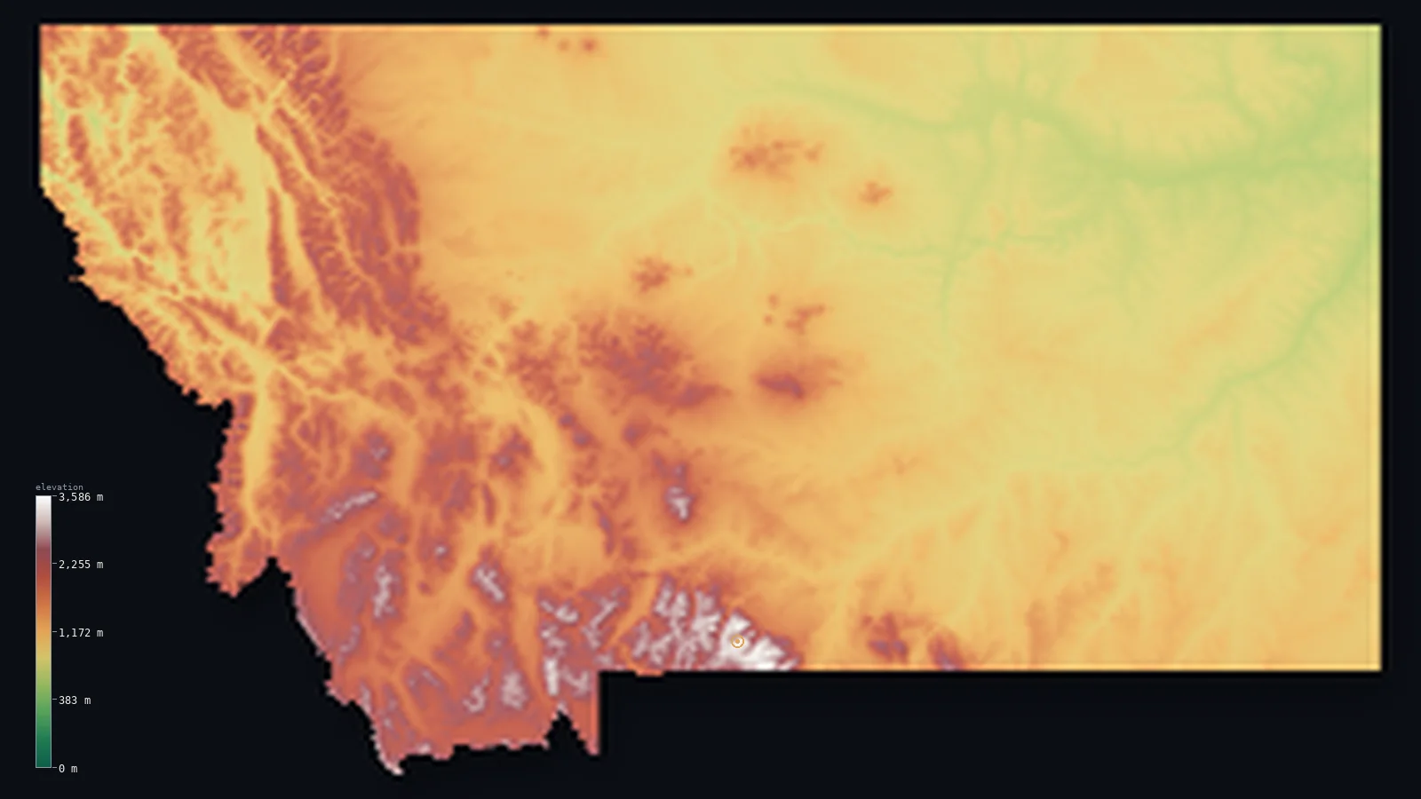
Montana’s highest point is Granite Peak at 12,808 ft (3,904 m); its lowest is Kootenai River at 1,801 ft (549 m); the mean elevation is 4,137 ft (1,261 m).
- Highest point📚
- 12,808 ft3,904 m
- Granite Peak.
- Lowest point📚
- 1,801 ft549 m
- Kootenai River.
- Mean elevation⚙
- 4,137 ft1,261 m
- Computed from the GLO-30 surface model.
- Median elevation⚙
- 3,599 ft1,097 m
- Half of Montana lies below this height.
- Elevation range📚
- 11,007 ft3,355 m
- From 549 m to Granite Peak's 3904 m.
- Above 1,000 m (3,281 ft)⚙
- 59%
- The state's main highlands.
- Above 2,000 m (6,562 ft)⚙
- 11%
- The highest ranges.
- Official area📚
- 147,040 mi²380,831 km²
- Montana.
Montana at a glance
Granite Peak was one of the last US state high points ever climbed, first summited only in 1923.
source ↗Triple Divide Peak in Glacier National Park sends water to the Pacific, Atlantic and Arctic (Hudson Bay) watersheds.
source ↗Montana is the only US state with rivers draining to three different oceans.
source ↗Glacier National Park's glacier-carved peaks are among the most rugged in the Rockies.
source ↗The state's name comes from the Spanish for 'mountain', though half of it is actually Great Plains.
source ↗
Elevation profile of Montana
The largest share of land, 32%, falls in the 750–1,000 m band, and 100% of the territory lies above 500 m (1,640 ft).
- 500–1,000 m41%
- 1,000–2,000 m49%
- above 2,000 m (6,562 ft)11%
Highest and lowest points
The highest point of Montana, Granite Peak, 3,904 m, a remote and technically difficult summit in the Beartooth Mountains - one of the last state high points to be climbed, not conquered until 1923.
source ↗Highest peaks of Montana
| Peak | Elevation | Range | Note |
|---|---|---|---|
| Granite Peak↗ | 12,808 ft3,904 m | Beartooth Mountains | Highest point of Montana, a hard technical climb. |
| Mount Wood↗ | 12,539 ft3,822 m | Beartooth Mountains | The second-highest peak in Montana. |
| Castle Mountain↗ | 12,392 ft3,777 m | Beartooth Mountains | A high Beartooth summit near Granite Peak. |
| Mount Cowen↗ | 11,224 ft3,421 m | Absaroka Range | The highest peak of the Absaroka Range. |
| Trapper Peak↗ | 10,157 ft3,096 m | Bitterroot Range | The highest peak of the Bitterroot Mountains in the west. |
Terrain regions of Montana
Granite Peak was one of the last US state high points ever climbed, first summited only in 1923. ↗
The Rocky Mountains
↗Western Montana is a tangle of Rocky Mountain ranges - the Bitterroot, Beartooth, Absaroka and dozens more - separated by deep valleys. The Beartooth Plateau in
The Continental Divide and Glacier country
↗Along the spine of the Rockies runs the Continental Divide, crossing Glacier National Park in the northwest where knife-edge ridges and glacier-carved valleys m
The Great Plains
↗Eastern Montana is the northern Great Plains - a vast, rolling expanse of grassland, badlands and wheat country falling gently eastward. Cut by the Missouri and
The Rocky Mountains
the westWestern Montana is a tangle of Rocky Mountain ranges - the Bitterroot, Beartooth, Absaroka and dozens more - separated by deep valleys. The Beartooth Plateau in the south holds Granite Peak (3,904 m), the state high point, and the highest cluster of land in Montana. This is where the Continental Divide winds through, splitting waters between the Pacific and the Atlantic.
The Continental Divide and Glacier country
the northwest spineAlong the spine of the Rockies runs the Continental Divide, crossing Glacier National Park in the northwest where knife-edge ridges and glacier-carved valleys make some of the most dramatic scenery in the nation. Rivers here begin their journeys to three different oceans from Triple Divide Peak.
The Great Plains
the eastEastern Montana is the northern Great Plains - a vast, rolling expanse of grassland, badlands and wheat country falling gently eastward. Cut by the Missouri and Yellowstone rivers, it is big-sky country, and it drops to the state's lowest point where the Kootenai River leaves the northwest at 549 m.
City elevations in Montana
| City | Population | Elevation |
|---|---|---|
| Billings | 117,116 | 3,123 ft952 m |
| Missoula | 71,022 | 3,212 ft979 m |
| Great Falls | 59,638 | 3,333 ft1,016 m |
| Bozeman | 43,405 | 4,816 ft1,468 m |
| Butte | 34,190 | 5,535 ft1,687 m |
| Helena | 32,091 | 4,049 ft1,234 m |
| Kalispell | 22,052 | 2,956 ft901 m |
| Havre | 9,834 | 2,526 ft770 m |
| Miles City | 8,796 | 2,362 ft720 m |
| Sidney | 6,828 | 1,939 ft591 m |
Elevation sampled at each city centre from the Copernicus GLO-30 model. Cities and population from GeoNames (CC-BY 4.0).
Montana in comparison
Montana's terrain rises 11,007 ft (3,355 m) from Kootenai River (1,801 ft (549 m)) to Granite Peak — about 38% of the height of Mount Everest, the world's highest point at 29,032 ft (8,849 m).
Frequently asked questions
What is the highest point in Montana?
- Granite Peak, 12,808 ft (3,904 m).
What is the average elevation of Montana?
- About 1040 m according to the USGS; this page also reports the area-weighted mean computed from the Copernicus GLO-30 model, 4,137 ft (1,261 m).
What is the lowest point in Montana?
- Kootenai River, 1,801 ft (549 m).
Granite Peak was one of the last US state high points ever climbed?
- Granite Peak was one of the last US state high points ever climbed, first summited only in 1923.
Where is the highest ground in Montana?
- Western Montana is a tangle of Rocky Mountain ranges - the Bitterroot, Beartooth, Absaroka and dozens more - separated by deep valleys. The Beartooth Plateau in the south holds Granite Peak (3,904 m),
Is this a topographic, relief, contour, or elevation map of Montana?
- They describe the same thing - terrain height. This page renders Montana's actual elevation surface in interactive 3D (a relief or topographic view) and reports the statistics computed from it; a contour map shows the same data as lines of equal height.
About this map
The terrain is rendered from the Copernicus GLO-30 digital elevation model (ESA), masked to the US-MT boundary from geoBoundaries (gbOpen). Elevation statistics are computed directly from the model; peak names and researched facts are sourced and cited. See the methodology for the full pipeline.
Our area-weighted mean, computed from the Copernicus GLO-30 model, is 4,137 ft (1,261 m); the figure commonly cited elsewhere is 3,412 ft (1,040 m) (U.S. Geological Survey). Montana's mean elevation is about 1040 m; the page reports the area-weighted figure computed from the Copernicus GLO-30 model.
Surveyed national figures: official area · high point.
Rendered from Copernicus GLO-30 (ESA, 2021 release), boundaries from geoBoundaries. Generated 2026-07-14.