North Dakota Elevation Map
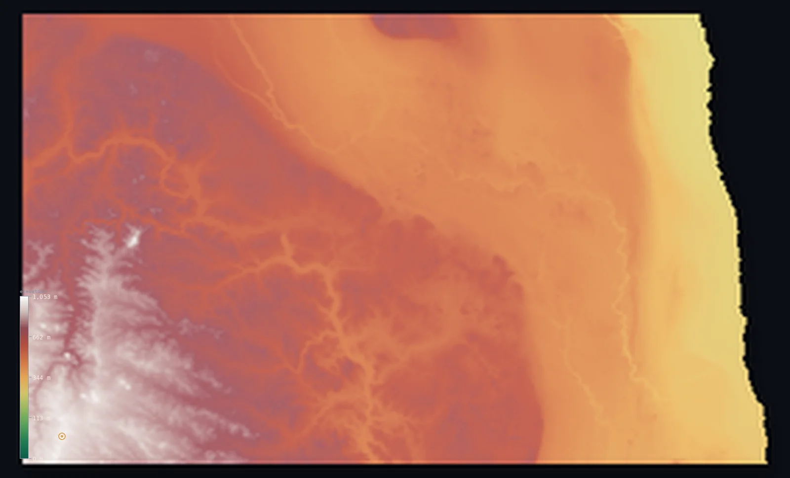
North Dakota’s highest point is White Butte at 3,507 ft (1,069 m); its lowest is Red River of the North at 751 ft (229 m); the mean elevation is 1,827 ft (557 m).
- Highest point📚
- 3,507 ft1,069 m
- White Butte.
- Lowest point📚
- 751 ft229 m
- Red River of the North.
- Mean elevation⚙
- 1,827 ft557 m
- Computed from the GLO-30 surface model.
- Median elevation⚙
- 1,841 ft561 m
- Half of North Dakota lies below this height.
- Elevation range📚
- 2,756 ft840 m
- From 229 m to White Butte's 1069 m.
- Above 1,000 m (3,281 ft)⚙
- <1%
- The state's higher ground.
- Official area📚
- 70,698 mi²183,108 km²
- North Dakota.
North Dakota at a glance
The Red River Valley, an old glacial lakebed, is one of the flattest large landscapes on Earth.
source ↗White Butte, the high point, is a pale clay peak rising from the Badlands.
source ↗The Little Missouri Badlands are a maze of eroded, colorfully banded clay and rock.
source ↗The geographic center of North America lies in North Dakota.
source ↗North Dakota tilts from the high western Badlands down to the flat Red River Valley in the east.
source ↗
Elevation profile of North Dakota
The largest share of land, 27%, falls in the 400–500 m band, and 59% of the territory lies above 500 m (1,640 ft).
- below 500 m (1,640 ft)41%
- 500–1,000 m59%
- 1,000–2,000 m<1%
Highest and lowest points
The highest point of North Dakota, White Butte, 1,069 m, a pale clay butte rising from the Badlands of the southwest - the high edge of the Great Plains before they roll east toward the dead-flat Red River Valley.
source ↗Highest peaks of North Dakota
| Peak | Elevation | Range | Note |
|---|---|---|---|
| White Butte↗ | 3,507 ft1,069 m | Missouri Plateau (Badlands) | Highest point of North Dakota, a clay butte. |
| Black Butte↗ | 3,379 ft1,030 m | Missouri Plateau | A high butte near White Butte in the southwest. |
| Sentinel Butte↗ | 3,281 ft1,000 m | Missouri Plateau | A prominent butte of the western Badlands. |
| Bullion Butte↗ | 3,199 ft975 m | Missouri Plateau | A large flat-topped butte of the Badlands. |
| Camels Hump Butte↗ | 2,953 ft900 m | Missouri Plateau | A high point of the western plateau. |
Terrain regions of North Dakota
The Red River Valley, an old glacial lakebed, is one of the flattest large landscapes on Earth. ↗
The western Badlands and buttes
↗Southwestern North Dakota rises onto the Missouri Plateau, the higher, drier western plains, cut by the colorful, eroded Badlands along the Little Missouri Rive
The Missouri Plateau and drift prairie
↗The centre of the state is rolling plains - the Missouri Coteau, a hilly belt of glacial hummocks and potholes, and the drift prairie, gently rolling farmland s
The Red River Valley
↗Eastern North Dakota drops into the Red River Valley, the bed of a vast vanished glacial lake - one of the flattest landscapes on Earth, a dead-level plain of e
The western Badlands and buttes
the southwestSouthwestern North Dakota rises onto the Missouri Plateau, the higher, drier western plains, cut by the colorful, eroded Badlands along the Little Missouri River. Here White Butte (1,069 m), a pale clay peak, is the state's highest point, amid a rugged landscape utterly unlike the flat east.
The Missouri Plateau and drift prairie
the centreThe centre of the state is rolling plains - the Missouri Coteau, a hilly belt of glacial hummocks and potholes, and the drift prairie, gently rolling farmland shaped by the glaciers. The Missouri River threads across it, dammed into the long Lake Sakakawea.
The Red River Valley
the eastEastern North Dakota drops into the Red River Valley, the bed of a vast vanished glacial lake - one of the flattest landscapes on Earth, a dead-level plain of extraordinarily fertile black soil sloping imperceptibly north, holding the state's lowest point at 229 m.
City elevations in North Dakota
| City | Population | Elevation |
|---|---|---|
| Fargo | 118,523 | 909 ft277 m |
| Bismarck | 75,092 | 1,696 ft517 m |
| Grand Forks | 57,011 | 843 ft257 m |
| Minot | 49,450 | 1,617 ft493 m |
| Williston | 26,977 | 1,877 ft572 m |
| Dickinson | 23,765 | 2,415 ft736 m |
| Jamestown | 15,422 | 1,411 ft430 m |
| Wahpeton | 7,899 | 968 ft295 m |
| Devils Lake | 7,351 | 1,457 ft444 m |
| Watford City | 6,708 | 2,129 ft649 m |
Elevation sampled at each city centre from the Copernicus GLO-30 model. Cities and population from GeoNames (CC-BY 4.0).
North Dakota in comparison
North Dakota's terrain rises 2,756 ft (840 m) from Red River of the North (751 ft (229 m)) to White Butte — about 9% of the height of Mount Everest, the world's highest point at 29,032 ft (8,849 m).
Frequently asked questions
What is the highest point in North Dakota?
- White Butte, 3,507 ft (1,069 m).
What is the average elevation of North Dakota?
- About 580 m according to the USGS; this page also reports the area-weighted mean computed from the Copernicus GLO-30 model, 1,827 ft (557 m).
What is the lowest point in North Dakota?
- Red River of the North, 751 ft (229 m).
The Red River Valley?
- The Red River Valley, an old glacial lakebed, is one of the flattest large landscapes on Earth.
Where is the highest ground in North Dakota?
- Southwestern North Dakota rises onto the Missouri Plateau, the higher, drier western plains, cut by the colorful, eroded Badlands along the Little Missouri River. Here White Butte (1,069 m), a pale cl
Is this a topographic, relief, contour, or elevation map of North Dakota?
- They describe the same thing - terrain height. This page renders North Dakota's actual elevation surface in interactive 3D (a relief or topographic view) and reports the statistics computed from it; a contour map shows the same data as lines of equal height.
About this map
The terrain is rendered from the Copernicus GLO-30 digital elevation model (ESA), masked to the US-ND boundary from geoBoundaries (gbOpen). Elevation statistics are computed directly from the model; peak names and researched facts are sourced and cited. See the methodology for the full pipeline.
Our area-weighted mean, computed from the Copernicus GLO-30 model, is 1,827 ft (557 m); the figure commonly cited elsewhere is 1,903 ft (580 m) (U.S. Geological Survey). North Dakota's mean elevation is about 580 m; the page reports the area-weighted figure computed from the Copernicus GLO-30 model.
Surveyed national figures: official area · high point.
Rendered from Copernicus GLO-30 (ESA, 2021 release), boundaries from geoBoundaries. Generated 2026-07-14.