Minnesota Elevation Map
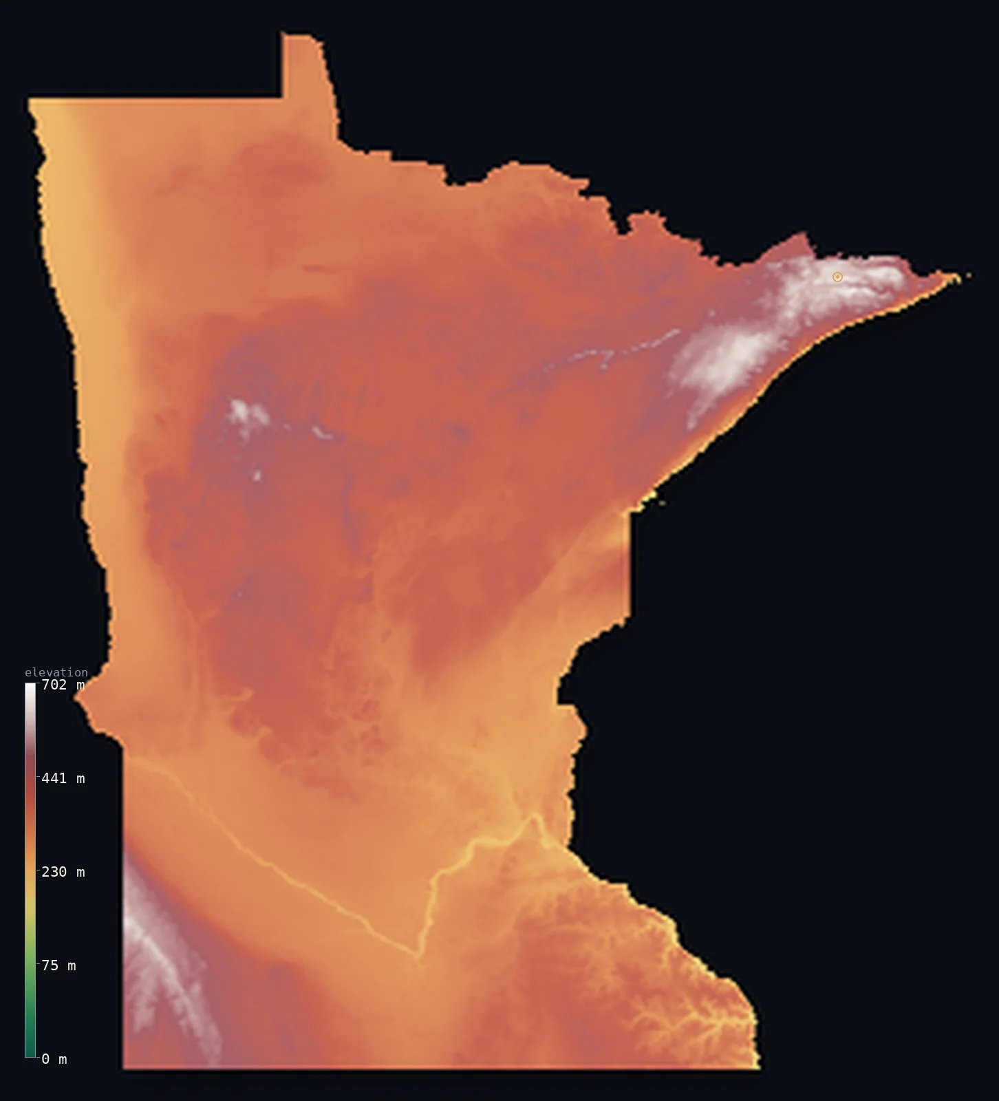
Minnesota’s highest point is Eagle Mountain at 2,300 ft (701 m); its lowest is Lake Superior at 600 ft (183 m); the mean elevation is 1,220 ft (372 m).
- Highest point📚
- 2,300 ft701 m
- Eagle Mountain.
- Lowest point📚
- 600 ft183 m
- Lake Superior.
- Mean elevation⚙
- 1,220 ft372 m
- Computed from the GLO-30 surface model.
- Median elevation⚙
- 1,211 ft369 m
- Half of Minnesota lies below this height.
- Elevation range📚
- 1,699 ft518 m
- From 183 m to Eagle Mountain's 701 m.
- Official area📚
- 86,936 mi²225,163 km²
- Minnesota.
Minnesota at a glance
Minnesota's highest and lowest points sit only about 25 km apart in the Arrowhead region.
source ↗The Mississippi River begins as a small stream flowing out of Lake Itasca in northern Minnesota.
source ↗The Driftless Area of the southeast was never glaciated, keeping deep valleys the rest of the state lacks.
source ↗Minnesota's nickname counts 10,000 lakes, but it actually has nearly 12,000.
source ↗The state's lowest point is the surface of Lake Superior, not sea level - Minnesota touches no ocean.
source ↗
Elevation profile of Minnesota
The largest share of land, 28%, falls in the 350–400 m band, and 95% of the territory lies below 500 m (1,640 ft).
- below 500 m (1,640 ft)95%
- 500–1,000 m5%
Highest and lowest points
The highest point of Minnesota, Eagle Mountain, 701 m, in the wild Arrowhead country near Lake Superior - remarkably, it sits only about 25 km from the state's lowest point on the lake shore.
source ↗Highest peaks of Minnesota
| Peak | Elevation | Range | Note |
|---|---|---|---|
| Eagle Mountain↗ | 2,300 ft701 m | Misquah Hills | Highest point of Minnesota, near Lake Superior. |
| Moose Mountain↗ | 2,274 ft693 m | Sawtooth Mountains | A high ridge of the North Shore highlands. |
| Peak 2266↗ | 2,264 ft690 m | Misquah Hills | An unnamed high summit near Eagle Mountain. |
| Lima Mountain↗ | 2,175 ft663 m | Misquah Hills | A high point of the Arrowhead region. |
| Carlton Peak↗ | 919 ft280 m | Sawtooth Mountains | A well-known knob above the Lake Superior shore. |
Terrain regions of Minnesota
Minnesota's highest and lowest points sit only about 25 km apart in the Arrowhead region. ↗
The Arrowhead and North Shore
↗Northeastern Minnesota is the rugged Arrowhead - ancient rock, boreal forest, and thousands of lakes along the North Shore of Lake Superior. Here the Misquah Hi
The lake country and moraines
↗Most of Minnesota is glacier-shaped lake country - the land of 10,000 lakes - a rolling surface of moraines, drumlins and bogs left by the Ice Age, dotted with
The prairies and river valleys
↗Southern and western Minnesota flattens into tallgrass prairie and farmland, the eastern edge of the Great Plains, cut by the Minnesota and Mississippi river va
The Arrowhead and North Shore
the northeastNortheastern Minnesota is the rugged Arrowhead - ancient rock, boreal forest, and thousands of lakes along the North Shore of Lake Superior. Here the Misquah Hills lift Eagle Mountain (701 m), the state high point, just a short distance inland from the lake, the lowest point - the greatest relief in an otherwise gentle state.
The lake country and moraines
the centre and northMost of Minnesota is glacier-shaped lake country - the land of 10,000 lakes - a rolling surface of moraines, drumlins and bogs left by the Ice Age, dotted with the lakes and wetlands that feed the headwaters of the Mississippi River at Lake Itasca.
The prairies and river valleys
the south and westSouthern and western Minnesota flattens into tallgrass prairie and farmland, the eastern edge of the Great Plains, cut by the Minnesota and Mississippi river valleys. In the far southeast the Driftless Area, missed by the last glaciers, keeps a rougher, bluff-cut landscape along the Mississippi.
City elevations in Minnesota
| City | Population | Elevation |
|---|---|---|
| Minneapolis | 410,939 | 843 ft257 m |
| Fargo | 118,523 | 909 ft277 m |
| Rochester | 112,225 | 1,030 ft314 m |
| Duluth | 86,110 | 715 ft218 m |
| Saint Cloud | 65,842 | 1,043 ft318 m |
| Grand Forks | 57,011 | 843 ft257 m |
| Mankato | 41,044 | 814 ft248 m |
| Winona | 27,094 | 669 ft204 m |
| Owatonna | 25,725 | 1,158 ft353 m |
| Willmar | 19,638 | 1,142 ft348 m |
Elevation sampled at each city centre from the Copernicus GLO-30 model. Cities and population from GeoNames (CC-BY 4.0).
Minnesota in comparison
Minnesota's terrain rises 1,699 ft (518 m) from Lake Superior (600 ft (183 m)) to Eagle Mountain — about 6% of the height of Mount Everest, the world's highest point at 29,032 ft (8,849 m).
Frequently asked questions
What is the highest point in Minnesota?
- Eagle Mountain, 2,300 ft (701 m).
What is the average elevation of Minnesota?
- About 370 m according to the USGS; this page also reports the area-weighted mean computed from the Copernicus GLO-30 model, 1,220 ft (372 m).
What is the lowest point in Minnesota?
- Lake Superior, 600 ft (183 m).
Minnesota's highest and lowest points sit only about 25 km apart in the Arrowhead region?
- Minnesota's highest and lowest points sit only about 25 km apart in the Arrowhead region.
Where is the highest ground in Minnesota?
- Northeastern Minnesota is the rugged Arrowhead - ancient rock, boreal forest, and thousands of lakes along the North Shore of Lake Superior. Here the Misquah Hills lift Eagle Mountain (701 m), the sta
Is this a topographic, relief, contour, or elevation map of Minnesota?
- They describe the same thing - terrain height. This page renders Minnesota's actual elevation surface in interactive 3D (a relief or topographic view) and reports the statistics computed from it; a contour map shows the same data as lines of equal height.
About this map
The terrain is rendered from the Copernicus GLO-30 digital elevation model (ESA), masked to the US-MN boundary from geoBoundaries (gbOpen). Elevation statistics are computed directly from the model; peak names and researched facts are sourced and cited. See the methodology for the full pipeline.
Our area-weighted mean, computed from the Copernicus GLO-30 model, is 1,220 ft (372 m); the figure commonly cited elsewhere is 1,214 ft (370 m) (U.S. Geological Survey). Minnesota's mean elevation is about 370 m; the page reports the area-weighted figure computed from the Copernicus GLO-30 model.
Surveyed national figures: official area · high point.
Rendered from Copernicus GLO-30 (ESA, 2021 release), boundaries from geoBoundaries. Generated 2026-07-14.