Iowa Elevation Map
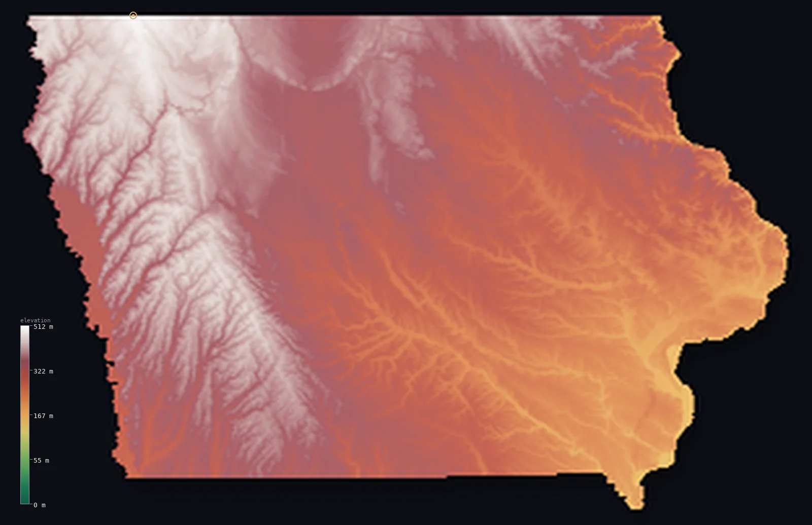
Iowa’s highest point is Hawkeye Point at 1,670 ft (509 m); its lowest is Mississippi River at 479 ft (146 m); the mean elevation is 1,066 ft (325 m).
- Highest point📚
- 1,670 ft509 m
- Hawkeye Point.
- Lowest point📚
- 479 ft146 m
- Mississippi River.
- Mean elevation⚙
- 1,066 ft325 m
- Computed from the GLO-30 surface model.
- Median elevation⚙
- 1,086 ft331 m
- Half of Iowa lies below this height.
- Elevation range📚
- 1,191 ft363 m
- From 146 m to Hawkeye Point's 509 m.
- Official area📚
- 56,273 mi²145,746 km²
- Iowa.
Iowa at a glance
Iowa's Loess Hills, built from wind-blown glacial silt, are so distinctive they are matched only in China.
source ↗Hawkeye Point, the high point, is a gentle rise in a working farm field marked by a sign.
source ↗Northeastern Iowa's Driftless Area escaped the glaciers, keeping deep valleys and bluffs.
source ↗Iowa is bounded by two great rivers - the Missouri on the west and the Mississippi on the east.
source ↗Some of the deepest, most fertile topsoil on Earth lies beneath Iowa's rolling farmland.
source ↗
Elevation profile of Iowa
The largest share of land, 15%, falls in the 350–375 m band, and >99% of the territory lies below 500 m (1,640 ft).
- below 500 m (1,640 ft)>99%
- 500–1,000 m<1%
Highest and lowest points
The highest point of Iowa, Hawkeye Point, 509 m, a gentle rise in a farm field in the state's far northwest corner - the high shoulder of a landscape almost entirely given over to gently rolling farmland.
source ↗Highest peaks of Iowa
| Peak | Elevation | Range | Note |
|---|---|---|---|
| Hawkeye Point↗ | 1,670 ft509 m | Northwest till plains | Highest point of Iowa, a rise in a farm field. |
| Ocheyedan Mound↗ | 1,608 ft490 m | Northwest Iowa | A glacial hill once thought the state's highest point. |
| Pilot Knob↗ | 1,542 ft470 m | North-central Iowa | A prominent glacial hill and state park. |
| Loess Hills highpoint↗ | 1,411 ft430 m | Loess Hills | High points of the wind-built Loess Hills in the west. |
| Driftless bluffs↗ | 1,247 ft380 m | Driftless Area | High bluffs along the Mississippi in the northeast. |
Terrain regions of Iowa
Iowa's Loess Hills, built from wind-blown glacial silt, are so distinctive they are matched only in China. ↗
The northwest and till plains
↗Most of Iowa is gently rolling till plain - deep, rich farmland left by the glaciers, the heart of the Corn Belt. The land rises almost imperceptibly toward the
The Loess Hills of the west
↗Along the western edge above the Missouri River rise the Loess Hills, a narrow band of steep, sharp hills built entirely from wind-blown glacial silt piled up a
The Driftless Area of the northeast
↗Northeastern Iowa is part of the Driftless Area, missed by the last glaciers, where the Mississippi and its tributaries have cut deep valleys and high limestone
The northwest and till plains
most of the stateMost of Iowa is gently rolling till plain - deep, rich farmland left by the glaciers, the heart of the Corn Belt. The land rises almost imperceptibly toward the northwest corner, reaching Hawkeye Point (509 m), the state high point, in a farm field near Minnesota.
The Loess Hills of the west
the far westAlong the western edge above the Missouri River rise the Loess Hills, a narrow band of steep, sharp hills built entirely from wind-blown glacial silt piled up after the Ice Age - a landform this dramatic found in only one other place on Earth, in China.
The Driftless Area of the northeast
the northeastNortheastern Iowa is part of the Driftless Area, missed by the last glaciers, where the Mississippi and its tributaries have cut deep valleys and high limestone bluffs - the most rugged and scenic corner of an otherwise gentle state, holding the state's lowest point where the Mississippi leaves at 146 m.
City elevations in Iowa
| City | Population | Elevation |
|---|---|---|
| Des Moines | 214,133 | 876 ft267 m |
| Cedar Rapids | 130,405 | 810 ft247 m |
| Davenport | 102,582 | 597 ft182 m |
| Sioux City | 82,821 | 1,204 ft367 m |
| Waterloo | 68,460 | 853 ft260 m |
| Ames | 65,060 | 948 ft289 m |
| Council Bluffs | 62,597 | 988 ft301 m |
| Dubuque | 58,799 | 627 ft191 m |
| Marshalltown | 27,620 | 942 ft287 m |
| Mason City | 27,366 | 1,138 ft347 m |
Elevation sampled at each city centre from the Copernicus GLO-30 model. Cities and population from GeoNames (CC-BY 4.0).
Iowa in comparison
Iowa's terrain rises 1,191 ft (363 m) from Mississippi River (479 ft (146 m)) to Hawkeye Point — about 4% of the height of Mount Everest, the world's highest point at 29,032 ft (8,849 m).
Frequently asked questions
What is the highest point in Iowa?
- Hawkeye Point, 1,670 ft (509 m).
What is the average elevation of Iowa?
- About 340 m according to the USGS; this page also reports the area-weighted mean computed from the Copernicus GLO-30 model, 1,066 ft (325 m).
What is the lowest point in Iowa?
- Mississippi River, 479 ft (146 m).
Iowa's Loess Hills?
- Iowa's Loess Hills, built from wind-blown glacial silt, are so distinctive they are matched only in China.
Where is the highest ground in Iowa?
- Most of Iowa is gently rolling till plain - deep, rich farmland left by the glaciers, the heart of the Corn Belt. The land rises almost imperceptibly toward the northwest corner, reaching Hawkeye Poin
Is this a topographic, relief, contour, or elevation map of Iowa?
- They describe the same thing - terrain height. This page renders Iowa's actual elevation surface in interactive 3D (a relief or topographic view) and reports the statistics computed from it; a contour map shows the same data as lines of equal height.
About this map
The terrain is rendered from the Copernicus GLO-30 digital elevation model (ESA), masked to the US-IA boundary from geoBoundaries (gbOpen). Elevation statistics are computed directly from the model; peak names and researched facts are sourced and cited. See the methodology for the full pipeline.
Our area-weighted mean, computed from the Copernicus GLO-30 model, is 1,066 ft (325 m); the figure commonly cited elsewhere is 1,115 ft (340 m) (U.S. Geological Survey). Iowa's mean elevation is about 340 m; the page reports the area-weighted figure computed from the Copernicus GLO-30 model.
Surveyed national figures: official area · high point.
Rendered from Copernicus GLO-30 (ESA, 2021 release), boundaries from geoBoundaries. Generated 2026-07-14.