South Dakota Elevation Map
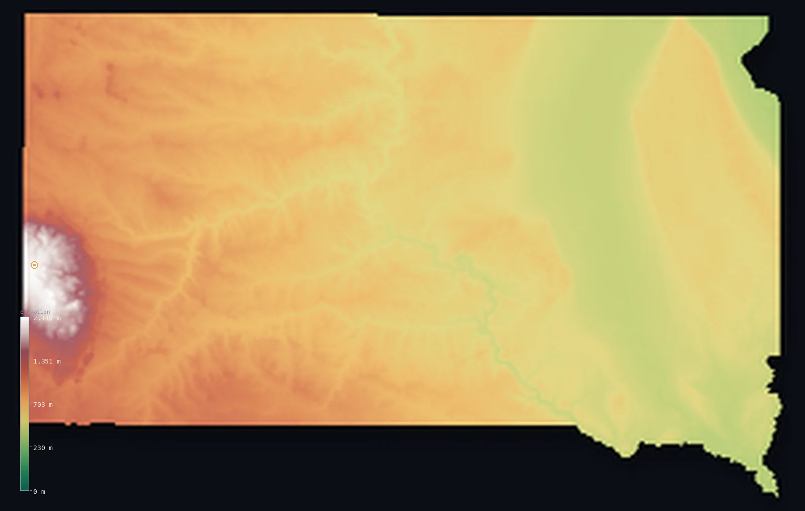
South Dakota’s highest point is Black Elk Peak at 7,241 ft (2,207 m); its lowest is Big Stone Lake at 968 ft (295 m); the mean elevation is 2,185 ft (666 m).
- Highest point📚
- 7,241 ft2,207 m
- Black Elk Peak.
- Lowest point📚
- 968 ft295 m
- Big Stone Lake.
- Mean elevation⚙
- 2,185 ft666 m
- Computed from the GLO-30 surface model.
- Median elevation⚙
- 1,932 ft589 m
- Half of South Dakota lies below this height.
- Elevation range📚
- 6,273 ft1,912 m
- From 295 m to Black Elk Peak's 2207 m.
- Above 1,000 m (3,281 ft)⚙
- 8%
- The state's higher ground.
- Official area📚
- 77,116 mi²199,729 km²
- South Dakota.
South Dakota at a glance
Black Elk Peak is the highest point in the United States east of the Rocky Mountains.
source ↗The Black Hills are a small, ancient mountain range rising like a forested island from the Great Plains.
source ↗The South Dakota Badlands are a striking maze of eroded, colorfully banded rock.
source ↗Black Elk Peak is a sacred site to the Lakota people.
source ↗The Missouri River splits South Dakota into a higher, drier 'West River' and a gentler 'East River'.
source ↗
Elevation profile of South Dakota
The largest share of land, 44%, falls in the 400–600 m band, and 73% of the territory lies above 500 m (1,640 ft).
- below 500 m (1,640 ft)27%
- 500–1,000 m65%
- 1,000–2,000 m8%
- above 2,000 m (6,562 ft)<1%
Highest and lowest points
The highest point of South Dakota, Black Elk Peak, 2,207 m, in the Black Hills - the highest summit in the United States east of the Rockies, a granite peak sacred to the Lakota and rising from an island of forest in the plains.
source ↗Highest peaks of South Dakota
| Peak | Elevation | Range | Note |
|---|---|---|---|
| Black Elk Peak↗ | 7,241 ft2,207 m | Black Hills | Highest point of South Dakota, highest east of the Rockies. |
| Bear Mountain↗ | 7,096 ft2,163 m | Black Hills | A high summit of the western Black Hills. |
| Terry Peak↗ | 7,047 ft2,148 m | Black Hills | A high peak of the northern Black Hills. |
| Crooks Tower↗ | 6,975 ft2,126 m | Black Hills | One of the highest points of the Black Hills. |
| Little Devils Tower↗ | 6,562 ft2,000 m | Black Hills | A granite spire near Black Elk Peak. |
Terrain regions of South Dakota
Black Elk Peak is the highest point in the United States east of the Rocky Mountains. ↗
The Black Hills
↗The southwestern corner of South Dakota holds the Black Hills, a small, ancient, forested mountain range rising like an island from the plains. Its Black Elk Pe
The western plains and Badlands
↗West of the Missouri River lie the high, dry western plains - rolling grassland and, most strikingly, the Badlands, a surreal maze of eroded, banded buttes and
The eastern prairies and lakes
↗East of the Missouri, the land is lower, gentler glaciated prairie - rolling farmland, glacial lakes and the Coteau des Prairies, sloping toward the Minnesota b
The Black Hills
the southwestThe southwestern corner of South Dakota holds the Black Hills, a small, ancient, forested mountain range rising like an island from the plains. Its Black Elk Peak (2,207 m) is the highest point in the United States east of the Rocky Mountains, and the Hills hold granite spires, deep canyons and the carved faces of Mount Rushmore.
The western plains and Badlands
the westWest of the Missouri River lie the high, dry western plains - rolling grassland and, most strikingly, the Badlands, a surreal maze of eroded, banded buttes and pinnacles carved into the plateau. This is ranch country, higher and drier than the east.
The eastern prairies and lakes
the eastEast of the Missouri, the land is lower, gentler glaciated prairie - rolling farmland, glacial lakes and the Coteau des Prairies, sloping toward the Minnesota border and the state's lowest point on Big Stone Lake at 295 m.
City elevations in South Dakota
| City | Population | Elevation |
|---|---|---|
| Sioux Falls | 171,544 | 1,444 ft440 m |
| Rapid City | 73,569 | 3,248 ft990 m |
| Aberdeen | 28,102 | 1,306 ft398 m |
| Brookings | 23,657 | 1,621 ft494 m |
| Watertown | 22,073 | 1,739 ft530 m |
| Mitchell | 15,669 | 1,309 ft399 m |
| Yankton | 14,557 | 1,214 ft370 m |
| Pierre | 14,091 | 1,486 ft453 m |
| Huron | 13,313 | 1,283 ft391 m |
| Spearfish | 11,283 | 3,645 ft1,111 m |
Elevation sampled at each city centre from the Copernicus GLO-30 model. Cities and population from GeoNames (CC-BY 4.0).
South Dakota in comparison
South Dakota's terrain rises 6,273 ft (1,912 m) from Big Stone Lake (968 ft (295 m)) to Black Elk Peak — about 22% of the height of Mount Everest, the world's highest point at 29,032 ft (8,849 m).
Frequently asked questions
What is the highest point in South Dakota?
- Black Elk Peak, 7,241 ft (2,207 m).
What is the average elevation of South Dakota?
- About 670 m according to the USGS; this page also reports the area-weighted mean computed from the Copernicus GLO-30 model, 2,185 ft (666 m).
What is the lowest point in South Dakota?
- Big Stone Lake, 968 ft (295 m).
Black Elk Peak is the highest point in the United States east of the Rocky Mountains?
- Black Elk Peak is the highest point in the United States east of the Rocky Mountains.
Where is the highest ground in South Dakota?
- The southwestern corner of South Dakota holds the Black Hills, a small, ancient, forested mountain range rising like an island from the plains. Its Black Elk Peak (2,207 m) is the highest point in the
Is this a topographic, relief, contour, or elevation map of South Dakota?
- They describe the same thing - terrain height. This page renders South Dakota's actual elevation surface in interactive 3D (a relief or topographic view) and reports the statistics computed from it; a contour map shows the same data as lines of equal height.
About this map
The terrain is rendered from the Copernicus GLO-30 digital elevation model (ESA), masked to the US-SD boundary from geoBoundaries (gbOpen). Elevation statistics are computed directly from the model; peak names and researched facts are sourced and cited. See the methodology for the full pipeline.
Our area-weighted mean, computed from the Copernicus GLO-30 model, is 2,185 ft (666 m); the figure commonly cited elsewhere is 2,198 ft (670 m) (U.S. Geological Survey). South Dakota's mean elevation is about 670 m; the page reports the area-weighted figure computed from the Copernicus GLO-30 model.
Surveyed national figures: official area · high point.
Rendered from Copernicus GLO-30 (ESA, 2021 release), boundaries from geoBoundaries. Generated 2026-07-14.