Wyoming Elevation Map
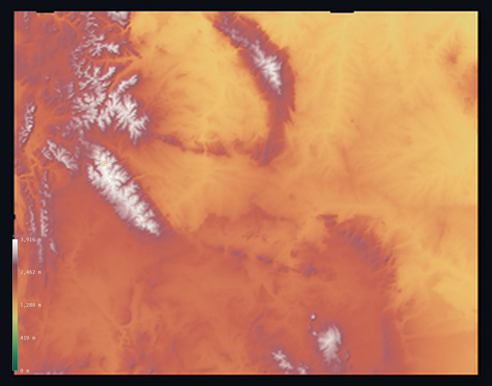
Wyoming’s highest point is Gannett Peak at 13,809 ft (4,209 m); its lowest is Belle Fourche River at 3,100 ft (945 m); the mean elevation is 6,398 ft (1,950 m).
- Highest point📚
- 13,809 ft4,209 m
- Gannett Peak.
- Lowest point📚
- 3,100 ft945 m
- Belle Fourche River.
- Mean elevation⚙
- 6,398 ft1,950 m
- Computed from the GLO-30 surface model.
- Median elevation⚙
- 6,549 ft1,996 m
- Half of Wyoming lies below this height.
- Elevation range📚
- 10,709 ft3,264 m
- From 945 m to Gannett Peak's 4209 m.
- Above 1,000 m (3,281 ft)⚙
- >99%
- The state's main highlands.
- Above 2,000 m (6,562 ft)⚙
- 50%
- The highest ranges.
- Official area📚
- 97,813 mi²253,335 km²
- Wyoming.
Wyoming at a glance
Wyoming's mean elevation of about 2,040 m makes it the second-highest state after Colorado.
source ↗The Wind River Range holds the largest glaciers in the American Rocky Mountains.
source ↗Gannett Peak is one of the most remote and difficult state high points to reach in the country.
source ↗Yellowstone sits atop one of the largest active volcanic systems on Earth.
source ↗Even Wyoming's lowest point, at 945 m, is higher than the highest point of eighteen other states.
source ↗
Elevation profile of Wyoming
The largest share of land, 21%, falls in the 2,000–2,200 m band, and 100% of the territory lies above 500 m (1,640 ft).
- 500–1,000 m<1%
- 1,000–2,000 m50%
- above 2,000 m (6,562 ft)50%
Highest and lowest points
The highest point of Wyoming, Gannett Peak, 4,209 m, deep in the Wind River Range - one of the most remote and least-climbed state high points, guarded by the largest glaciers in the American Rockies.
source ↗Highest peaks of Wyoming
| Peak | Elevation | Range | Note |
|---|---|---|---|
| Gannett Peak↗ | 13,809 ft4,209 m | Wind River Range | Highest point of Wyoming, remote and glaciated. |
| Grand Teton↗ | 13,776 ft4,199 m | Teton Range | The dramatic signature peak of the Teton Range. |
| Fremont Peak↗ | 13,750 ft4,191 m | Wind River Range | A high Wind River summit near Gannett. |
| Cloud Peak↗ | 13,166 ft4,013 m | Bighorn Mountains | The highest peak of the Bighorn Mountains. |
| Francs Peak↗ | 12,805 ft3,903 m | Absaroka Range | The highest peak of the Wyoming Absarokas. |
Terrain regions of Wyoming
Wyoming's mean elevation of about 2,040 m makes it the second-highest state after Colorado. ↗
The western ranges and Tetons
↗Western Wyoming is high mountain country - the Wind River Range, holding Gannett Peak (4,209 m) and the largest glaciers in the American Rockies, and the abrupt
Yellowstone and the volcanic northwest
↗The northwestern corner holds Yellowstone, a high volcanic plateau sitting atop a supervolcano, ringed by mountains and famous for its geysers and hot springs.
The basins and high plains
↗Between and east of the ranges lie Wyoming's great basins - the Bighorn, Wind River and Great Divide basins, high desert bowls of sagebrush and badlands. Eastwa
The western ranges and Tetons
the westWestern Wyoming is high mountain country - the Wind River Range, holding Gannett Peak (4,209 m) and the largest glaciers in the American Rockies, and the abrupt, spectacular Teton Range rising straight from Jackson Hole. The Continental Divide threads through, and much of the northwest is the volcanic plateau of Yellowstone.
Yellowstone and the volcanic northwest
the northwestThe northwestern corner holds Yellowstone, a high volcanic plateau sitting atop a supervolcano, ringed by mountains and famous for its geysers and hot springs. This is some of the highest average ground in the state, above 2,400 m across vast forests and basins.
The basins and high plains
the centre and eastBetween and east of the ranges lie Wyoming's great basins - the Bighorn, Wind River and Great Divide basins, high desert bowls of sagebrush and badlands. Eastward the land opens into the high Great Plains, still around 1,500 m, dropping to the state's lowest point on the Belle Fourche River at 945 m - higher than the highest point of many states.
City elevations in Wyoming
| City | Population | Elevation |
|---|---|---|
| Cheyenne | 65,132 | 6,096 ft1,858 m |
| Casper | 60,285 | 5,108 ft1,557 m |
| Gillette | 32,649 | 4,560 ft1,390 m |
| Laramie | 32,158 | 7,169 ft2,185 m |
| Rock Springs | 23,962 | 6,404 ft1,952 m |
| Sheridan | 17,873 | 3,753 ft1,144 m |
| Evanston | 12,133 | 6,752 ft2,058 m |
| Riverton | 10,873 | 4,954 ft1,510 m |
| Jackson | 10,523 | 6,243 ft1,903 m |
| Cody | 9,792 | 4,997 ft1,523 m |
Elevation sampled at each city centre from the Copernicus GLO-30 model. Cities and population from GeoNames (CC-BY 4.0).
Wyoming in comparison
Wyoming's terrain rises 10,709 ft (3,264 m) from Belle Fourche River (3,100 ft (945 m)) to Gannett Peak — about 37% of the height of Mount Everest, the world's highest point at 29,032 ft (8,849 m).
Frequently asked questions
What is the highest point in Wyoming?
- Gannett Peak, 13,809 ft (4,209 m).
What is the average elevation of Wyoming?
- About 2040 m according to the USGS; this page also reports the area-weighted mean computed from the Copernicus GLO-30 model, 6,398 ft (1,950 m).
What is the lowest point in Wyoming?
- Belle Fourche River, 3,100 ft (945 m).
Wyoming's mean elevation of about 2,040 m makes it the second-highest state after Colorado?
- Wyoming's mean elevation of about 2,040 m makes it the second-highest state after Colorado.
Where is the highest ground in Wyoming?
- Western Wyoming is high mountain country - the Wind River Range, holding Gannett Peak (4,209 m) and the largest glaciers in the American Rockies, and the abrupt, spectacular Teton Range rising straigh
Is this a topographic, relief, contour, or elevation map of Wyoming?
- They describe the same thing - terrain height. This page renders Wyoming's actual elevation surface in interactive 3D (a relief or topographic view) and reports the statistics computed from it; a contour map shows the same data as lines of equal height.
About this map
The terrain is rendered from the Copernicus GLO-30 digital elevation model (ESA), masked to the US-WY boundary from geoBoundaries (gbOpen). Elevation statistics are computed directly from the model; peak names and researched facts are sourced and cited. See the methodology for the full pipeline.
Our area-weighted mean, computed from the Copernicus GLO-30 model, is 6,398 ft (1,950 m); the figure commonly cited elsewhere is 6,693 ft (2,040 m) (U.S. Geological Survey). Wyoming's mean elevation is about 2040 m; the page reports the area-weighted figure computed from the Copernicus GLO-30 model.
Surveyed national figures: official area · high point.
Rendered from Copernicus GLO-30 (ESA, 2021 release), boundaries from geoBoundaries. Generated 2026-07-14.