Utah Elevation Map
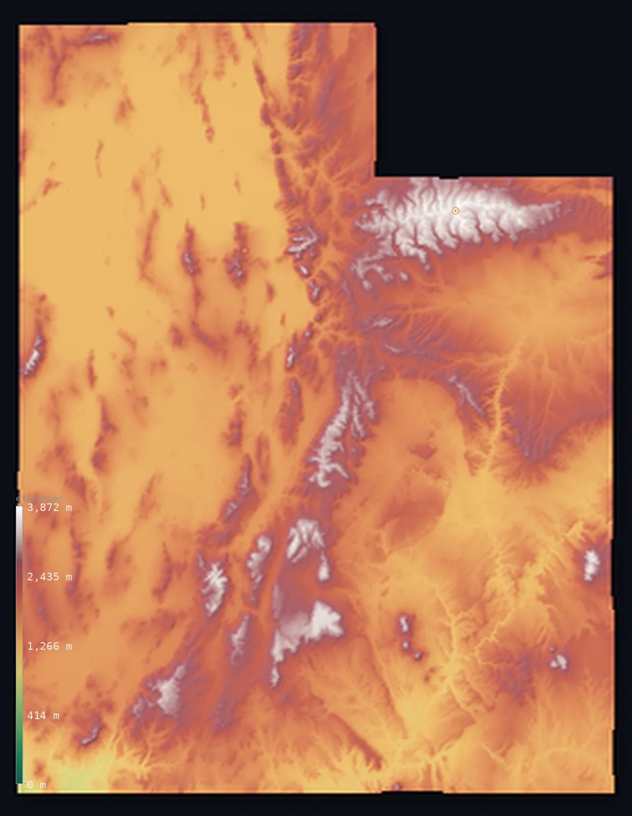
Utah’s highest point is Kings Peak at 13,517 ft (4,120 m); its lowest is Beaver Dam Wash at 2,001 ft (610 m); the mean elevation is 6,014 ft (1,833 m).
- Highest point📚
- 13,517 ft4,120 m
- Kings Peak.
- Lowest point📚
- 2,001 ft610 m
- Beaver Dam Wash.
- Mean elevation⚙
- 6,014 ft1,833 m
- Computed from the GLO-30 surface model.
- Median elevation⚙
- 5,676 ft1,730 m
- Half of Utah lies below this height.
- Elevation range📚
- 11,516 ft3,510 m
- From 610 m to Kings Peak's 4120 m.
- Above 1,000 m (3,281 ft)⚙
- >99%
- The state's main highlands.
- Above 2,000 m (6,562 ft)⚙
- 31%
- The highest ranges.
- Official area📚
- 84,897 mi²219,882 km²
- Utah.
Utah at a glance
The Uinta Mountains are one of the few major ranges in North America that run east-west rather than north-south.
source ↗The Bonneville Salt Flats are the dead-flat bed of a vast Ice Age lake.
source ↗Southern Utah's Colorado Plateau holds one of the greatest concentrations of canyons and arches on Earth.
source ↗The Great Salt Lake is the largest salt lake in the Western Hemisphere, a shrunken remnant of Ice Age Lake Bonneville.
source ↗Utah's five national parks protect one of the greatest concentrations of natural arches and slot canyons on Earth.
source ↗
Elevation profile of Utah
The largest share of land, 27%, falls in the 1,250–1,500 m band, and 100% of the territory lies above 500 m (1,640 ft).
- 500–1,000 m<1%
- 1,000–2,000 m69%
- above 2,000 m (6,562 ft)31%
Highest and lowest points
Highest peaks of Utah
| Peak | Elevation | Range | Note |
|---|---|---|---|
| Kings Peak↗ | 13,517 ft4,120 m | Uinta Mountains | Highest point of Utah, in the east-west Uintas. |
| South Kings Peak↗ | 13,510 ft4,118 m | Uinta Mountains | A twin summit just south of Kings Peak. |
| Gilbert Peak↗ | 13,471 ft4,106 m | Uinta Mountains | Among the highest summits of the Uintas. |
| Mount Peale↗ | 12,720 ft3,877 m | La Sal Mountains | The high point of the La Sal Mountains near Moab. |
| Ibapah Peak↗ | 12,087 ft3,684 m | Deep Creek Range | The high point of the western Utah desert ranges. |
Terrain regions of Utah
The Uinta Mountains are one of the few major ranges in North America that run east-west rather than north-south. ↗
The Wasatch and Uinta mountains
↗Northern Utah rises into the Wasatch Range, the abrupt western wall of the Rockies along which most of the state's people live, and the Uinta Mountains, a rare
The Great Basin and western desert
↗Western Utah lies in the Great Basin, a land of broad desert valleys and isolated mountain ranges where the rivers drain to no ocean. It holds the Great Salt La
The Colorado Plateau
↗Southern and eastern Utah is red-rock canyon country on the Colorado Plateau - a high tableland of mesas, arches, deep canyons and step-like cliffs carved by th
The Wasatch and Uinta mountains
the northNorthern Utah rises into the Wasatch Range, the abrupt western wall of the Rockies along which most of the state's people live, and the Uinta Mountains, a rare east-west range that carries Kings Peak (4,120 m), the state's summit. Snow-fed streams from these mountains feed the valleys below.
The Great Basin and western desert
the westWestern Utah lies in the Great Basin, a land of broad desert valleys and isolated mountain ranges where the rivers drain to no ocean. It holds the Great Salt Lake, the largest salt lake in the Western Hemisphere, and the dazzling white Bonneville Salt Flats, the bed of a vanished Ice Age lake.
The Colorado Plateau
the southeastSouthern and eastern Utah is red-rock canyon country on the Colorado Plateau - a high tableland of mesas, arches, deep canyons and step-like cliffs carved by the Colorado and Green rivers, holding the state's famous national parks.
City elevations in Utah
| City | Population | Elevation |
|---|---|---|
| Salt Lake City | 215,548 | 4,268 ft1,301 m |
| Provo | 115,162 | 4,560 ft1,390 m |
| Ogden | 85,444 | 4,308 ft1,313 m |
| Saint George | 72,897 | 2,700 ft823 m |
| Logan | 50,371 | 4,537 ft1,383 m |
| Cedar City | 30,184 | 5,853 ft1,784 m |
| Vernal | 11,200 | 5,335 ft1,626 m |
| Grantsville | 10,027 | 4,311 ft1,314 m |
| Price | 8,378 | 5,568 ft1,697 m |
| Richfield | 7,592 | 5,358 ft1,633 m |
Elevation sampled at each city centre from the Copernicus GLO-30 model. Cities and population from GeoNames (CC-BY 4.0).
Utah in comparison
Utah's terrain rises 11,516 ft (3,510 m) from Beaver Dam Wash (2,001 ft (610 m)) to Kings Peak — about 40% of the height of Mount Everest, the world's highest point at 29,032 ft (8,849 m).
Frequently asked questions
What is the highest point in Utah?
- Kings Peak, 13,517 ft (4,120 m).
What is the average elevation of Utah?
- About 1860 m according to the USGS; this page also reports the area-weighted mean computed from the Copernicus GLO-30 model, 6,014 ft (1,833 m).
What is the lowest point in Utah?
- Beaver Dam Wash, 2,001 ft (610 m).
The Uinta Mountains are one of the few major ranges in North America that run east-west rather than north-south?
- The Uinta Mountains are one of the few major ranges in North America that run east-west rather than north-south.
Where is the highest ground in Utah?
- Northern Utah rises into the Wasatch Range, the abrupt western wall of the Rockies along which most of the state's people live, and the Uinta Mountains, a rare east-west range that carries Kings Peak
Is this a topographic, relief, contour, or elevation map of Utah?
- They describe the same thing - terrain height. This page renders Utah's actual elevation surface in interactive 3D (a relief or topographic view) and reports the statistics computed from it; a contour map shows the same data as lines of equal height.
About this map
The terrain is rendered from the Copernicus GLO-30 digital elevation model (ESA), masked to the US-UT boundary from geoBoundaries (gbOpen). Elevation statistics are computed directly from the model; peak names and researched facts are sourced and cited. See the methodology for the full pipeline.
Our area-weighted mean, computed from the Copernicus GLO-30 model, is 6,014 ft (1,833 m); the figure commonly cited elsewhere is 6,102 ft (1,860 m) (U.S. Geological Survey). Utah's mean elevation is about 1860 m; the page reports the area-weighted figure computed from the Copernicus GLO-30 model.
Surveyed national figures: official area · high point.
Rendered from Copernicus GLO-30 (ESA, 2021 release), boundaries from geoBoundaries. Generated 2026-07-13.