Nevada Elevation Map
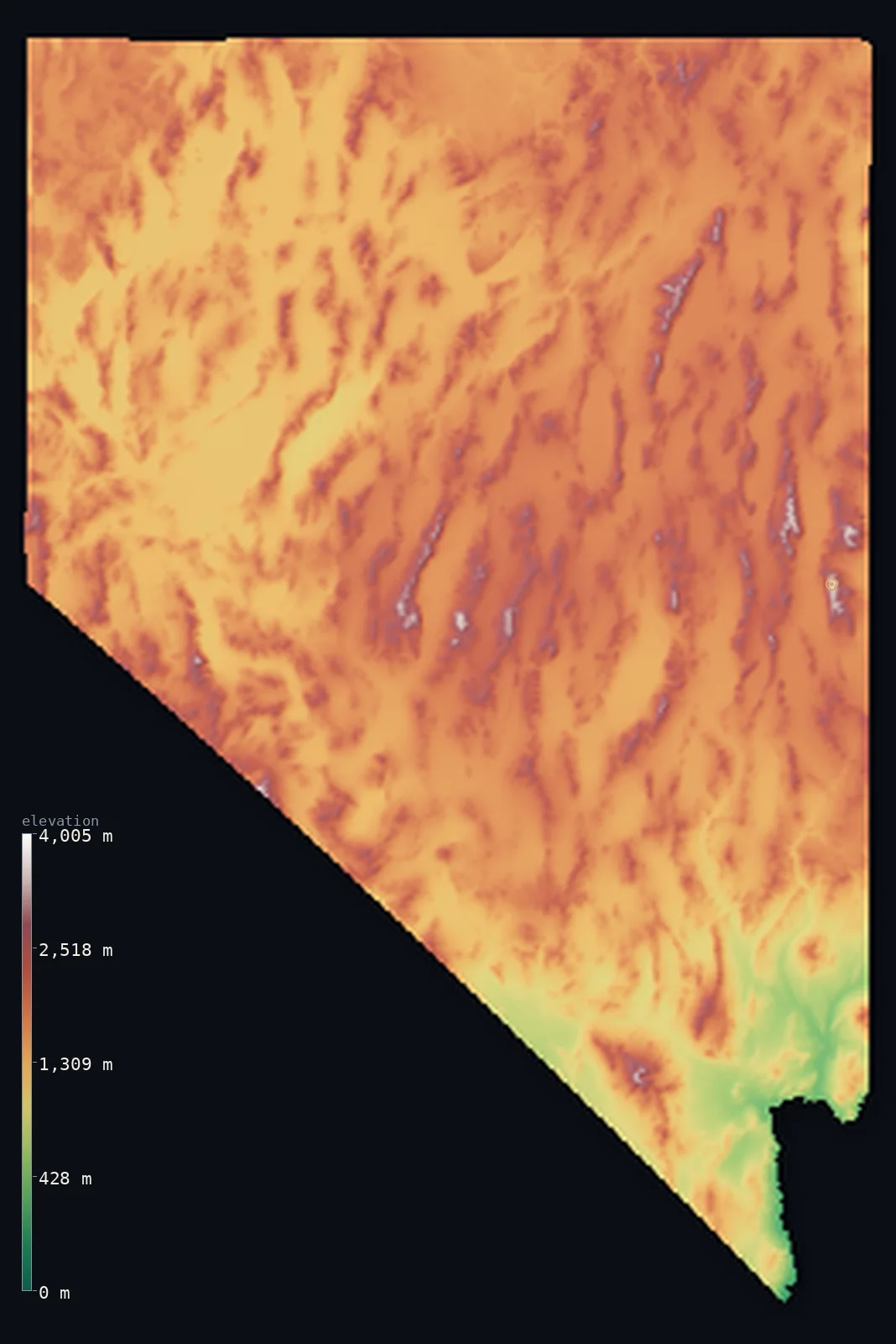
Nevada’s highest point is Boundary Peak at 13,140 ft (4,005 m); its lowest is Colorado River at 472 ft (144 m); the mean elevation is 5,528 ft (1,685 m).
- Highest point📚
- 13,140 ft4,005 m
- Boundary Peak.
- Lowest point📚
- 472 ft144 m
- Colorado River.
- Mean elevation⚙
- 5,528 ft1,685 m
- Computed from the GLO-30 surface model.
- Median elevation⚙
- 5,620 ft1,713 m
- Half of Nevada lies below this height.
- Elevation range📚
- 12,667 ft3,861 m
- From 144 m to Boundary Peak's 4005 m.
- Above 1,000 m (3,281 ft)⚙
- 94%
- The state's main highlands.
- Above 2,000 m (6,562 ft)⚙
- 20%
- The highest ranges.
- Official area📚
- 110,572 mi²286,380 km²
- Nevada.
Nevada at a glance
Nevada is the most mountainous state after Alaska, crossed by more than 150 named ranges.
source ↗Its highest point, Boundary Peak, is really a spur of California's White Mountains just over the state line.
source ↗Nevada is the driest state in the nation, most of it endorheic desert draining to no ocean.
source ↗Wheeler Peak, the highest summit wholly within Nevada, shelters some of the oldest living bristlecone pines on Earth.
source ↗Nevada's terrain is corrugated into more than 150 separate mountain ranges, nearly all running north to south.
source ↗
Elevation profile of Nevada
The largest share of land, 26%, falls in the 1,750–2,000 m band, and 99% of the territory lies above 500 m (1,640 ft).
- below 500 m (1,640 ft)1%
- 500–1,000 m5%
- 1,000–2,000 m74%
- above 2,000 m (6,562 ft)20%
Highest and lowest points
Highest peaks of Nevada
| Peak | Elevation | Range | Note |
|---|---|---|---|
| Boundary Peak↗ | 13,140 ft4,005 m | White Mountains | Highest point of Nevada, on the California line. |
| Wheeler Peak↗ | 13,064 ft3,982 m | Snake Range | The highest peak wholly within Nevada, in Great Basin National Park. |
| Mount Jefferson↗ | 11,949 ft3,642 m | Toquima Range | The high point of central Nevada's ranges. |
| North Schell Peak↗ | 11,883 ft3,622 m | Schell Creek Range | A high summit of eastern Nevada. |
| Arc Dome↗ | 11,772 ft3,588 m | Toiyabe Range | A high peak of the central Great Basin. |
Terrain regions of Nevada
Nevada is the most mountainous state after Alaska, crossed by more than 150 named ranges. ↗
The Great Basin ranges
↗Almost all of Nevada lies in the Great Basin, and the state is corrugated by dozens of long, narrow, parallel mountain ranges running north-south, separated by
The western Sierra front and Lake Tahoe
↗Western Nevada rises toward the Sierra Nevada along the California border, catching the edge of the high country around Lake Tahoe. Reno and Carson City sit in
The southern deserts
↗Southern Nevada drops into the hotter, lower Mojave Desert around Las Vegas, reaching the state's lowest point where the Colorado River leaves it at 144 m. This
The Great Basin ranges
most of the stateAlmost all of Nevada lies in the Great Basin, and the state is corrugated by dozens of long, narrow, parallel mountain ranges running north-south, separated by broad desert valleys - the classic 'basin and range' country. The rivers here drain inward to sinks and dry lakes, never reaching the sea. Boundary Peak (4,005 m) on the California line is the highest.
The western Sierra front and Lake Tahoe
the westWestern Nevada rises toward the Sierra Nevada along the California border, catching the edge of the high country around Lake Tahoe. Reno and Carson City sit in this transition, in the rain shadow where the Sierra wrings out the Pacific storms.
The southern deserts
the southSouthern Nevada drops into the hotter, lower Mojave Desert around Las Vegas, reaching the state's lowest point where the Colorado River leaves it at 144 m. This is a land of stark desert basins and the reservoirs of the dammed Colorado.
City elevations in Nevada
| City | Population | Elevation |
|---|---|---|
| Las Vegas | 641,903 | 2,001 ft610 m |
| Reno | 264,165 | 4,524 ft1,379 m |
| Bullhead City | 39,445 | 554 ft169 m |
| Pahrump | 36,441 | 2,697 ft822 m |
| Elko | 20,279 | 5,069 ft1,545 m |
| Mesquite | 17,496 | 1,608 ft490 m |
| Gardnerville Ranchos | 11,312 | 4,859 ft1,481 m |
| Fallon | 8,458 | 3,967 ft1,209 m |
| Winnemucca | 7,887 | 4,298 ft1,310 m |
| West Wendover | 4,294 | 4,455 ft1,358 m |
Elevation sampled at each city centre from the Copernicus GLO-30 model. Cities and population from GeoNames (CC-BY 4.0).
Nevada in comparison
Nevada's terrain rises 12,667 ft (3,861 m) from Colorado River (472 ft (144 m)) to Boundary Peak — about 44% of the height of Mount Everest, the world's highest point at 29,032 ft (8,849 m).
Frequently asked questions
What is the highest point in Nevada?
- Boundary Peak, 13,140 ft (4,005 m).
What is the average elevation of Nevada?
- About 1680 m according to the USGS; this page also reports the area-weighted mean computed from the Copernicus GLO-30 model, 5,528 ft (1,685 m).
What is the lowest point in Nevada?
- Colorado River, 472 ft (144 m).
Nevada is the most mountainous state after Alaska, crossed by more than 150 named ranges?
- Nevada is the most mountainous state after Alaska, crossed by more than 150 named ranges.
Where is the highest ground in Nevada?
- Almost all of Nevada lies in the Great Basin, and the state is corrugated by dozens of long, narrow, parallel mountain ranges running north-south, separated by broad desert valleys - the classic 'basi
Is this a topographic, relief, contour, or elevation map of Nevada?
- They describe the same thing - terrain height. This page renders Nevada's actual elevation surface in interactive 3D (a relief or topographic view) and reports the statistics computed from it; a contour map shows the same data as lines of equal height.
About this map
The terrain is rendered from the Copernicus GLO-30 digital elevation model (ESA), masked to the US-NV boundary from geoBoundaries (gbOpen). Elevation statistics are computed directly from the model; peak names and researched facts are sourced and cited. See the methodology for the full pipeline.
Our area-weighted mean, computed from the Copernicus GLO-30 model, is 5,528 ft (1,685 m); the figure commonly cited elsewhere is 5,512 ft (1,680 m) (U.S. Geological Survey). Nevada's mean elevation is about 1680 m; the page reports the area-weighted figure computed from the Copernicus GLO-30 model.
Surveyed national figures: official area · high point.
Rendered from Copernicus GLO-30 (ESA, 2021 release), boundaries from geoBoundaries. Generated 2026-07-13.