Colorado Elevation Map
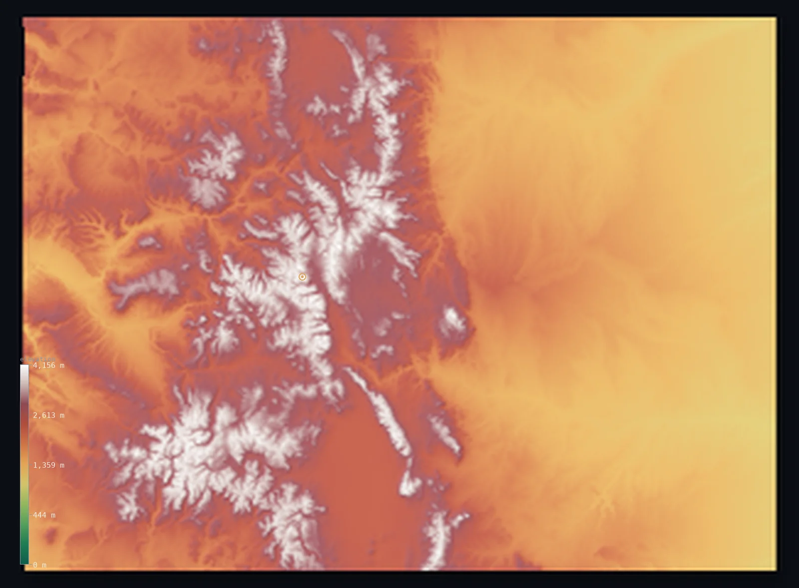
Colorado’s highest point is Mount Elbert at 14,439 ft (4,401 m); its lowest is Arikaree River at 3,317 ft (1,011 m); the mean elevation is 6,867 ft (2,093 m).
- Highest point📚
- 14,439 ft4,401 m
- Mount Elbert, in the Sawatch Range of the central Rockies.
- Lowest point📚
- 3,317 ft1,011 m
- The Arikaree River where it leaves the state, about 1,011 m.
- Mean elevation⚙
- 6,867 ft2,093 m
- Computed from the GLO-30 surface model across the state.
- Median elevation⚙
- 6,542 ft1,994 m
- Half of Colorado lies below this height.
- Elevation range📚
- 11,122 ft3,390 m
- From 1,011 m on the eastern plains to Elbert's 4,401 m.
- Above 1,000 m (3,281 ft)⚙
- 100%
- The Rocky Mountains of the central and western state.
- Above 2,000 m (6,562 ft)⚙
- 50%
- The high Sawatch, Sangre de Cristo and Elk ranges.
- Official area📚
- 104,093 mi²269,601 km²
- The highest state in the nation - high plains rising to the Rockies.
Colorado at a glance
Colorado has the highest mean elevation of any US state, about 2,070 m.
source ↗Its lowest point, on the Arikaree River, is still higher than the highest points of 18 other states.
source ↗The state has 58 peaks above 14,000 feet - the famous 'fourteeners'.
source ↗Mount Elbert, the highest peak in the Rockies, is a walk-up requiring no technical climbing.
source ↗Denver, the capital, sits almost exactly a mile above sea level.
source ↗
Elevation profile of Colorado
The largest share of land, 18%, falls in the 1,250–1,500 m band, and 100% of the territory lies above 500 m (1,640 ft).
- 1,000–2,000 m50%
- above 2,000 m (6,562 ft)50%
Highest and lowest points
The highest point of Colorado, Mount Elbert, 4,401 m, in the Sawatch Range of the Rocky Mountains - the highest peak of the entire Rocky Mountain system and the highest point in the Mississippi River basin. It is one of Colorado's 58 'fourteeners', peaks above 14,000 feet, yet is a non-technical walk-up.
source ↗Highest peaks of Colorado
| Peak | Elevation | Range | Note |
|---|---|---|---|
| Mount Elbert↗ | 14,439 ft4,401 m | Sawatch Range (Rockies) | Highest point of Colorado and of the Rocky Mountains. |
| Mount Massive↗ | 14,429 ft4,398 m | Sawatch Range | The second-highest peak in Colorado, just 3 m below Elbert. |
| Mount Harvard↗ | 14,419 ft4,395 m | Sawatch Range (Collegiate Peaks) | The third-highest peak in the state, in the Collegiate Peaks. |
| Blanca Peak↗ | 14,350 ft4,374 m | Sangre de Cristo Mountains | The highest peak of the Sangre de Cristo Range in the south. |
| Uncompahgre Peak↗ | 14,321 ft4,365 m | San Juan Mountains | The highest summit of the rugged San Juan Mountains in the southwest. |
Terrain regions of Colorado
Colorado has the highest mean elevation of any US state, about 2,070 m. ↗
The eastern plains
↗The high, flat western edge of the Great Plains covering the eastern two-fifths of the state, sloping up gently toward the mountains.
The Rocky Mountains
↗The central belt of high ranges - the Front Range, Sawatch, Sangre de Cristo, Elk and San Juan mountains - holding all 58 of Colorado's fourteeners.
The western plateau
↗The canyons and mesas of the Colorado Plateau in the west, drained by the Colorado River and its tributaries.
The eastern high plains
the eastern two-fifthsThe eastern two-fifths of Colorado is the western edge of the Great Plains - but 'plains' here still means high ground. This is the highest low country in the nation: where the Arikaree River leaves the state it is still about 1,011 m above sea level, higher than the summits of 18 other states. The land slopes almost imperceptibly upward from the Kansas line toward the mountains.
The Rocky Mountains
the central thirdThe heart of Colorado is the Southern Rocky Mountains, a broad belt of ranges running north to south. The Front Range rises abruptly above Denver; behind it stand the Sawatch, Sangre de Cristo, Mosquito, Elk and San Juan ranges. Between them lie high, flat basins called 'parks'. This region holds all 58 of Colorado's fourteeners, including Mount Elbert (4,401 m), the highest peak in the Rockies, giving the state the highest average elevation in the country.
The western plateau and canyons
the western quarterWest of the mountains the land breaks into the Colorado Plateau, a country of high mesas, deep canyons and desert benches drained by the Colorado River. Lower than the peaks but still high overall, it includes dramatic landscapes like the Grand Mesa and the canyons of the western slope, stepping down toward the Utah border.
City elevations in Colorado
| City | Population | Elevation |
|---|---|---|
| DenverDenver, the capital, sits at the foot of the Rockies where the high plains meet the mountains - the 'Mile-High City' at about 1,600 m. ↗ | 729,019 | 5,285 ft1,611 m |
| Colorado Springs | 456,568 | 6,020 ft1,835 m |
| Fort Collins | 170,924 | 5,010 ft1,527 m |
| Pueblo | 109,412 | 4,678 ft1,426 m |
| Grand JunctionGrand Junction lies west of the mountains on the Colorado Plateau, in the valley of the Colorado River. ↗ | 60,358 | 4,587 ft1,398 m |
| Montrose | 19,062 | 5,814 ft1,772 m |
| Durango | 18,006 | 6,549 ft1,996 m |
| Cañon City | 16,400 | 5,361 ft1,634 m |
| Sterling | 14,104 | 3,940 ft1,201 m |
| Steamboat Springs | 12,435 | 6,736 ft2,053 m |
Elevation sampled at each city centre from the Copernicus GLO-30 model. Cities and population from GeoNames (CC-BY 4.0).
Colorado in comparison
Colorado's terrain rises 11,122 ft (3,390 m) from Arikaree River (3,317 ft (1,011 m)) to Mount Elbert — about 38% of the height of Mount Everest, the world's highest point at 29,032 ft (8,849 m).
Frequently asked questions
What is the highest point in Colorado?
- Mount Elbert, 14,439 ft (4,401 m), in the Sawatch Range - the highest peak in the entire Rocky Mountains.
What is the average elevation of Colorado?
- About 2,070 m - the highest of any US state; this page also reports the area-weighted mean computed from the Copernicus GLO-30 model, 6,867 ft (2,093 m).
What is the lowest point in Colorado?
- The Arikaree River where it leaves the state, 3,317 ft (1,011 m) - higher than the highest point of 18 other states.
How many fourteeners does Colorado have?
- 58 peaks rise above 14,000 feet (about 4,270 m), more than any other state.
Is Colorado the highest state?
- By average elevation, yes - about 2,070 m, the highest in the nation, and it also has the highest low point.
Is this a topographic, relief, contour, or elevation map of Colorado?
- They describe the same thing - terrain height. This page renders Colorado's actual elevation surface in interactive 3D (a relief or topographic view) and reports the statistics computed from it; a contour map shows the same data as lines of equal height.
About this map
The terrain is rendered from the Copernicus GLO-30 digital elevation model (ESA), masked to the US-CO boundary from geoBoundaries (gbOpen). Elevation statistics are computed directly from the model; peak names and researched facts are sourced and cited. See the methodology for the full pipeline.
Our area-weighted mean, computed from the Copernicus GLO-30 model, is 6,867 ft (2,093 m); the figure commonly cited elsewhere is 6,791 ft (2,070 m) (U.S. Geological Survey). Colorado has the highest mean elevation of any US state, about 2,070 m, because even its plains sit high and its western half is all mountains; the page reports the area-weighted figure computed from the Copernicus GLO-30 model.
Surveyed national figures: official area · high point.
Rendered from Copernicus GLO-30 (ESA, 2021 release), boundaries from geoBoundaries. Generated 2026-07-13.