Kansas Elevation Map
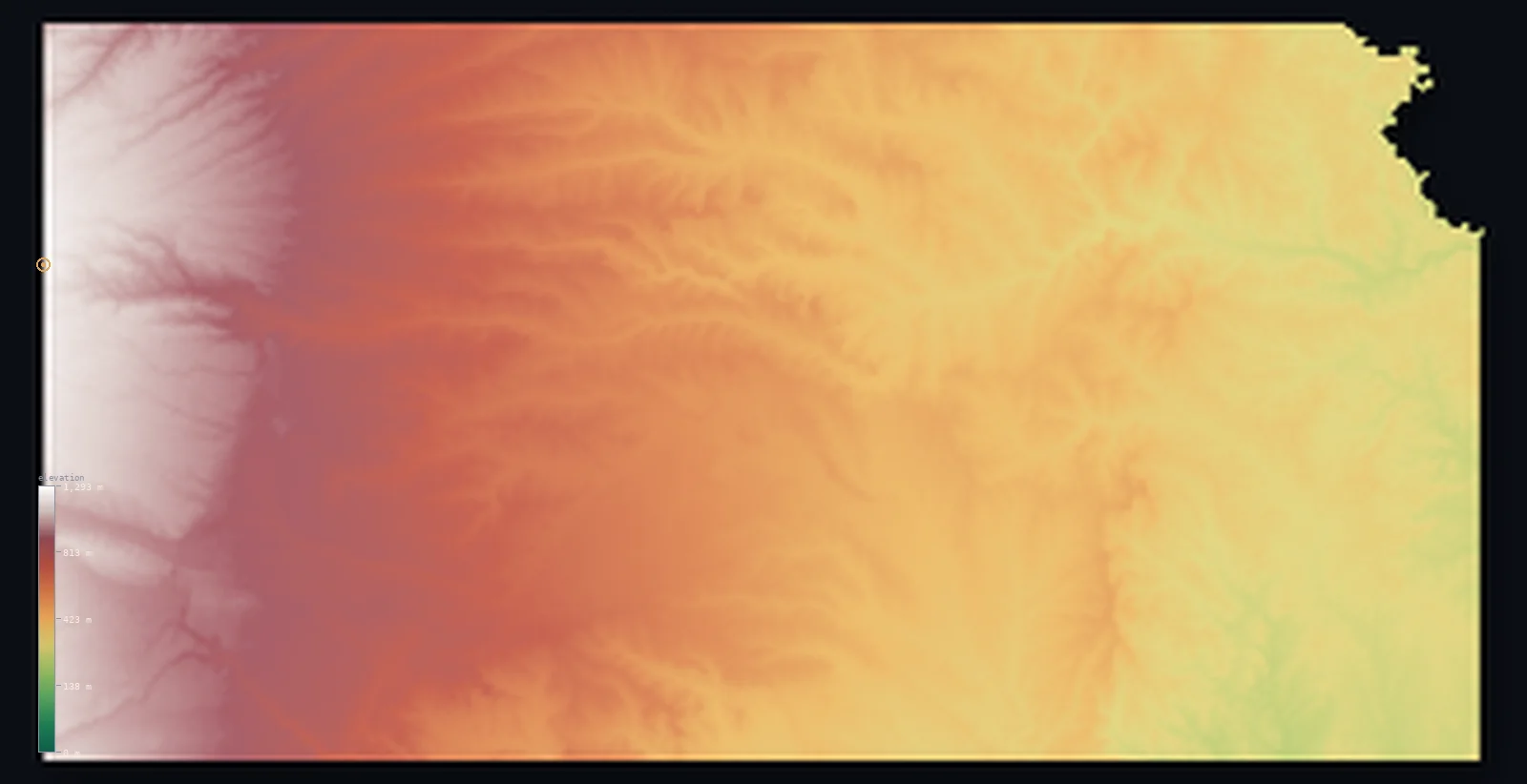
Kansas’s highest point is Mount Sunflower at 4,042 ft (1,232 m); its lowest is Verdigris River at 679 ft (207 m); the mean elevation is 1,909 ft (582 m).
- Highest point📚
- 4,042 ft1,232 m
- Mount Sunflower.
- Lowest point📚
- 679 ft207 m
- Verdigris River.
- Mean elevation⚙
- 1,909 ft582 m
- Computed from the GLO-30 surface model.
- Median elevation⚙
- 1,660 ft506 m
- Half of Kansas lies below this height.
- Elevation range📚
- 3,363 ft1,025 m
- From 207 m to Mount Sunflower's 1232 m.
- Above 1,000 m (3,281 ft)⚙
- 8%
- The state's higher ground.
- Official area📚
- 82,278 mi²213,100 km²
- Kansas.
Kansas at a glance
Mount Sunflower, the high point, is a gentle rise in a cattle pasture - western Kansas is simply high, not mountainous.
source ↗The Flint Hills hold the largest surviving tallgrass prairie in North America.
source ↗Kansas rises steadily from about 207 m in the east to 1,232 m in the west - a full kilometre of gentle tilt.
source ↗The geographic centre of the contiguous United States lies in northern Kansas.
source ↗Despite its flat reputation, Kansas is measurably less flat than several other states.
source ↗
Elevation profile of Kansas
The largest share of land, 21%, falls in the 300–400 m band, with the land split almost evenly above and below 500 m (1,640 ft).
- below 500 m (1,640 ft)49%
- 500–1,000 m42%
- 1,000–2,000 m8%
Highest and lowest points
The highest point of Kansas, Mount Sunflower, 1,232 m, a gentle swell of ranchland right on the Colorado border - not a mountain at all, but the high western edge of the Great Plains as they rise toward the Rockies.
source ↗Highest peaks of Kansas
| Peak | Elevation | Range | Note |
|---|---|---|---|
| Mount Sunflower↗ | 4,042 ft1,232 m | High Plains | Highest point of Kansas, a gentle plains rise. |
| Weskan Rise↗ | 4,026 ft1,227 m | High Plains | A high point of far western Kansas near Sunflower. |
| Arikaree Breaks↗ | 3,609 ft1,100 m | High Plains | Rugged eroded breaks in the far northwest. |
| Smoky Hills highpoint↗ | 2,297 ft700 m | Smoky Hills | A high point of the central sandstone hills. |
| Flint Hills highpoint↗ | 1,673 ft510 m | Flint Hills | A high point of the tallgrass Flint Hills. |
Terrain regions of Kansas
Mount Sunflower, the high point, is a gentle rise in a cattle pasture - western Kansas is simply high, not mountainous. ↗
The High Plains
↗Western Kansas is High Plains - a vast, gently rising tableland climbing steadily toward the Rockies. It reaches Mount Sunflower (1,232 m) at the Colorado line,
The Smoky Hills and central plains
↗Central Kansas rolls in low hills and river valleys - the Smoky Hills of sandstone and chalk, the Red Hills, and the great bend of the Arkansas River. This is t
The Flint Hills and eastern lowlands
↗Eastern Kansas holds the Flint Hills, the largest remaining stretch of tallgrass prairie in North America, their rocky soil having spared them from the plow. Be
The High Plains
the westWestern Kansas is High Plains - a vast, gently rising tableland climbing steadily toward the Rockies. It reaches Mount Sunflower (1,232 m) at the Colorado line, the state high point, which despite its name is just a low swell in the wheat and grass, over a kilometre above eastern Kansas.
The Smoky Hills and central plains
the centreCentral Kansas rolls in low hills and river valleys - the Smoky Hills of sandstone and chalk, the Red Hills, and the great bend of the Arkansas River. This is transitional country between the high dry west and the greener east.
The Flint Hills and eastern lowlands
the eastEastern Kansas holds the Flint Hills, the largest remaining stretch of tallgrass prairie in North America, their rocky soil having spared them from the plow. Beyond them the land drops into the greener eastern lowlands and river valleys, reaching the state's lowest point on the Verdigris River at 207 m.
City elevations in Kansas
| City | Population | Elevation |
|---|---|---|
| Wichita | 396,119 | 1,306 ft398 m |
| Overland Park | 186,515 | 1,086 ft331 m |
| Topeka | 125,963 | 945 ft288 m |
| Manhattan | 56,308 | 1,033 ft315 m |
| Salina | 47,813 | 1,234 ft376 m |
| Hutchinson | 41,569 | 1,539 ft469 m |
| Dodge City | 27,912 | 2,500 ft762 m |
| Garden City | 27,005 | 2,848 ft868 m |
| Emporia | 24,649 | 1,152 ft351 m |
| Hays | 21,092 | 2,018 ft615 m |
Elevation sampled at each city centre from the Copernicus GLO-30 model. Cities and population from GeoNames (CC-BY 4.0).
Kansas in comparison
Kansas's terrain rises 3,363 ft (1,025 m) from Verdigris River (679 ft (207 m)) to Mount Sunflower — about 12% of the height of Mount Everest, the world's highest point at 29,032 ft (8,849 m).
Frequently asked questions
What is the highest point in Kansas?
- Mount Sunflower, 4,042 ft (1,232 m).
What is the average elevation of Kansas?
- About 610 m according to the USGS; this page also reports the area-weighted mean computed from the Copernicus GLO-30 model, 1,909 ft (582 m).
What is the lowest point in Kansas?
- Verdigris River, 679 ft (207 m).
Mount Sunflower?
- Mount Sunflower, the high point, is a gentle rise in a cattle pasture - western Kansas is simply high, not mountainous.
Where is the highest ground in Kansas?
- Western Kansas is High Plains - a vast, gently rising tableland climbing steadily toward the Rockies. It reaches Mount Sunflower (1,232 m) at the Colorado line, the state high point, which despite its
Is this a topographic, relief, contour, or elevation map of Kansas?
- They describe the same thing - terrain height. This page renders Kansas's actual elevation surface in interactive 3D (a relief or topographic view) and reports the statistics computed from it; a contour map shows the same data as lines of equal height.
About this map
The terrain is rendered from the Copernicus GLO-30 digital elevation model (ESA), masked to the US-KS boundary from geoBoundaries (gbOpen). Elevation statistics are computed directly from the model; peak names and researched facts are sourced and cited. See the methodology for the full pipeline.
Our area-weighted mean, computed from the Copernicus GLO-30 model, is 1,909 ft (582 m); the figure commonly cited elsewhere is 2,001 ft (610 m) (U.S. Geological Survey). Kansas's mean elevation is about 610 m; the page reports the area-weighted figure computed from the Copernicus GLO-30 model.
Surveyed national figures: official area · high point.
Rendered from Copernicus GLO-30 (ESA, 2021 release), boundaries from geoBoundaries. Generated 2026-07-14.