Washington Elevation Map
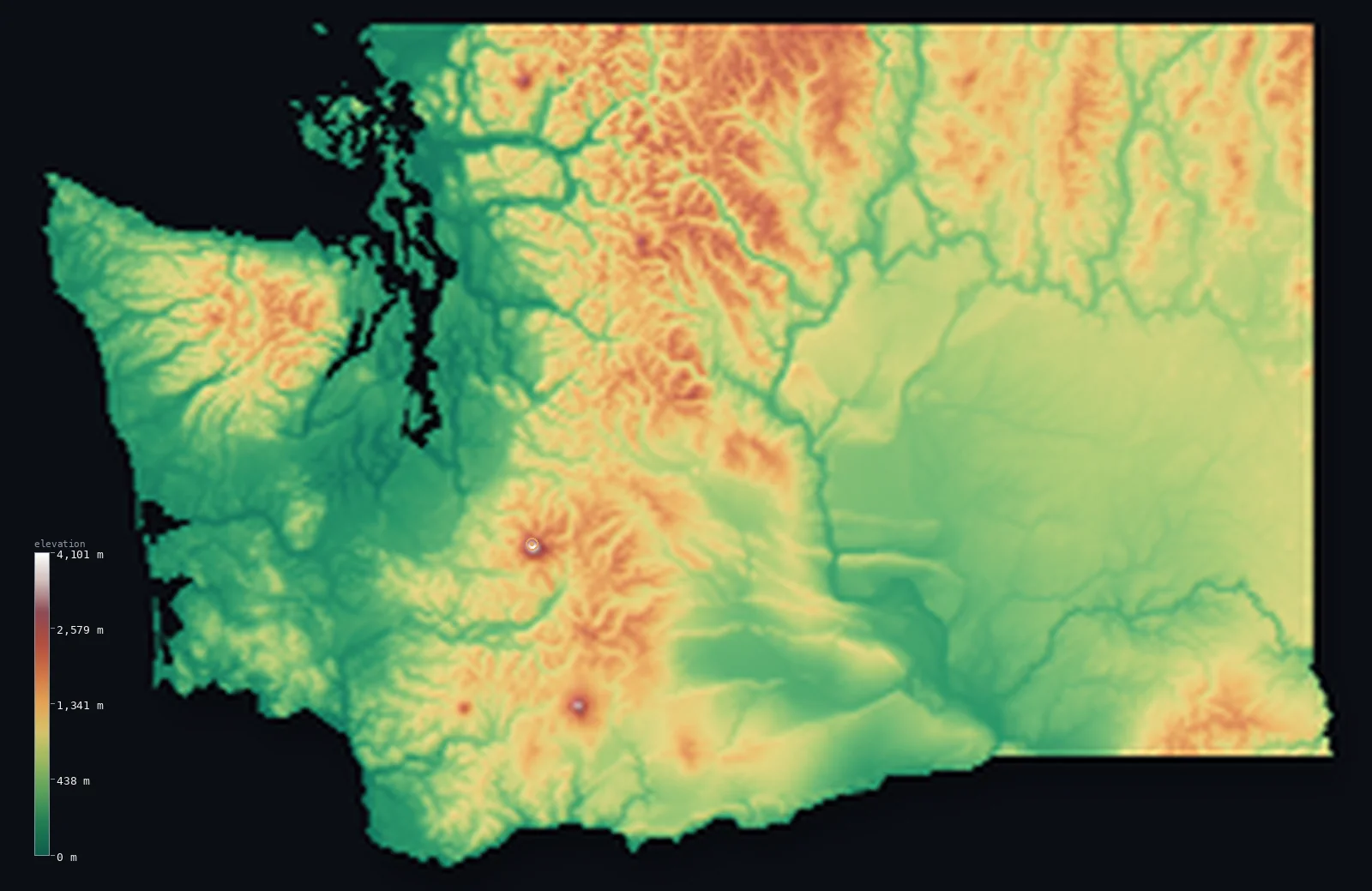
Washington’s highest point is Mount Rainier at 14,409 ft (4,392 m); its lowest is Pacific Ocean at 0 ft (0 m); the mean elevation is 2,290 ft (698 m).
- Highest point📚
- 14,409 ft4,392 m
- Mount Rainier, a Cascade volcano southeast of Seattle.
- Lowest point📚
- 0 ft0 m
- Sea level on the Pacific coast.
- Mean elevation⚙
- 2,290 ft698 m
- Computed from the GLO-30 surface model across the state.
- Median elevation⚙
- 2,080 ft634 m
- Half of Washington lies below this height.
- Elevation range📚
- 14,409 ft4,392 m
- From the Pacific to Rainier's 4,392 m.
- Above 1,000 m (3,281 ft)⚙
- 24%
- The Cascade Range and the Olympic Mountains.
- Above 2,000 m (6,562 ft)⚙
- 1%
- The high Cascade volcanoes and the Olympics.
- Official area📚
- 71,298 mi²184,661 km²
- A state of coastal ranges, a great volcanic spine and a dry interior.
Washington at a glance
Mount Rainier is the most heavily glaciated peak in the contiguous United States.
source ↗Rainier is an active volcano and one of the most topographically prominent mountains in the country.
source ↗The Olympic Peninsula holds temperate rainforest, among the rainiest places in the lower 48.
source ↗The Cascades split the state into a wet green west and a dry brown east.
source ↗Ice Age megafloods carved the channeled scablands into the eastern basalt plateau.
source ↗
Elevation profile of Washington
The largest share of land, 39%, falls in the 0–500 m band, and 61% of the territory lies above 500 m (1,640 ft).
- below 500 m (1,640 ft)39%
- 500–1,000 m37%
- 1,000–2,000 m23%
- above 2,000 m (6,562 ft)1%
Highest and lowest points
The highest point of Washington, Mount Rainier, 4,392 m, a glacier-clad active stratovolcano in the Cascade Range southeast of Seattle. It is the most heavily glaciated peak in the contiguous United States and one of the most topographically prominent mountains in the country, towering nearly 4 km above its surroundings.
source ↗Highest peaks of Washington
| Peak | Elevation | Range | Note |
|---|---|---|---|
| Mount Rainier↗ | 14,409 ft4,392 m | Cascade Range | Highest point of Washington, a glaciated active volcano. |
| Mount Adams↗ | 12,280 ft3,743 m | Cascade Range | The second-highest peak in Washington, a broad volcano in the south Cascades. |
| Mount Baker↗ | 10,781 ft3,286 m | Cascade Range | A heavily glaciated volcano in the far north Cascades. |
| Glacier Peak↗ | 10,541 ft3,213 m | Cascade Range | A remote volcano deep in the North Cascades wilderness. |
| Mount Olympus↗ | 7,979 ft2,432 m | Olympic Mountains | The highest peak of the Olympic Mountains on the western peninsula. |
Terrain regions of Washington
Mount Rainier is the most heavily glaciated peak in the contiguous United States. ↗
The coast and Olympics
↗The wet Pacific coast and the rugged Olympic Mountains of the northwestern peninsula, some of the rainiest country in the contiguous US.
The Puget lowland and Cascades
↗The lowland trough of Puget Sound holding Seattle, and behind it the high Cascade Range with its chain of glaciated volcanoes led by Mount Rainier.
The Columbia Plateau
↗The dry inland east - the Columbia Plateau of basalt and the Palouse hills, in the rain shadow of the Cascades.
The coast and Olympic Mountains
the northwest peninsula and coastWestern Washington faces the Pacific with a rugged, rain-drenched coast backed by the Olympic Mountains, a compact, steep range rising to Mount Olympus (2,432 m). Their western slopes catch enormous rainfall and hold temperate rainforest, among the wettest places in the contiguous United States, while their eastern side lies in a sharp rain shadow.
The Puget lowland and the Cascades
the west-centreBetween the Olympics and the Cascades lies the Puget Sound lowland, a glacier-carved trough of inlets and islands holding Seattle and most of the state's people. East of it rises the Cascade Range, a high volcanic spine crowned by a line of glacier-clad stratovolcanoes - Rainier (4,392 m), Adams, Baker, Glacier Peak and, further south, the truncated cone of Mount St. Helens. Rainier is the most heavily glaciated peak in the lower 48.
The Columbia Plateau and eastern hills
the eastEast of the Cascades the climate flips to dry. The Columbia Plateau is a vast sheet of ancient basalt lava, scoured by Ice Age megafloods into the coulees and channeled scablands and cut by the Columbia River. In the southeast rise the rolling wheatlands of the Palouse, and in the far northeast the land climbs into forested mountains toward Idaho.
City elevations in Washington
| City | Population | Elevation |
|---|---|---|
| SeattleSeattle sits on Puget Sound in the western lowland, with Mount Rainier looming to the southeast. ↗ | 780,995 | 194 ft59 m |
| Tri-Cities | 244,036 | 361 ft110 m |
| Spokane | 229,447 | 1,818 ft554 m |
| Vancouver | 196,442 | 180 ft55 m |
| Yakima | 93,701 | 1,070 ft326 m |
| Bellingham | 85,146 | 75 ft23 m |
| Marysville | 66,773 | 23 ft7 m |
| Lakewood | 59,829 | 266 ft81 m |
| Longview | 36,848 | 26 ft8 m |
| Wenatchee | 33,636 | 673 ft205 m |
Elevation sampled at each city centre from the Copernicus GLO-30 model. Cities and population from GeoNames (CC-BY 4.0).
Washington in comparison
Washington's terrain rises 14,409 ft (4,392 m) from sea level to Mount Rainier — about 50% of the height of Mount Everest, the world's highest point at 29,032 ft (8,849 m).
Frequently asked questions
What is the highest point in Washington?
- Mount Rainier, 14,409 ft (4,392 m), a glaciated active volcano in the Cascade Range southeast of Seattle.
What is the average elevation of Washington?
- About 520 m according to the USGS; this page also reports the area-weighted mean computed from the Copernicus GLO-30 model, 2,290 ft (698 m).
What is the lowest point in Washington?
- Sea level, along the Pacific coast and Puget Sound.
Is Mount Rainier a volcano?
- Yes - it is an active stratovolcano and the most heavily glaciated peak in the contiguous US, towering nearly 4 km above its surroundings.
Why is eastern Washington so dry?
- The Cascade Range casts a strong rain shadow, so the western half is wet and green while the eastern Columbia Plateau is dry.
Is this a topographic, relief, contour, or elevation map of Washington?
- They describe the same thing - terrain height. This page renders Washington's actual elevation surface in interactive 3D (a relief or topographic view) and reports the statistics computed from it; a contour map shows the same data as lines of equal height.
About this map
The terrain is rendered from the Copernicus GLO-30 digital elevation model (ESA), masked to the US-WA boundary from geoBoundaries (gbOpen). Elevation statistics are computed directly from the model; peak names and researched facts are sourced and cited. See the methodology for the full pipeline.
This map renders 175,442 km² across 57 landmasses of Washington. One smaller outlying part — 0 km² in total — lies beyond the area shown here. Area statistics above count the full territory.
Our area-weighted mean, computed from the Copernicus GLO-30 model, is 2,290 ft (698 m); the figure commonly cited elsewhere is 1,706 ft (520 m) (U.S. Geological Survey). Washington spans the wet coastal ranges, the Puget lowland, the high volcanic Cascades and the dry inland plateau, giving a moderate mean of about 520 m; the page reports the area-weighted figure computed from the Copernicus GLO-30 model.
Surveyed national figures: official area · high point.
Rendered from Copernicus GLO-30 (ESA, 2021 release), boundaries from geoBoundaries. Generated 2026-07-13.