Hawaii Elevation Map
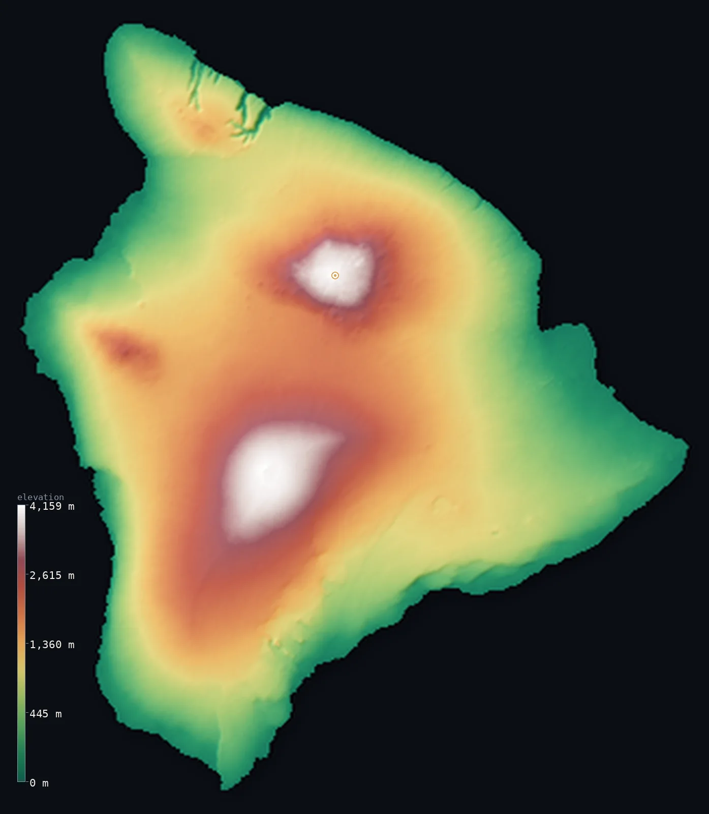
Hawaii’s highest point is Mauna Kea at 13,796 ft (4,205 m); its lowest is Pacific Ocean at 0 ft (0 m); the mean elevation is 3,904 ft (1,190 m).
- Highest point📚
- 13,796 ft4,205 m
- Mauna Kea, a shield volcano on the Big Island.
- Lowest point📚
- 0 ft0 m
- Sea level around every island.
- Mean elevation⚙
- 3,904 ft1,190 m
- Computed from the GLO-30 surface model across the islands.
- Median elevation⚙
- 3,307 ft1,008 m
- Half of Hawaii lies below this height.
- Elevation range📚
- 13,796 ft4,205 m
- From the sea to Mauna Kea's 4,205 m.
- Above 1,000 m (3,281 ft)⚙
- 50%
- The great shield volcanoes of the Big Island and Maui.
- Above 2,000 m (6,562 ft)⚙
- 19%
- Mauna Kea and Mauna Loa on the Big Island.
- Official area📚
- 10,932 mi²28,313 km²
- A chain of volcanic islands rising steeply from the Pacific.
Hawaii at a glance
Measured from its base on the ocean floor, Mauna Kea rises over 10,000 m - taller than Everest, the tallest mountain on Earth by that measure.
source ↗Neighbouring Mauna Loa is the most voluminous mountain on Earth.
source ↗The islands are the tops of a chain of volcanoes built as the Pacific plate drifts over a hot spot.
source ↗Kilauea, on the Big Island, is one of the most active volcanoes on Earth and still adds new land.
source ↗Puu Kukui on West Maui is among the wettest places on the planet.
source ↗
Elevation profile of Hawaii
The largest share of land, 28%, falls in the 0–500 m band, and 72% of the territory lies above 500 m (1,640 ft).
- below 500 m (1,640 ft)28%
- 500–1,000 m22%
- 1,000–2,000 m31%
- above 2,000 m (6,562 ft)19%
Highest and lowest points
The highest point of Hawaii, Mauna Kea, 4,205 m, a dormant shield volcano on the Big Island. Measured from its base on the ocean floor rather than from sea level it rises over 10,000 m - taller than Mount Everest - making it the tallest mountain on Earth by that measure.
source ↗Highest peaks of Hawaii
| Peak | Elevation | Range | Note |
|---|---|---|---|
| Mauna Kea↗ | 13,796 ft4,205 m | Hawaiian Islands (Big Island) | Highest point of Hawaii; tallest mountain on Earth measured from its ocean-floor base. |
| Mauna Loa↗ | 13,678 ft4,169 m | Hawaiian Islands (Big Island) | The most massive volcano on Earth by volume, and an active one. |
| Haleakala↗ | 10,023 ft3,055 m | Hawaiian Islands (Maui) | The vast shield volcano that forms most of the island of Maui. |
| Hualalai↗ | 8,271 ft2,521 m | Hawaiian Islands (Big Island) | A third active volcano of the Big Island, above Kona. |
| Puu Kukui↗ | 5,787 ft1,764 m | West Maui Mountains | The high point of the older West Maui volcano, one of the wettest spots on Earth. |
Terrain regions of Hawaii
Measured from its base on the ocean floor, Mauna Kea rises over 10,000 m - taller than Everest, the tallest mountain on Earth by that measure. ↗
The Big Island volcanoes
↗The youngest island, built from five volcanoes including Mauna Kea, Mauna Loa and the still-erupting Kilauea.
The central islands
↗Maui, Molokai, Lanai and Kahoolawe - older volcanoes, deeply eroded, with Haleakala the highest.
Oahu, Kauai and the northwest
↗The older western islands - Oahu with its eroded ranges, ancient Kauai, and the low atolls of the northwestern chain.
The Big Island and its volcanoes
the southeastThe southeastern end of the chain is the Big Island of Hawaii, the youngest and highest, built from overlapping shield volcanoes. Two of them, Mauna Kea (4,205 m) and Mauna Loa (4,169 m), are so massive they dwarf every other mountain in the Pacific; measured from the ocean floor, Mauna Kea is the tallest mountain on Earth. Kilauea, on the island's flank, is one of the world's most active volcanoes, still building new land.
Maui and the central islands
the centreNorthwest of the Big Island lie the older islands of Maui, Molokai, Lanai and Kahoolawe, remnants of once-great volcanoes now deeply cut by erosion. Maui is dominated by Haleakala, a huge shield volcano rising to 3,055 m with a vast summit depression, while the West Maui Mountains catch enough rain to make Puu Kukui one of the wettest places on the planet.
Oahu, Kauai and the northwestern chain
the northwestThe older western islands are lower and more eroded. Oahu, the most populous, is framed by two worn volcanic ranges; Kauai, the oldest main island, is cut by deep canyons and the sheer Na Pali cliffs. Beyond them the chain continues as the low reefs, atolls and rocks of the Northwestern Hawaiian Islands, the drowned stumps of ancient volcanoes stretching far across the Pacific.
City elevations in Hawaii
| City | Population | Elevation |
|---|---|---|
| HiloHilo sits on the wet eastern coast of the Big Island, beneath the huge slopes of Mauna Kea and Mauna Loa. ↗ | 43,263 | 82 ft25 m |
| Kailua-Kona | 11,975 | 16 ft5 m |
| Hawaiian Paradise Park | 11,404 | 148 ft45 m |
| Waimea | 9,212 | 2,667 ft813 m |
| Waikoloa | 4,806 | 883 ft269 m |
| Hawaiian Ocean View | 4,437 | 1,591 ft485 m |
| Captain Cook | 3,429 | 1,250 ft381 m |
| Volcano | 2,575 | 3,750 ft1,143 m |
| Honoka‘a | 2,258 | 1,093 ft333 m |
| Kapaau | 1,734 | 476 ft145 m |
Elevation sampled at each city centre from the Copernicus GLO-30 model. Cities and population from GeoNames (CC-BY 4.0).
Hawaii in comparison
Hawaii's terrain rises 13,796 ft (4,205 m) from sea level to Mauna Kea — about 48% of the height of Mount Everest, the world's highest point at 29,032 ft (8,849 m).
Frequently asked questions
What is the highest point in Hawaii?
- Mauna Kea, 13,796 ft (4,205 m), a dormant shield volcano on the Big Island.
Is Mauna Kea taller than Everest?
- Measured from its base on the ocean floor, yes - Mauna Kea rises over 10,000 m, taller than Everest, though its summit is only 4,205 m above sea level.
What is the average elevation of Hawaii?
- About 930 m according to the USGS; this page also reports the area-weighted mean computed from the Copernicus GLO-30 model, 3,904 ft (1,190 m).
What is the lowest point in Hawaii?
- Sea level, around every island.
How were the Hawaiian Islands formed?
- As the Pacific plate drifts over a stationary hot spot, each island is built by volcanoes in turn - so the southeast (the Big Island) is youngest and highest, the northwest oldest and lowest.
Is this a topographic, relief, contour, or elevation map of Hawaii?
- They describe the same thing - terrain height. This page renders Hawaii's actual elevation surface in interactive 3D (a relief or topographic view) and reports the statistics computed from it; a contour map shows the same data as lines of equal height.
About this map
The terrain is rendered from the Copernicus GLO-30 digital elevation model (ESA), masked to the US-HI boundary from geoBoundaries (gbOpen). Elevation statistics are computed directly from the model; peak names and researched facts are sourced and cited. See the methodology for the full pipeline.
This map renders 10,456 km² of Hawaii. 27 smaller outlying parts — 6,293 km² in total — lie beyond the area shown here. Area statistics above count the full territory.
Our area-weighted mean, computed from the Copernicus GLO-30 model, is 3,904 ft (1,190 m); the figure commonly cited elsewhere is 3,051 ft (930 m) (U.S. Geological Survey). Hawaii is a chain of volcanic islands whose great shield volcanoes lift its mean elevation to about 930 m despite being surrounded by ocean; the page reports the area-weighted figure computed from the Copernicus GLO-30 model.
Surveyed national figures: official area · high point.
Rendered from Copernicus GLO-30 (ESA, 2021 release), boundaries from geoBoundaries. Generated 2026-07-13.