Alaska Elevation Map
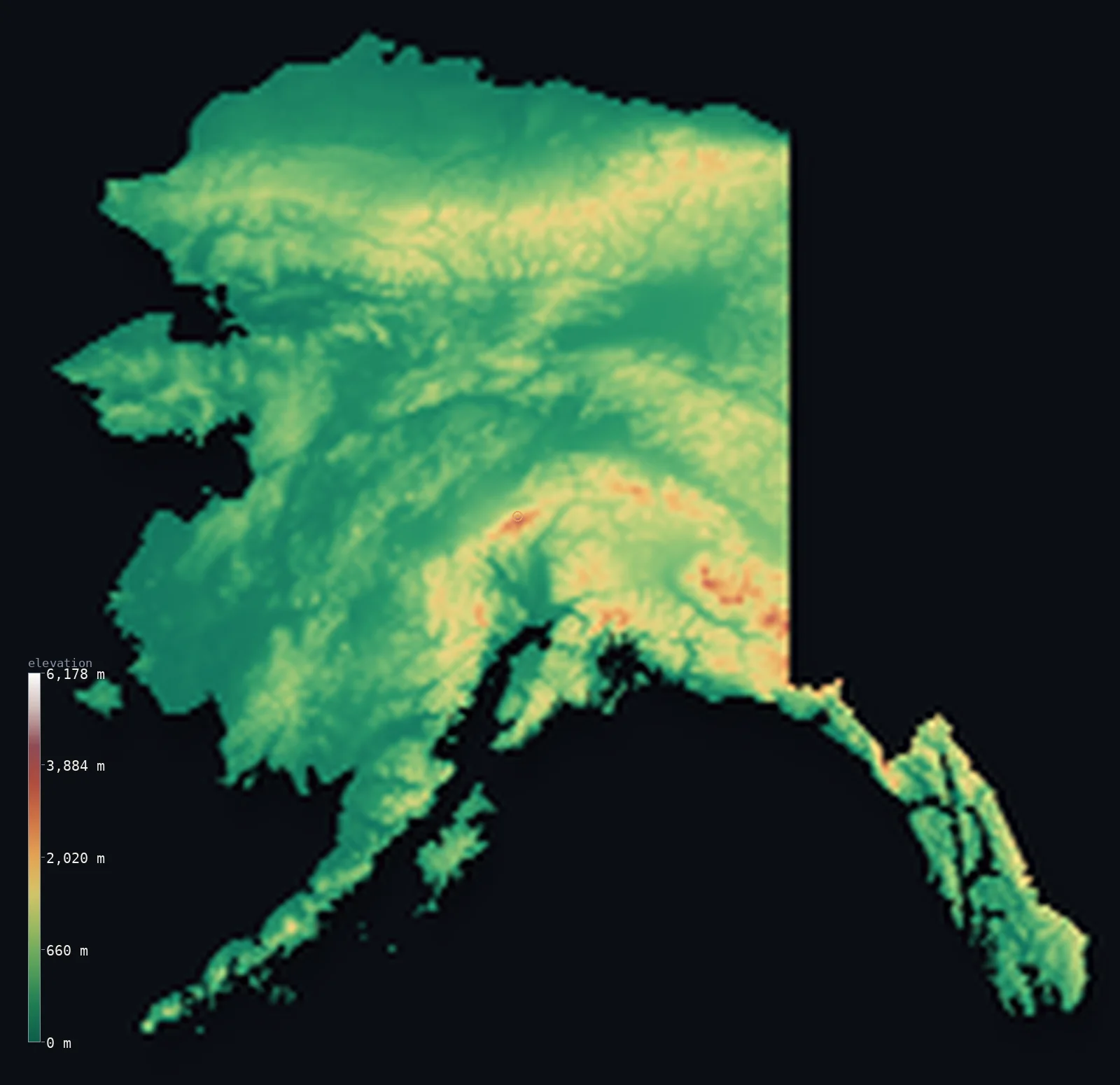
Alaska’s highest point is Denali at 20,308 ft (6,190 m); its lowest is Pacific Ocean at 0 ft (0 m); the mean elevation is 1,496 ft (456 m).
- Highest point📚
- 20,308 ft6,190 m
- Denali, in the Alaska Range of the interior.
- Lowest point📚
- 0 ft0 m
- Sea level, along the vast Pacific and Arctic coasts.
- Mean elevation⚙
- 1,496 ft456 m
- Computed from the GLO-30 surface model across the state.
- Median elevation⚙
- 961 ft293 m
- Half of Alaska lies below this height.
- Elevation range📚
- 20,308 ft6,190 m
- From the sea to Denali's 6,190 m.
- Above 1,000 m (3,281 ft)⚙
- 13%
- The Alaska Range, the Brooks Range and the coastal mountains.
- Above 2,000 m (6,562 ft)⚙
- 1%
- The high Alaska Range around Denali.
- Official area📚
- 665,384 mi²1,723,337 km²
- By far the largest state - mountains, tundra, glaciers and islands.
Alaska at a glance
Denali is the highest peak in North America and, from base to summit, one of the tallest mountains on Earth.
source ↗The ten highest mountains in the United States are all in Alaska.
source ↗The Aleutian Islands stretch so far west they cross the 180th meridian into the Eastern Hemisphere.
source ↗Alaska has more coastline than all the other US states combined.
source ↗The southern coast holds some of the largest glaciers and iciest mountains outside the polar regions.
source ↗
Elevation profile of Alaska
The largest share of land, 66%, falls in the 0–500 m band, and 66% of the territory lies below 500 m (1,640 ft).
- below 500 m (1,640 ft)66%
- 500–1,000 m20%
- 1,000–2,000 m12%
- above 2,000 m (6,562 ft)1%
Highest and lowest points
The highest point of Alaska - and of all North America - is Denali, 6,190 m, in the Alaska Range. Measured from its base rather than sea level it is one of the tallest mountains on Earth, and it is the highest point in the entire Arctic Ocean basin.
source ↗Highest peaks of Alaska
| Peak | Elevation | Range | Note |
|---|---|---|---|
| Denali↗ | 20,308 ft6,190 m | Alaska Range | Highest point of Alaska and of North America. |
| Mount Saint Elias↗ | 18,009 ft5,489 m | Saint Elias Mountains | The second-highest peak in Alaska, on the Yukon border. |
| Mount Foraker↗ | 17,402 ft5,304 m | Alaska Range | A great peak beside Denali. |
| Mount Bona↗ | 16,549 ft5,044 m | Saint Elias Mountains | A massive ice-covered volcano in the southeast. |
| Mount Blackburn↗ | 16,391 ft4,996 m | Wrangell Mountains | The highest peak of the Wrangell Mountains. |
Terrain regions of Alaska
Denali is the highest peak in North America and, from base to summit, one of the tallest mountains on Earth. ↗
The interior and Alaska Range
↗The central basins of the Yukon River between the Brooks Range and the Alaska Range, which carries Denali.
The Arctic north
↗The Brooks Range and the flat, treeless North Slope tundra descending to the Arctic Ocean.
The south coast and islands
↗The glaciated coastal mountains, the southeastern panhandle, and the long Aleutian island chain reaching across the Pacific.
The Alaska Range and interior
the centreCentral Alaska is a broad interior of low hills and the wide Yukon River basin, walled to the south by the Alaska Range - a great arc of mountains that lifts Denali (6,190 m), the highest point in North America, high enough to make its own weather. This is a land of extremes, baking in brief summers and freezing deep in winter.
The Arctic North Slope and Brooks Range
the northNorthern Alaska rises across the Brooks Range, the northernmost major mountain chain in the United States, and then falls away to the North Slope - a vast, flat, treeless tundra plain sloping to the frozen Arctic Ocean, underlain by permafrost and crossed by the caribou herds and the oil pipeline.
The coastal mountains and islands
the southSouthern Alaska is a rim of heavily glaciated coastal mountains - the Saint Elias, Wrangell and Chugach ranges, some of the most glaciated country outside the poles. The narrow southeastern panhandle is a maze of fjords and forested islands, and from the southwest the Alaska Peninsula tapers into the Aleutian Islands, a chain of volcanoes arcing far across the Pacific toward Asia.
City elevations in Alaska
| City | Population | Elevation |
|---|---|---|
| AnchorageAnchorage, the largest city, lies on Cook Inlet in the south-central lowlands, ringed by the Chugach Mountains. ↗ | 289,600 | 108 ft33 m |
| Fairbanks | 32,325 | 443 ft135 m |
| JuneauJuneau, the capital, sits on the mountainous southeastern panhandle, hemmed between steep peaks and the sea and reachable only by boat or plane. ↗ | 31,555 | 26 ft8 m |
| Sitka | 8,863 | 36 ft11 m |
| Ketchikan | 8,197 | 26 ft8 m |
| Bethel | 6,450 | 16 ft5 m |
| Kodiak | 6,253 | 26 ft8 m |
| Homer | 5,515 | 108 ft33 m |
| Utqiagvik | 4,384 | 26 ft8 m |
| Valdez | 3,870 | 16 ft5 m |
Elevation sampled at each city centre from the Copernicus GLO-30 model. Cities and population from GeoNames (CC-BY 4.0).
Alaska in comparison
Alaska's terrain rises 20,308 ft (6,190 m) from sea level to Denali — about 70% of the height of Mount Everest, the world's highest point at 29,032 ft (8,849 m).
Frequently asked questions
What is the highest point in Alaska?
- Denali, 20,308 ft (6,190 m), in the Alaska Range - also the highest point in all of North America.
What is the average elevation of Alaska?
- About 580 m according to the USGS; this page also reports the area-weighted mean computed from the Copernicus GLO-30 model, 1,496 ft (456 m).
What is the lowest point in Alaska?
- Sea level, along its enormous Pacific and Arctic coastlines.
Is Denali the tallest mountain in North America?
- Yes - at 6,190 m it is the highest peak on the continent, and from base to summit one of the tallest on Earth.
Why do the Aleutian Islands cross the map's edge?
- The Aleutians extend so far west they cross the 180th meridian into the Eastern Hemisphere - the map unwraps them to keep the chain continuous.
Is this a topographic, relief, contour, or elevation map of Alaska?
- They describe the same thing - terrain height. This page renders Alaska's actual elevation surface in interactive 3D (a relief or topographic view) and reports the statistics computed from it; a contour map shows the same data as lines of equal height.
About this map
The terrain is rendered from the Copernicus GLO-30 digital elevation model (ESA), masked to the US-AK boundary from geoBoundaries (gbOpen). Elevation statistics are computed directly from the model; peak names and researched facts are sourced and cited. See the methodology for the full pipeline.
This map renders 1,505,098 km² across 508 landmasses of Alaska. 80 smaller outlying parts — 17,553 km² in total — lie beyond the area shown here. Area statistics above count the full territory.
Our area-weighted mean, computed from the Copernicus GLO-30 model, is 1,496 ft (456 m); the figure commonly cited elsewhere is 1,903 ft (580 m) (U.S. Geological Survey). Alaska is by far the largest state, spanning the Arctic North Slope, the Brooks and Alaska ranges, and thousands of islands; its mean elevation is about 580 m. The page reports the area-weighted figure computed from the Copernicus GLO-30 model.
Surveyed national figures: official area · high point.
Rendered from Copernicus GLO-30 (ESA, 2021 release), boundaries from geoBoundaries. Generated 2026-07-13.