El Salvador Elevation Map — Topographic & 3D Terrain
Explore the terrain of El Salvador in interactive 3D, built from Copernicus GLO-30 satellite elevation data — the smallest, most crowded country in Central America, a volcanic land between mountains and the Pacific. Drag to rotate, scroll to zoom, and tap any point to read its elevation.
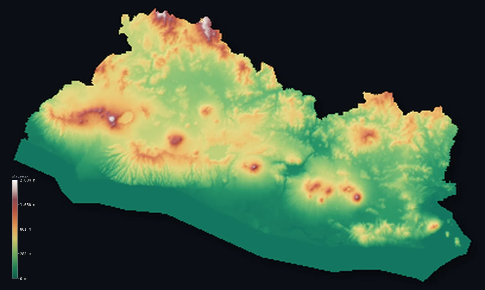
El Salvador’s highest point is Cerro El Pital at 8,957 ft (2,730 m); its lowest is Pacific Ocean at 0 ft (0 m); the mean elevation is 1,184 ft (361 m).
El Salvador is the smallest country in Central America, and the only one without a Caribbean coast — it faces the Pacific alone. It is a volcanic land: a narrow country running between two lines of high ground, with a chain of volcanoes, the 'Land of Volcanoes,' rising across its middle above a central plateau where most Salvadorans live. Along the northern border with Honduras runs a higher, non-volcanic mountain range, holding the country's highest point, Cerro El Pital, at 8,957 ft (2,730 m). Between the volcanoes and the sea lies a hot Pacific coastal plain. It is a country of real relief, but its high ground is a spine: about half of El Salvador lies below about 935 ft, on the coastal plain and in the central valleys.
- Highest point📚
- 8,957 ft2,730 m
- El Salvador's highest point is Cerro El Pital at 8,957 ft (2,730 m), on the northern border with Honduras — and, notably, it is not one of the country's famous volcanoes but a summit in the Sierra Madre, the non-volcanic mountain range along the Honduran frontier. Its peak sits on the border, so El Pital is shared with Honduras (where it is only the third-highest point); on the Salvadoran side it is the highest ground, a cool, forested summit high above the volcanic country to the south. The great volcanoes — Santa Ana, the highest at 7,812 ft (2,381 m), San Salvador, San Miguel — are lower.
- Lowest point📚
- 0 ft0 m
- El Salvador's lowest point is the Pacific Ocean at sea level, along the country's only coast — a hot, narrow coastal plain of beaches, mangroves, and farmland facing the Pacific. El Salvador has no Caribbean coast at all, the only Central American country so placed; from its single Pacific shore the land rises inland to the volcanoes and the northern mountains.
- Mean elevation⚙
- 1,184 ft361 m
- Computed from the GLO-30 model, El Salvador's mean elevation is 1,184 ft (361 m) — raised by the volcanic chain across the centre and the non-volcanic range along the Honduran border. But these are narrow bands of high ground, not the whole country: about half of El Salvador lies below about 935 ft (285 m), on the Pacific coastal plain and in the central valleys between them.
- Median elevation⚙
- 935 ft285 m
- Half of El Salvador lies below about 935 ft (285 m) — because its height is gathered in the chain of volcanoes across the centre and the non-volcanic range along the northern border, with the central plateau, the valleys, and the Pacific coastal plain lying lower between and below them. The volcanoes are high, but they are a spine, not the surface.
- Elevation range📚
- 8,957 ft2,730 m
- From the Pacific coast to the summit of Cerro El Pital at 2,730 m, El Salvador's terrain climbs about 8,957 ft — from a hot Pacific shore, up across a volcanic country of cones and high valleys, to the cool non-volcanic mountains of the Honduran border, all within a small and crowded land.
- Above 1,000 m (3,281 ft)⚙
- 5%
- About 5% of El Salvador rises above 1,000 m (3,281 ft) — the higher volcanoes, the northern Sierra Madre along the Honduran border (holding Cerro El Pital), and the higher parts of the central highlands. The Pacific coastal plain and the lower valleys lie below.
- Official area📚
- 8,124 mi²21,041 km²
- El Salvador covers about 8,124 sq mi (21,041 sq km) — the smallest country in Central America and the only one without a Caribbean coast, a volcanic land of a central chain of volcanoes (the 'Land of Volcanoes') above a populous plateau, a non-volcanic northern range along the Honduran border (holding Cerro El Pital), and a hot Pacific coastal plain.
- Forest cover📚
- 13.6%
- About 14% of El Salvador is forested — much reduced, for El Salvador is the most densely populated and heavily farmed country in Central America; coffee grows on the volcanic highland slopes, with pine and cloud forest on the high northern mountains and mangroves along the Pacific coast.
Highest and lowest points
El Salvador's highest point is Cerro El Pital, 8,957 ft (2,730 m), on the northern border with Honduras. It is easy to assume the high point of the 'Land of Volcanoes' must be a volcano — but it is not: El Pital is a summit of the Sierra Madre, the older, non-volcanic mountain range that runs along El Salvador's northern frontier, cooler and forested, with cloud forest near its top. Its summit lies right on the border, so El Pital is shared with Honduras, where it ranks only third-highest; but for El Salvador it is the highest ground. The country's famous volcanoes are all lower: Santa Ana (Ilamatepec), the highest of them, reaches 7,812 ft (2,381 m), with San Salvador, San Miguel (Chaparrastique), Izalco, and others rising across the centre of the country. So El Salvador's highest point is not among its volcanoes at all, but on the quiet northern mountains it shares with Honduras.
source ↗El Salvador's lowest point is the Pacific Ocean at sea level, along its single coast — a hot, narrow coastal plain of beaches, mangroves, estuaries, and farmland. El Salvador is unique in Central America in having no Caribbean coast: hemmed in by Guatemala and Honduras, it faces only the Pacific. From this shore the land rises inland. First comes a belt of coastal ranges and the great chain of volcanoes that gives the country its name, the 'Land of Volcanoes' — Santa Ana (the highest volcano), San Salvador above the capital, San Miguel, and others, active and dramatic, rising above a central plateau and valleys where most of the dense population lives. Then, along the northern border with Honduras, rises higher, older, non-volcanic mountains — the Sierra Madre — holding Cerro El Pital, the country's highest point. So El Salvador climbs from a single Pacific coast, across volcanic highlands, to cool border mountains — a small country of considerable relief.
source ↗El Salvador at a glance
El Salvador is the only Central American country without a Caribbean coast - hemmed in by Guatemala and Honduras, it faces only the Pacific.
source ↗El Salvador's highest point, Cerro El Pital (2,730 m), is not a volcano but a summit of the non-volcanic Sierra Madre on the Honduran border - where the country's famous volcanoes are all lower.
source ↗El Salvador is called the 'Land of Volcanoes' - a chain of volcanic cones (Santa Ana, San Salvador, San Miguel, Izalco) crosses the country, several of them active.
source ↗El Salvador is the smallest and most densely populated country in Central America - a small, crowded, heavily farmed land.
source ↗The volcano Izalco, which grew from a vent in the 1770s and erupted almost continuously for nearly two centuries, was once known as the 'Lighthouse of the Pacific.'
source ↗About half of El Salvador lies low - on the Pacific coastal plain and in the central valleys - with the high ground gathered in the volcanic chain and the northern border mountains.
source ↗
Elevation profile of El Salvador
The largest share of land, 42%, falls in the 0–200 m band, and 69% of the territory lies below 500 m (1,640 ft).
- below 500 m (1,640 ft)69%
- 500–1,000 m26%
- 1,000–2,000 m5%
- above 2,000 m (6,562 ft)<1%
Highest peaks of El Salvador
| Peak | Elevation | Range | Note |
|---|---|---|---|
| Cerro El Pital↗ | 8,957 ft2,730 m | Sierra Madre (Honduras border) | Highest point of El Salvador, a cloud-forest summit shared with Honduras. |
| Santa Ana (Ilamatepec)↗ | 7,812 ft2,381 m | Apaneca-Ilamatepec volcanic range | The highest volcano in El Salvador, an active stratovolcano above the Coatepeque caldera. |
| San Miguel (Chaparrastique)↗ | 6,988 ft2,130 m | eastern volcanic chain | One of the country's most active volcanoes, a near-symmetrical cone in the east. |
| Izalco↗ | 6,398 ft1,950 m | Apaneca-Ilamatepec volcanic range | A young volcano nicknamed the 'Lighthouse of the Pacific' for the glow of its long eruptions. |
| San Salvador (volcano)↗ | 6,211 ft1,893 m | central volcanic chain | The volcano overlooking the capital, capable of major harm to the city on its slopes. |
El Salvador: the volcanic highlands, the northern mountains, and the Pacific coast
The volcanic highlands — the centre
Across the middle of El Salvador runs the 'Land of Volcanoes' — a chain of volcanic cones (Santa Ana, San Salvador, San Miguel, Izalco), several active, rising above a central plateau and valleys where most of the dense population lives. The country's volcanic, populous heart.
The northern mountains — the Honduran border
Along the northern border with Honduras rise higher, older, non-volcanic mountains — the Sierra Madre, cooler and forested, holding Cerro El Pital (the high point). The country's highest, coolest ground.
The Pacific coastal plain
Between the volcanoes and the sea lies a hot, narrow Pacific coastal plain — beaches, mangroves, estuaries, and farmland along El Salvador's single coast. The low, warm seaward edge.
How to read this map
Color shows elevation; the raised relief shows real terrain. On this map El Salvador reads as a small country with its height in two lines — the volcanic cones standing across the centre (the 'Land of Volcanoes', above the central plateau), the higher non-volcanic mountains along the northern Honduran border (highest at Cerro El Pital), and the low green of the Pacific coastal plain along the south, with the central valleys between.
The 3D relief is the actual GLO-30 elevation data, exaggerated vertically so the volcanoes, the border mountains, and the coast all show; the ×N relief slider controls how much. Tap anywhere to read that point's exact elevation.
City elevations in El Salvador
El Salvador's cities cluster in the central highlands and valleys — San Salvador, the capital, in a volcanic basin below its namesake volcano, with Santa Ana and San Miguel near their own volcanoes and others across the densely settled centre. Most of the population lives in the central highland belt, between the coast and the northern mountains.
| City | Population | Elevation |
|---|---|---|
| San Salvadorcapitalthe capital, in a volcanic basin below San Salvador volcano ↗ | 525,990 | 2,133 ft650 m |
| San Miguelin the east, below San Miguel volcano ↗ | 247,126 | 413 ft126 m |
| Santa Anain the west, below Santa Ana volcano (the highest) ↗ | 176,661 | 2,165 ft660 m |
| Sonsonatein the west, toward the Pacific coast ↗ | 59,468 | 758 ft231 m |
| Usulutánin the southeast, near the coastal plain ↗ | 51,910 | 292 ft89 m |
| Cojutepequein the central highlands, east of San Salvador ↗ | 48,411 | 2,835 ft864 m |
| Zacatecolucaon the southern coastal plain ↗ | 39,613 | 676 ft206 m |
| Ahuachapánin the far west, near the Guatemalan border ↗ | 34,102 | 2,625 ft800 m |
| La Uniónon the Gulf of Fonseca in the far east ↗ | 26,807 | 16 ft5 m |
| Aguilaresin the central highlands, north of San Salvador ↗ | 21,445 | 988 ft301 m |
Elevation sampled at each city centre from the Copernicus GLO-30 model. Cities and population from GeoNames (CC-BY 4.0).
El Salvador in comparison
El Salvador's terrain rises 8,957 ft (2,730 m) from sea level to Cerro El Pital — about 31% of the height of Mount Everest, the world's highest point at 29,032 ft (8,849 m).
- Guatemala's mean elevation is 2,444 ft — 1,260 ft higher; its high point, Volcan Tajumulco, reaches 13,845 ft (4,220 m), 4,888 ft above. Guatemala elevation map →
- Honduras's mean elevation is 2,060 ft — 876 ft higher; its high point, Cerro Las Minas (Pico Celaque), reaches 9,416 ft (2,870 m), 459 ft above. Honduras elevation map →
- Nicaragua's mean elevation is 728 ft — 456 ft lower; its high point, Mogoton, reaches 6,913 ft (2,107 m), 2,044 ft below. Nicaragua elevation map →
Frequently asked questions
What is the highest point in El Salvador?
- Cerro El Pital, 8,957 ft (2,730 m), on the northern border with Honduras - not a volcano, but a summit of the non-volcanic Sierra Madre; the country's famous volcanoes are all lower.
What is the lowest point in El Salvador?
- The Pacific Ocean at sea level, along the country's single coast - El Salvador has no Caribbean coast, the only Central American country so placed.
What is the average elevation of El Salvador?
- Computed from the Copernicus GLO-30 model, the area-weighted mean is 1,184 ft (361 m) - raised by the volcanic chain and the northern border range. About half the country sits lower, below 935 ft (285 m), on the Pacific coastal plain and in the central valleys.
Is El Salvador's highest point a volcano?
- No - despite being the 'Land of Volcanoes,' El Salvador's highest point, Cerro El Pital (2,730 m), is a non-volcanic summit of the Sierra Madre on the Honduran border. Its highest volcano, Santa Ana, is lower at 2,381 m.
Why does El Salvador have no Caribbean coast?
- It is hemmed in by Guatemala and Honduras, which take up the Caribbean side - so El Salvador, alone in Central America, faces only the Pacific.
Is this a topographic, relief, contour, or elevation map of El Salvador?
- They describe the same thing - terrain height. This page renders the country's actual elevation surface in interactive 3D and reports the statistics computed from it.
About this map
The terrain is rendered from the Copernicus GLO-30 digital elevation model (ESA), masked to the SLV-ADM0 boundary from geoBoundaries (gbOpen). Elevation statistics are computed directly from the model; peak names and researched facts are sourced and cited. See the methodology for the full pipeline.
Our area-weighted mean, computed from the Copernicus GLO-30 model, is 1,184 ft (361 m); the figure commonly cited elsewhere is 1,450 ft (442 m) (CIA World Factbook). El Salvador is a small, crowded, volcanic country, and its high ground runs in two lines. Across the centre stretches the 'Land of Volcanoes' — a chain of cones (Santa Ana, San Salvador, San Miguel) rising above the populous central plateau — and along the northern border with Honduras runs a higher, non-volcanic range holding the high point, Cerro El Pital. But between and below these lines lie the central valleys and the hot Pacific coastal plain, and these lower lands hold about half the country, so half of El Salvador lies below about 935 ft (285 m). So although El Salvador has real mountains, most of its people live on ground that sits below that average — the plateau, the valleys, and the Pacific plain. The mean here is computed directly from the GLO-30 elevation surface, and runs below the higher figure quoted in some other references.
Surveyed national figures: official area · forest cover · high point.
Rendered from Copernicus GLO-30 (ESA, 2021 release), boundaries from geoBoundaries. Generated 2026-06-22.
Bordering countries · 2
El Salvador shares a land border with these countries — open any one to compare its terrain and highest point.