Belize Elevation Map — Topographic & 3D Terrain
Explore the terrain of Belize in interactive 3D, built from Copernicus GLO-30 satellite elevation data — a low, forested Caribbean country of coastal plain and reef, rising to the Maya Mountains. Drag to rotate, scroll to zoom, and tap any point to read its elevation.
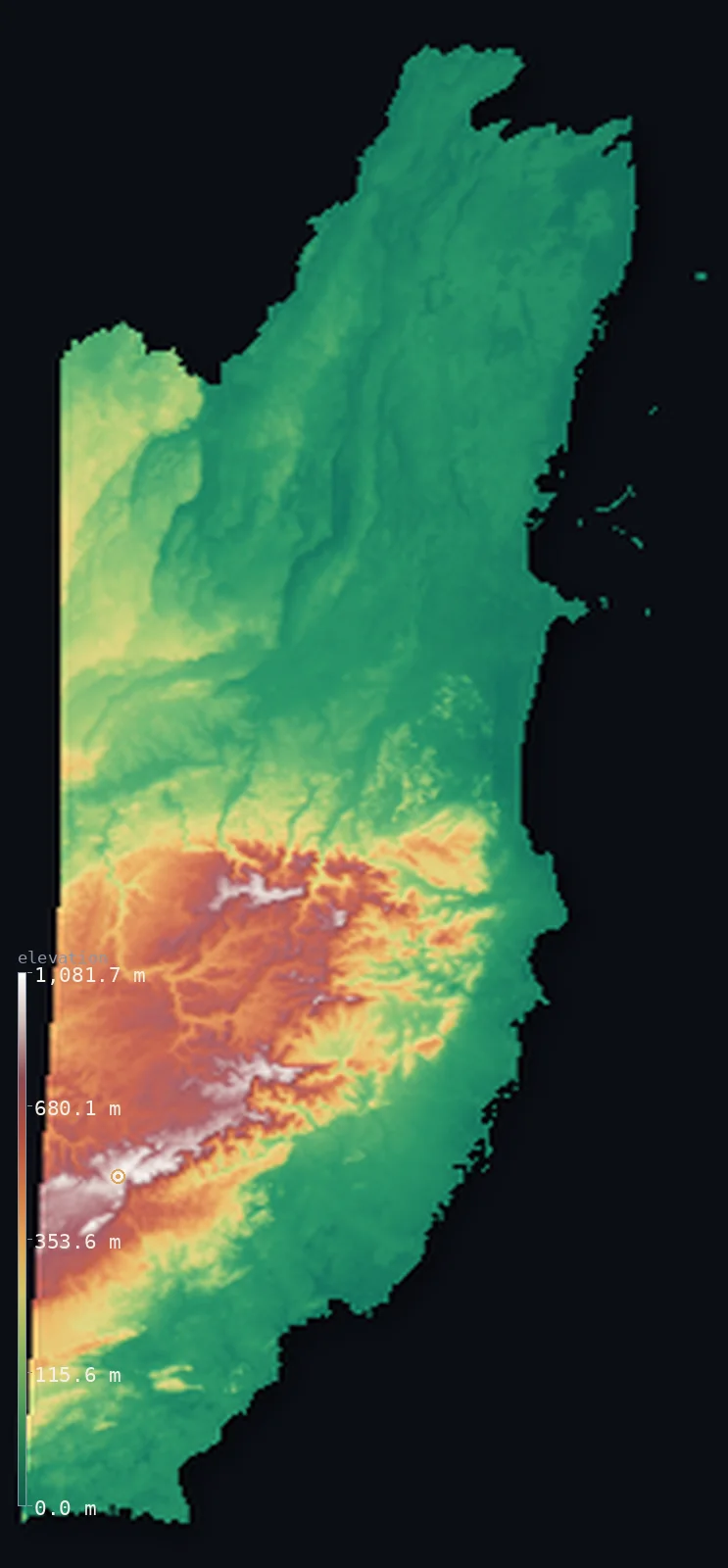
Belize’s highest point is Doyle's Delight at 3,688 ft (1,124 m); its lowest is Caribbean Sea at 0 ft (0 m); the mean elevation is 539 ft (164 m).
Belize is a small, low, thinly peopled country on the Caribbean coast of Central America — English-speaking, and long tied to the Caribbean more than to its Spanish-speaking neighbours. Most of it is low: a broad, flat coastal plain of swamp, savanna, and forest runs along the Caribbean, and offshore lies the great Belize Barrier Reef, the largest in the northern hemisphere, with its cayes and atolls. Only in the south-centre does the land rise, into the Maya Mountains — a low, ancient massif of forested ridges holding the country's highest point, Doyle's Delight, at 3,688 ft (1,124 m). Belize is one of the flattest and emptiest countries in the region: half of it lies below about 120 ft, in the coastal lowlands and forests.
- Highest point📚
- 3,688 ft1,124 m
- Belize's highest point is Doyle's Delight at 3,688 ft (1,124 m), in the Maya Mountains of the south-centre — a low, ancient, forested massif, the only real high ground in an otherwise low country. Doyle's Delight is a remote, rainforest-covered summit deep in the range, barely higher than the nearby Victoria Peak, the massif's more prominent landmark. The Maya Mountains are old, worn ridges of hard rock, rising from the surrounding lowlands but nowhere reaching great height.
- Lowest point📚
- 0 ft0 m
- Belize's lowest point is the Caribbean Sea at sea level, along a low, swampy coast — and much of Belize lies only a little above it: a broad, flat coastal plain of mangrove, swamp, savanna, and forest, fringed offshore by the cayes and the great barrier reef. Only inland and to the south does the land rise from these lowlands.
- Mean elevation⚙
- 539 ft164 m
- Computed from the GLO-30 model, Belize's mean elevation is 539 ft (164 m) — kept low by the broad Caribbean lowland that is most of the country: flat plains of swamp, savanna, and forest, with only the Maya Mountains in the south-centre rising to any real height. Half of Belize lies below about 124 ft (37.8 m), in those coastal lowlands and forests.
- Median elevation⚙
- 124 ft37.8 m
- Half of Belize lies below about 124 ft (37.8 m) — a strikingly low midpoint, because Belize is a country of lowland and reef: flat coastal plain, swamp, savanna, and forest make up nearly all of it, and only the Maya Mountains of the south-centre climb well above. The rest is low, green, and close to the sea.
- Elevation range📚
- 3,688 ft1,124 m
- From the Caribbean coast to the summit of Doyle's Delight at 1,124 m, Belize's terrain climbs about 3,688 ft — but most of the country is low: the rise is confined to the Maya Mountains in the south-centre, above the broad, flat coastal lowlands that make up the rest of Belize.
- Above 50 m (164 ft)⚙
- 46%
- About 46% of Belize rises above 164 ft (50 m) — chiefly the Maya Mountains in the south-centre and the gently rising land around them. The broad coastal plain along the Caribbean, much of the country, lies below.
- Official area📚
- 8,867 mi²22,966 km²
- Belize covers about 8,867 sq mi (22,966 sq km) — a small, low country on the Caribbean coast of Central America, of a broad, flat coastal plain of swamp, savanna, and forest (fringed by the cayes and the great Belize Barrier Reef), rising only in the south-centre to the low, forested Maya Mountains (holding Doyle's Delight).
- Forest cover📚
- 59.1%
- About 59% of Belize is forested — one of the most forested countries in Central America, thinly peopled and green, with broadleaf rainforest across the Maya Mountains and the interior, pine savanna on the coastal lowlands, and mangroves along the swampy coast and cayes.
Highest and lowest points
Belize's highest point is Doyle's Delight, 3,688 ft (1,124 m), a remote, rainforest-covered summit deep in the Maya Mountains of southern Belize. The Maya Mountains are an old, worn massif of hard rock — the only real high ground in an otherwise low and flat country — rising from the surrounding coastal lowlands and forests but nowhere reaching great height. Doyle's Delight is their highest point, though only barely: it stands just a little above the nearby Victoria Peak, long thought the country's highest and still the range's most striking landmark, a prominent peak rising from the jungle. Both are deep in remote, protected rainforest. Beyond the Maya Mountains, Belize falls away into the broad, flat coastal plain and the reef-fringed Caribbean coast that make up most of the country. So Belize's high point is a quiet jungle summit in its one range of low mountains, far above a country that is otherwise nearly all lowland.
source ↗Belize's lowest point is the Caribbean Sea at sea level, along a low, swampy coast, and most of Belize lies close to it. The country is largely a broad, flat coastal plain — mangrove and swamp along the shore, open pine savanna and broadleaf forest inland — running the length of the Caribbean side of Central America. Offshore lies one of Belize's great features: the Belize Barrier Reef, the largest coral reef in the northern hemisphere, with its scatter of cayes and its three coral atolls, drawing divers to the famous Blue Hole. Only in the south-centre of the country does the land rise, into the Maya Mountains — a low, ancient massif of hard, worn, forested ridges, holding Doyle's Delight (the high point) and the more prominent Victoria Peak. From these low mountains, rivers run out across the plain to the Caribbean. Belize, alone among the Central American countries English-speaking and long Caribbean-facing, is one of the flattest and least crowded lands in the region — a country of reef, swamp, savanna, and forest, with a single low mountain core.
source ↗Belize at a glance
The Belize Barrier Reef, offshore in the Caribbean, is the largest coral reef in the northern hemisphere - a great reef of cayes and atolls, including the famous Blue Hole.
source ↗Belize's highest point, Doyle's Delight (1,124 m), is a remote rainforest summit in the Maya Mountains - barely higher than the more prominent Victoria Peak nearby.
source ↗Belize is mostly low - a broad, flat coastal plain of swamp, savanna, and forest along the Caribbean, with the low Maya Mountains the only real high ground.
source ↗Belize is the only Central American country where English is the official language - long tied to the Caribbean world more than to its Spanish-speaking neighbours.
source ↗Belize is one of the most forested and least densely populated countries in Central America - thinly peopled, green, and much of it protected.
source ↗The Maya Mountains are an ancient massif of hard rock - one of the oldest landforms in Central America, worn low over vast time.
source ↗
Elevation profile of Belize
The largest share of land, 63%, falls in the 0–100 m band, and 86% of the territory lies below 500 m (1,640 ft).
- 0–10 m (0–33 ft)19%
- 10–50 m (33–164 ft)35%
- above 50 m (164 ft)46%
Highest peaks of Belize
| Peak | Elevation | Range | Note |
|---|---|---|---|
| Doyle's Delight↗ | 3,688 ft1,124 m | Maya Mountains (Maya Divide) | Highest point of Belize, a gentle forested ridge deep in the Maya Mountains; named after Arthur Conan Doyle's 'The Lost World'. |
| Victoria Peak↗ | 3,675 ft1,120 m | Cockscomb Range (Maya Mountains) | Long thought to be Belize's highest; a dramatic, coast-visible peak in the Cockscomb Basin, now a national monument — about 4 m lower than Doyle's Delight. |
| Cockscomb Range high ground↗ | 3,314 ft1,010 m | Cockscomb Range | The high spine of the Cockscomb Basin, a jagged ridge that gives the range its name, in the heart of the jaguar preserve. |
| Mountain Pine Ridge plateau↗ | 3,281 ft1,000 m | Maya Mountains (northern edge) | A cool, granite-and-pine plateau on the northern flank of the Maya Mountains, noticeably cooler than the lowlands. |
| Maya Mountains western ridges↗ | 3,117 ft950 m | Maya Mountains | The broad forested ridges of the Maya Mountains along the Guatemalan border, mostly 500–1,000 m. |
Belize: the coastal plain and reef, the Maya Mountains, and the northern lowlands
The coastal plain and reef
Most of Belize is low coastal plain — mangrove and swamp along the Caribbean shore, pine savanna and broadleaf forest inland — fringed offshore by the cayes and the great Belize Barrier Reef. The low, flat, reef-fringed bulk of the country.
The Maya Mountains — the south-centre
In the south-centre rise the Maya Mountains — a low, ancient massif of hard, worn, forested ridges, holding Doyle's Delight (the high point) and Victoria Peak, deep in remote protected rainforest. The country's only real high ground.
The northern lowlands
The north is low, flat country — limestone lowland of forest, farmland (sugar and citrus), and the remains of great Maya cities. The low, level northern plain.
How to read this map
Color shows elevation; the raised relief shows real terrain. On this map Belize reads as a low, flat country with one raised core — the broad low green of the coastal plain and northern lowlands covering most of it, the fringing cayes and reef offshore in the Caribbean, and the browns of the low Maya Mountains rising in the south-centre (highest at Doyle's Delight).
Because the country is largely low, the 3D exaggeration is what makes the Maya Mountains stand out from the plain; the ×N relief slider controls how much. Tap anywhere to read that point's exact elevation.
City elevations in Belize
Belize's towns are small and mostly coastal or lowland — Belize City, the largest, on the Caribbean coast, Belmopan, the small inland capital, and others like Orange Walk and San Ignacio across the lowlands. The country is thinly peopled, its towns low and scattered.
| City | Population | Elevation |
|---|---|---|
| Belize Citythe largest city, on the Caribbean coast ↗ | 65,222 | 7 ft2 m |
| Orange Walkin the north, on the New River ↗ | 15,298 | 46 ft14 m |
| Belmopancapitalthe capital, inland on the lowland ↗ | 13,381 | 210 ft64 m |
| San Ignacioin the west, toward the Maya Mountains ↗ | 12,621 | 194 ft59 m |
| Dangrigaon the southern Caribbean coast ↗ | 9,927 | 13 ft4 m |
| Corozalin the far north, near the Mexican border ↗ | 9,815 | 13 ft4 m |
| Bella Vistain the south, on the coastal plain ↗ | 6,259 | 85 ft26 m |
| Punta Gordaon the far southern coast ↗ | 5,406 | 16 ft5 m |
| Shipyarda Mennonite community in the northern lowland ↗ | 4,070 | 59 ft18 m |
| Sartenejaa fishing village on the northeast coast ↗ | 3,550 | 10 ft3 m |
Elevation sampled at each city centre from the Copernicus GLO-30 model. Cities and population from GeoNames (CC-BY 4.0).
Belize in comparison
Belize's terrain rises 3,688 ft (1,124 m) from sea level to Doyle's Delight — about 13% of the height of Mount Everest, the world's highest point at 29,032 ft (8,849 m).
- Guatemala's mean elevation is 2,444 ft — 1,905 ft higher; its high point, Volcan Tajumulco, reaches 13,845 ft (4,220 m), 10,157 ft above. Guatemala elevation map →
- Honduras's mean elevation is 2,060 ft — 1,521 ft higher; its high point, Cerro Las Minas (Pico Celaque), reaches 9,416 ft (2,870 m), 5,728 ft above. Honduras elevation map →
- Mexico's mean elevation is 3,415 ft — 2,876 ft higher; its high point, Pico de Orizaba (Citlaltepetl), reaches 18,491 ft (5,636 m), 14,803 ft above. Mexico elevation map →
Frequently asked questions
What is the highest point in Belize?
- Doyle's Delight, 3,688 ft (1,124 m), a remote rainforest summit in the Maya Mountains of the south - barely higher than the more prominent Victoria Peak nearby.
What is the lowest point in Belize?
- The Caribbean Sea at sea level, along a low, swampy coast - and much of Belize is low coastal plain, close to the sea.
What is the average elevation of Belize?
- Computed from the Copernicus GLO-30 model, the area-weighted mean is 539 ft (164 m) - low, because a broad, flat lowland of swamp, savanna, and forest covers most of Belize, with only the Maya Mountains rising to any height. Half the country lies below about 124 ft (37.8 m).
Is Belize flat?
- Mostly - a broad, flat coastal plain of swamp, savanna, and forest covers most of it, with the cayes and reef offshore; only the low Maya Mountains in the south-centre rise to any height (Doyle's Delight, 1,124 m).
What is the Belize Barrier Reef?
- The largest coral reef in the northern hemisphere, offshore in the Caribbean - a great reef of cayes and coral atolls, including the famous Blue Hole, a world-renowned dive site.
Is this a topographic, relief, contour, or elevation map of Belize?
- They describe the same thing - terrain height. This page renders the country's actual elevation surface in interactive 3D and reports the statistics computed from it.
About this map
The terrain is rendered from the Copernicus GLO-30 digital elevation model (ESA), masked to the BLZ-ADM0 boundary from geoBoundaries (gbOpen). Elevation statistics are computed directly from the model; peak names and researched facts are sourced and cited. See the methodology for the full pipeline.
Our area-weighted mean, computed from the Copernicus GLO-30 model, is 539 ft (164 m); the figure commonly cited elsewhere is 568 ft (173 m) (CIA World Factbook). Belize is a low, flat, empty country with its little height in one place. Almost all of it is coastal lowland — swamp, savanna, and forest along the Caribbean, fringed by the cayes and the great barrier reef, low and close to the sea. The one exception is the south-centre, where the low, ancient Maya Mountains rise, holding the high point, Doyle's Delight. But the mountains are a small part of a mostly flat country, so half of Belize lies below about 124 ft (37.8 m). The Maya Mountains are the only real relief; the rest is Caribbean lowland.
Surveyed national figures: official area · forest cover · high point.
Rendered from Copernicus GLO-30 (ESA, 2021 release), boundaries from geoBoundaries. Generated 2026-06-22.
Bordering countries · 2
Belize shares a land border with these countries — open any one to compare its terrain and highest point.