Fiji Elevation Map — Topographic & 3D Terrain
Explore the terrain of Fiji in interactive 3D, built from Copernicus GLO-30 satellite elevation data — a volcanic archipelago of steep mountainous islands and low coral islets. Drag to rotate, scroll to zoom, and tap any point to read its elevation.
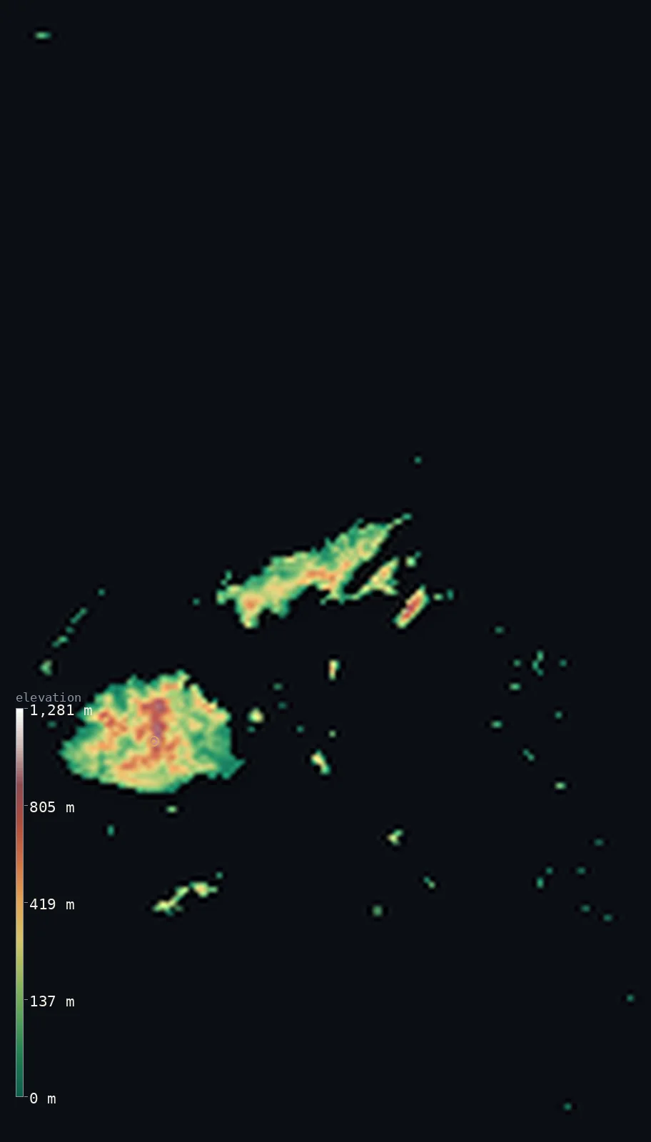
Fiji’s highest point is Mount Tomanivi (Mount Victoria) at 4,344 ft (1,324 m); its lowest is Pacific Ocean at 0 ft (0 m); the mean elevation is 669 ft (204 m).
Fiji is a volcanic archipelago of over 330 islands on a submerged Pacific platform — steep mountainous interiors on the big islands, low coral islets elsewhere. The two largest, Viti Levu and Vanua Levu, have rugged volcanic cores split by ranges above 900 m, culminating in Mount Tomanivi at 4,344 ft (1,324 m) on Viti Levu, an extinct volcano. Around and beyond them lie hundreds of smaller islands ringed by coral reefs, so most of the country is coast, hill and reef: half of Fiji lies below about 486 ft (148 m). Fiji straddles the 180° meridian, which runs through the island of Taveuni.
- Highest point📚
- 4,344 ft1,324 m
- Fiji's highest point is Mount Tomanivi (formerly Mount Victoria) at 4,344 ft (1,324 m), an extinct volcano in the rugged interior of Viti Levu, the largest island. Its central range divides Viti Levu into a wet southeast and a drier northwest, and the country's main rivers rise on its slopes.
- Lowest point📚
- 0 ft0 m
- Fiji's lowest point is sea level, along the coasts and coral reefs of its many islands — from the big volcanic islands' shores to the low coral islets of the Lau and Yasawa groups.
- Mean elevation⚙
- 669 ft204 m
- Computed from the GLO-30 model, Fiji's mean elevation is 669 ft (204 m) — for Fiji is a volcanic archipelago of steep mountainous interiors and low coral islets. Half the land lies below about 486 ft (148 m); the high ground is concentrated in the interiors of the two big islands, Viti Levu and Vanua Levu.
- Median elevation⚙
- 486 ft148 m
- Half of Fiji lies below about 486 ft (148 m) — the coastal plains and the many low coral islands. The high ground is the volcanic core of the larger islands, rising to Mount Tomanivi on Viti Levu.
- Elevation range📚
- 4,344 ft1,324 m
- From the sea to Mount Tomanivi at 1,324 m, Fiji's terrain spans about 4,344 ft — from coral shore up to the extinct volcano that crowns the interior of Viti Levu.
- Above 1,000 m (3,281 ft)⚙
- <1%
- <1% of Fiji rises above 1,000 m (3,281 ft) — only the highest interior ridges of Viti Levu around Mount Tomanivi. Most of the country is coast, hills and low coral islands.
- Official area📚
- 7,056 mi²18,274 km²
- Fiji covers about 7,056 sq mi (18,274 sq km) of land — a volcanic archipelago of over 330 islands on a submerged Pacific platform, the two largest (Viti Levu and Vanua Levu) holding most of the land and people.
- Forest cover📚
- 55.9%
- About 56% of Fiji is forested — dense rainforest on the wet windward slopes of the big islands, grassland and sugar-cane country on the dry leeward 'burning west', and coconut and reef on the smaller islands.
Highest and lowest points
Fiji's highest point is Mount Tomanivi, formerly Mount Victoria, at 4,344 ft (1,324 m) — an extinct volcano in the northern highlands of Viti Levu, the largest island. It is the crown of the central range that runs down the middle of Viti Levu, dividing the island into a wet, rainforested southeast and a drier northwest, and the country's main rivers rise on its slopes. Modest by world standards — close to the height of Ben Nevis in Scotland — it nonetheless dominates the interior of Fiji's main island. From its ridges the land falls away to the coastal plains and out to the hundreds of smaller islands of the archipelago.
source ↗Fiji's lowest ground is its coastline, at sea level, ringing over 330 islands with beaches, mangroves and coral reefs. From the shore the two big islands rise steeply into volcanic interiors. Viti Levu, the largest, has a jagged range down its middle culminating in Mount Tomanivi (1,324 m, the highest point), casting a rain shadow that makes the southeast wet rainforest and the northwest a dry 'burning west' of cane and grassland; its main rivers — the Rewa, Navua, Sigatoka and Ba — all rise around Tomanivi. Vanua Levu, the second island, is likewise split by a range above 900 m. Beyond the big islands lie the Lau, Lomaiviti and Yasawa groups and isolated Rotuma — a scatter of volcanic islets and low coral islands ringed by reefs, Fiji straddling the 180° meridian through Taveuni.
source ↗Fiji at a glance
Fiji straddles the 180-degree meridian - the International Date Line - which runs right through its island of Taveuni, so the country sits in both the Eastern and Western Hemispheres.
source ↗Fiji's highest point, Mount Tomanivi (1,324 m), is an extinct volcano - almost exactly the same height as Britain's Ben Nevis.
source ↗The central range of Viti Levu splits the island into a wet, rainforested southeast and a dry 'burning west' - so sugar cane grows on one side and dairy on the other.
source ↗Fiji is made up of over 330 islands and hundreds more islets, but only about a hundred are permanently inhabited; the two largest, Viti Levu and Vanua Levu, hold most of the land and people.
source ↗Almost all of Fiji's islands are volcanic in origin, rising from a submerged platform and ringed by coral reefs that make the Koro Sea hazardous to navigate.
source ↗Fiji's main rivers - the Rewa, Navua, Sigatoka and Ba - all rise in the mountains around Mount Tomanivi in the centre of Viti Levu.
source ↗
Elevation profile of Fiji
The largest share of land, 37%, falls in the 0–100 m band, and 91% of the territory lies below 500 m (1,640 ft).
- below 500 m (1,640 ft)91%
- 500–1,000 m9%
- 1,000–2,000 m<1%
Highest peaks of Fiji
| Peak | Elevation | Range | Note |
|---|---|---|---|
| Mount Tomanivi (Mount Victoria)↗ | 4,344 ft1,324 m | central range, Viti Levu | Highest point of Fiji, an extinct volcano in the interior of Viti Levu. |
| Koroyanitu (Mount Evans)↗ | 3,921 ft1,195 m | western Viti Levu | A high peak of the Mount Evans Range above the dry western coast near Lautoka. |
| Monavatu↗ | 3,707 ft1,130 m | central range, Viti Levu | Another summit of Viti Levu's mountainous volcanic interior. |
Fiji: Viti Levu's mountainous interior, Vanua Levu and the larger islands, and the coral islands and reefs
Viti Levu's mountainous interior
Viti Levu, the largest island, has a rugged volcanic core — a jagged range running north–south with several peaks above 900 m, culminating in Mount Tomanivi (1,324 m), the highest point. The range casts a strong rain shadow: the southeast is wet rainforest, the northwest a dry 'burning west' of cane and grassland, and the Rewa, Navua, Sigatoka and Ba rivers all rise here.
Vanua Levu and the larger islands
Vanua Levu, the second island, is likewise split along its length by a range above 900 m, with narrow coastal plains. Taveuni, Kadavu and the other larger islands are similarly volcanic and hilly, rising steeply from the sea and fringed by coral reefs.
The coral islands and reefs
Beyond the big islands lie hundreds of smaller ones — the Lomaiviti, Lau and Yasawa groups and isolated Rotuma — a mix of volcanic islets and low coral islands, all ringed by reefs. Fiji straddles the 180° meridian, which passes through Taveuni.
How to read this map
Color shows elevation; the raised relief shows real terrain. On this map Fiji reads as two big high islands among many low ones — the browns of the volcanic interiors of Viti Levu (highest at Mount Tomanivi) and Vanua Levu, dropping to green coastal plains, scattered among the low coral islets of the outer groups.
The 3D relief is the actual GLO-30 elevation data, exaggerated vertically so the mountainous interiors and the low coasts both show; the ×N relief slider controls how much. Tap anywhere to read that point's exact elevation.
City elevations in Fiji
Fiji's towns ring the coasts of the two big islands — Suva, the capital, on the wet southeast of Viti Levu; Lautoka, the sugar port, on the dry northwest; Labasa on Vanua Levu; and the old capital Levuka on the small island of Ovalau. Most Fijians live low, on the coast, below the volcanic interior.
| City | Population | Elevation |
|---|---|---|
| Suvacapitalthe capital, on the wet southeastern coast of Viti Levu, below the central range ↗ | 77,366 | 23 ft7 m |
| Lautokathe sugar port on the drier northwestern coast of Viti Levu ↗ | 52,500 | 131 ft40 m |
| Labasathe main town of Vanua Levu, Fiji's second-largest island ↗ | 27,949 | 13 ft4 m |
| Levukathe old colonial capital, on the small volcanic island of Ovalau ↗ | 8,360 | 187 ft57 m |
| Vaileka | 5,964 | 26 ft8 m |
| Ahau | 0 | 148 ft45 m |
| Tubou | 0 | 16 ft5 m |
Elevation sampled at each city centre from the Copernicus GLO-30 model. Cities and population from GeoNames (CC-BY 4.0).
Fiji in comparison
Fiji's terrain rises 4,344 ft (1,324 m) from sea level to Mount Tomanivi (Mount Victoria) — about 15% of the height of Mount Everest, the world's highest point at 29,032 ft (8,849 m).
- Vanuatu's mean elevation is 899 ft — 230 ft higher; its high point, Mount Tabwemasana, reaches 6,165 ft (1,879 m), 1,821 ft above. Vanuatu elevation map →
- Samoa's mean elevation is 1,217 ft — 548 ft higher; its high point, Mount Silisili, reaches 6,096 ft (1,858 m), 1,752 ft above. Samoa elevation map →
- Tonga's mean elevation is 176 ft — 493 ft lower; its high point, Kao, reaches 3,389 ft (1,033 m), 955 ft below. Tonga elevation map →
Frequently asked questions
What is the highest point in Fiji?
- Mount Tomanivi (formerly Mount Victoria), 4,344 ft (1,324 m), an extinct volcano in the interior of Viti Levu.
What is the average elevation of Fiji?
- Fiji is a volcanic archipelago of steep islands and low coral islets, so no single published figure represents it well; this page reports the area-weighted mean of 669 ft (204 m) computed from the Copernicus GLO-30 model.
What is the lowest point in Fiji?
- Sea level, along the coasts and coral reefs of its islands.
What are Fiji's main islands?
- Viti Levu (the largest, with Suva and Mount Tomanivi) and Vanua Levu, plus Taveuni, Kadavu and the Lau, Lomaiviti and Yasawa groups, among over 330 islands.
Does the International Date Line run through Fiji?
- Yes - Fiji straddles the 180-degree meridian, which passes through the island of Taveuni, putting the country in both hemispheres (the legal date line detours around it).
Are Fiji's islands volcanic?
- Mostly yes - the islands rise from a submerged volcanic platform; the larger ones are mountainous and volcanic, while many smaller ones are low coral islands ringed by reefs.
How tall is Mount Tomanivi compared to other mountains?
- At 1,324 m it is modest by world standards - close to the height of Ben Nevis in Scotland - but it is the highest in Fiji and dominates the interior of Viti Levu.
Is this a topographic, relief, contour, or elevation map of Fiji?
- They describe the same thing - terrain height. This page renders Fiji's actual elevation surface in interactive 3D (a relief or topographic view) and reports the elevation statistics computed from it; a contour map shows the same data as lines of equal height.
About this map
The terrain is rendered from the Copernicus GLO-30 digital elevation model (ESA), masked to the FJI-ADM0 boundary from geoBoundaries (gbOpen). Elevation statistics are computed directly from the model; peak names and researched facts are sourced and cited. See the methodology for the full pipeline.
Our area-weighted mean, computed from the Copernicus GLO-30 model, is 669 ft (204 m); no authority publishes a mean elevation (no authoritative published mean). Fiji is a volcanic archipelago of over 330 islands, and its height is gathered in a few big ones. The two largest — Viti Levu and Vanua Levu — have rugged, rainforested volcanic interiors, split down the middle by ranges rising above 900 m, culminating in Mount Tomanivi (1,324 m) on Viti Levu. Around and beyond them lie hundreds of smaller volcanic and low coral islands, so most of the country is coast, hill and reef: half of Fiji lies below about 486 ft (148 m). No single published mean represents so mixed an archipelago; the figure here is computed from the GLO-30 model.
Surveyed national figures: official area · forest cover · high point.
Rendered from Copernicus GLO-30 (ESA, 2021 release), boundaries from geoBoundaries. Generated 2026-07-25.