Vanuatu Elevation Map — Topographic & 3D Terrain
Explore the terrain of Vanuatu in interactive 3D, built from Copernicus GLO-30 satellite elevation data — a chain of volcanic islands strung down the southwestern Pacific. Drag to rotate, scroll to zoom, and tap any point to read its elevation.
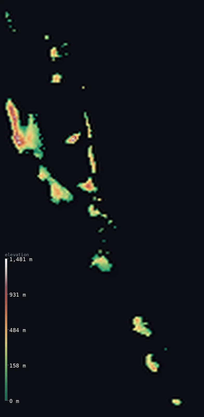
Vanuatu’s highest point is Mount Tabwemasana at 6,165 ft (1,879 m); its lowest is Pacific Ocean at 0 ft (0 m); the mean elevation is 899 ft (274 m).
Vanuatu is a Y-shaped scatter of about 80 islands running more than 1,000 km down the southwestern Pacific, and almost every one of them is volcanic. The islands rise steeply from the sea to forested interiors — more than half the country's land stands above 656 ft (200 m) — and several hold active volcanoes. The highest ground is Mount Tabwemasana at 6,165 ft (1,879 m), on the largest island, Espiritu Santo, in the north.
- Highest point📚
- 6,165 ft1,879 m
- Vanuatu's highest point is Mount Tabwemasana at 6,165 ft (1,879 m), on Espiritu Santo — the largest island in the country, whose rugged, forested interior rises far higher than anywhere else in the archipelago.
- Lowest point📚
- 0 ft0 m
- Vanuatu's lowest point is the Pacific at sea level, around the shores of some 80 islands — a coastline of reef, black volcanic sand, and raised coral terraces lifted by the islands' restless geology.
- Mean elevation⚙
- 899 ft274 m
- Vanuatu's mean elevation computed from the GLO-30 model is 899 ft (274 m) — high for an island nation, reflecting terrain that rises steeply from the coast: these are volcanic islands with mountainous interiors, not low coral atolls.
- Median elevation⚙
- 679 ft207 m
- Half of Vanuatu lies below 679 ft (207 m) — a little below the mean, the balance of a country whose islands climb quickly from the shore, with steep interior high ground set against the coastal lowlands where most people live.
- Elevation range📚
- 6,165 ft1,879 m
- From the sea to the summit of Mount Tabwemasana, Vanuatu spans about 6,160 ft — most of it gained on Espiritu Santo, whose interior rises far above the lower islands strung out to the south.
- Above 1,000 m (3,281 ft)⚙
- 2%
- About 2% of Vanuatu rises above 1,000 m (3,281 ft) — a small share, essentially the mountainous interior of Espiritu Santo, where Tabwemasana and its neighbouring ridges stand. Most of the archipelago is lower, steep coastal and hill country.
- Official area📚
- 4,706 mi²12,189 km²
- Vanuatu covers about 4,700 sq mi (12,189 sq km) of land spread across some 80 islands over more than 1,000 km of ocean — a small land area scattered across a vast stretch of the southwestern Pacific.
- Forest cover📚
- 36.3%
- About 36.3% of Vanuatu is forested — dense tropical rainforest cloaking the steep volcanic interiors of the larger islands, thinning only where cultivation and the coast take over.
Highest and lowest points
Vanuatu's highest point is Mount Tabwemasana, 6,165 ft (1,879 m), in the rugged interior of Espiritu Santo, the largest island in the country. Its steep, rainforested slopes rise far above the rest of the archipelago — most of Vanuatu's islands are much lower — and its remote interior is among the least accessible terrain in the country. Vanuatu is intensely volcanic, with active cones such as Yasur on Tanna and Lopevi elsewhere in the chain, though Tabwemasana itself is the high point rather than an active vent.
source ↗Vanuatu's lowest point is the Pacific at sea level, around the shores of roughly 80 islands. The coastline reflects the islands' volcanic and tectonic origins: black-sand beaches, fringing coral reef, and raised terraces where the land has been lifted out of the sea by the same active geology that builds the volcanoes. Vanuatu sits on the Pacific Ring of Fire, and the ground here rises and falls with earthquakes as readily as it does with the tide.
source ↗Vanuatu at a glance
Vanuatu's highest point, Mount Tabwemasana (1,879 m), rises on Espiritu Santo, the largest and most mountainous of the country's roughly 80 islands.
source ↗Vanuatu is a chain of about 80 volcanic islands running more than 1,000 km down the southwestern Pacific.
source ↗Vanuatu sits on the Pacific Ring of Fire and has several active volcanoes, including Mount Yasur on Tanna, one of the most accessible active volcanoes in the world.
source ↗The islands rise steeply from the sea to forested interiors - more than half of Vanuatu's land stands above 200 m, unusually high for a Pacific island nation.
source ↗Vanuatu's active geology lifts its coastlines out of the sea over time, leaving raised coral terraces around many of the islands.
source ↗Vanuatu is one of the most exposed countries on Earth to natural hazards - cyclones, earthquakes, and volcanic eruptions all recur across the archipelago.
source ↗Its highest point, Tabwemasana, is so remote that fewer than about six people reach its summit in a typical year.
source ↗A tree species found nowhere else on Earth, Metrosideros tabwemasanaensis, grows only on Mount Tabwemasana.
source ↗
Elevation profile of Vanuatu
The largest share of land, 25%, falls in the 0–100 m band, and 86% of the territory lies below 500 m (1,640 ft).
- below 500 m (1,640 ft)86%
- 500–1,000 m12%
- 1,000–2,000 m2%
Highest peaks of Vanuatu
| Peak | Elevation | Range | Note |
|---|---|---|---|
| Mount Tabwemasana↗ | 6,165 ft1,879 m | Santo Mountain Chain (Espiritu Santo) | Highest point of Vanuatu, on the west of Espiritu Santo - an ultra-prominent peak of the island's volcanic spine. |
| Mount Yasur↗ | 1,184 ft361 m | Tanna (active volcano) | A low but world-famous active volcano on the southern island of Tanna, with a near-permanently glowing crater. |
North to south down a volcanic chain
Espiritu Santo and the northern islands
The north holds the country's largest and highest island, Espiritu Santo, whose mountainous, rainforested interior rises to Mount Tabwemasana — far above anything else in Vanuatu — along with other substantial islands like Malekula. This is the country's high ground.
The central islands
The middle of the chain holds Éfate, the island carrying the capital, Port-Vila, and most of the country's people and infrastructure, along with the Shepherd Islands — volcanic, hilly, and lower than the northern peaks.
The southern islands and the volcanoes
The southern arm of the Y runs down to Tanna, Erromango, and Aneityum — volcanic islands including Tanna's Mount Yasur, an active cone that has been erupting continuously for centuries and draws visitors to its rim.
How to read this map
Color shows elevation; the raised relief shows real terrain. On this map Vanuatu reads as a scattered Y of green volcanic islands, steep and forested, with the highest brown ground concentrated on Espiritu Santo in the north.
The 3D relief is the actual GLO-30 elevation data, exaggerated vertically so the islands' steep rise from the sea shows; because the peaks are sharp and the islands widely spaced, the very highest summits read a little lower than their surveyed height — the figures on this page use the surveyed elevations. Tap anywhere to read that point's exact elevation.
City elevations in Vanuatu
Vanuatu's towns are coastal - Port-Vila on Éfate and Luganville on Espiritu Santo are the two main centres, both at sea level on their islands' shores. The mountainous interiors are sparsely settled.
| City | Population | Elevation |
|---|---|---|
| Port-Vilacapitalthe capital, on the south coast of Éfate at sea level, the country's main town and port ↗ | 35,901 | 46 ft14 m |
| Luganvilleon Espiritu Santo, the second town, beneath the island's mountainous interior ↗ | 13,397 | 23 ft7 m |
| Norsup | 2,998 | 56 ft17 m |
| Isangel | 1,437 | 331 ft101 m |
| Sola | 1,171 | 49 ft15 m |
| Saratamata | 0 | 30 ft9 m |
Elevation sampled at each city centre from the Copernicus GLO-30 model. Cities and population from GeoNames (CC-BY 4.0).
Vanuatu in comparison
Vanuatu's terrain rises 6,165 ft (1,879 m) from sea level to Mount Tabwemasana — about 21% of the height of Mount Everest, the world's highest point at 29,032 ft (8,849 m).
- Fiji's mean elevation is 669 ft — 230 ft lower; its high point, Mount Tomanivi (Mount Victoria), reaches 4,344 ft (1,324 m), 1,821 ft below. Fiji elevation map →
- Solomon Islands's mean elevation is 1,358 ft — 459 ft higher; its high point, Mount Popomanaseu, reaches 7,661 ft (2,335 m), 1,496 ft above. Solomon Islands elevation map →
Frequently asked questions
What is the highest point in Vanuatu?
- Mount Tabwemasana, 6,165 ft (1,879 m), in the mountainous interior of Espiritu Santo, the country's largest island.
What is the lowest point in Vanuatu?
- Sea level, around the shores of the country's roughly 80 islands.
What is the average elevation of Vanuatu?
- Computed from the Copernicus GLO-30 model, the area-weighted mean is 899 ft (274 m) - high for an island nation, because these are steep volcanic islands rather than low coral atolls.
Is Vanuatu volcanic?
- Yes - the islands sit on the Pacific Ring of Fire, with several active volcanoes, including Mount Yasur on Tanna, one of the most accessible active volcanoes in the world.
How many islands make up Vanuatu?
- About 80, strung in a Y-shape over more than 1,000 km of the southwestern Pacific, of which around 65 are inhabited.
Is this a topographic, relief, contour, or elevation map of Vanuatu?
- They describe the same thing - terrain height. This page renders the country's actual elevation surface in interactive 3D and reports the statistics computed from it.
About this map
The terrain is rendered from the Copernicus GLO-30 digital elevation model (ESA), masked to the VUT-ADM0 boundary from geoBoundaries (gbOpen). Elevation statistics are computed directly from the model; peak names and researched facts are sourced and cited. See the methodology for the full pipeline.
Our area-weighted mean, computed from the Copernicus GLO-30 model, is 899 ft (274 m); no authority publishes a mean elevation (No authoritative published mean elevation). No standard source publishes a single mean elevation for Vanuatu, a scattered chain of mountainous volcanic islands. The page reports the area-weighted mean computed from the Copernicus GLO-30 model over the islands.
Surveyed national figures: official area · forest cover · high point.
Rendered from Copernicus GLO-30 (ESA, 2021 release), boundaries from geoBoundaries. Generated 2026-07-25.