Solomon Islands Elevation Map
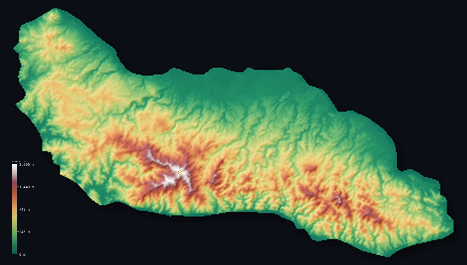
Solomon Islands’s highest point is Mount Popomanaseu at 7,661 ft (2,335 m); its lowest is Pacific Ocean at 0 ft (0 m); the mean elevation is 1,358 ft (414 m).
- Highest point📚
- 7,661 ft2,335 m
- Mount Popomanaseu, in the interior of Guadalcanal.
- Lowest point📚
- 0 ft0 m
- Sea level around the islands.
- Mean elevation⚙
- 1,358 ft414 m
- Computed from the GLO-30 surface model across the rendered land.
- Median elevation⚙
- 1,063 ft324 m
- Half of Solomon Islands lies below this height.
- Elevation range📚
- 7,661 ft2,335 m
- From the sea to Mount Popomanaseu at about 2,335 m.
- Above 1,000 m (3,281 ft)⚙
- 8%
- The mountainous interiors of the larger islands.
- Official area📚
- 11,157 mi²28,896 km²
- A double chain of mountainous islands in the southwest Pacific.
- Forest cover📚
- 77.9%
- Heavily forested - dense rainforest across the larger islands.
Highest and lowest points
The highest point of Solomon Islands, Mount Popomanaseu, a volcanic summit in the rugged interior of Guadalcanal, the country's largest island. At about 2,335 m (some sources give 2,330-2,332 m) it is the highest peak in the insular South Pacific east of New Guinea. Survey data confirms it - not the nearby Mount Makarakomburu - as the true high point. It is an island interior summit, not on a border.
source ↗Solomon Islands at a glance
Mount Popomanaseu (about 2,335 m) is the highest peak in the island Pacific east of New Guinea - nothing higher stands between it and the Andes.
source ↗Survey data settled a long dispute, confirming Popomanaseu - not nearby Makarakomburu - as the true high point.
source ↗The main islands form two parallel chains that converge on Makira in the southeast.
source ↗The country's islands span about 1,500 km from west to east, with the Santa Cruz group isolated far to the southeast.
source ↗Bougainville, the largest island of the Solomons archipelago, belongs politically to Papua New Guinea, not to Solomon Islands.
source ↗
Elevation profile of Solomon Islands
The largest share of land, 37%, falls in the 0–200 m band, and 66% of the territory lies below 500 m (1,640 ft).
- below 500 m (1,640 ft)66%
- 500–1,000 m26%
- 1,000–2,000 m8%
- above 2,000 m (6,562 ft)<1%
Highest peaks of Solomon Islands
Terrain regions of Solomon Islands
Mount Popomanaseu (about 2,335 m) is the highest peak in the island Pacific east of New Guinea - nothing higher stands between it and the Andes. ↗
Guadalcanal and the high islands
↗The mountainous heart of the country - Guadalcanal, the largest island, with the rainforested Kavo Range rising to Mount Popomanaseu, plus the other large volcanic islands of the double chain.
The double island chain
↗The main islands lie in two parallel chains running northwest to southeast - the southern (New Georgia, Savo, Guadalcanal) and the northern (Choiseul, Santa Isabel, Malaita) - converging on Makira in the southeast.
The outer islands and atolls
↗Scattered far beyond the main chains are low coral atolls and remote volcanic outliers - the Santa Cruz Islands more than 600 km to the southeast, and atolls like Rennell, Bellona and Ontong Java.
Guadalcanal
the largest islandThe largest island, about 5,300 km2, is dominated by a rugged, rainforested interior. The Kavo Range runs along its spine and rises to Mount Popomanaseu (about 2,335 m) and the neighbouring Makarakomburu, the two highest points in the country. Narrow coastal plains fringe the island, with the capital Honiara on the north coast and the steep 'Weather Coast' to the south.
The other large islands
the rest of the main chainThe remaining main islands - Malaita, Santa Isabel, Choiseul, the New Georgia group, Makira and others - are also mountainous and forested, though lower than Guadalcanal, with rugged interiors, fringing reefs and lagoons. They lie in two parallel chains formed along the Pacific Ring of Fire, some with active or recently active volcanoes such as Kolombangara and Savo.
The outer islands
the far-flung remainderFar from the main chains lie scattered outliers - the volcanic and coral Santa Cruz Islands over 600 km to the southeast, and isolated atolls such as Rennell, Bellona, Ontong Java and the tiny outliers Tikopia and Anuta. These are mostly low, rising only a little above the sea.
City elevations in Solomon Islands
| City | Population | Elevation |
|---|---|---|
| HoniaracapitalHoniara, the capital, sits on the north coast of Guadalcanal below the mountainous interior that rises to Mount Popomanaseu. ↗ | 56,298 | 148 ft45 m |
| Malango | 10,532 | 82 ft25 m |
Elevation sampled at each city centre from the Copernicus GLO-30 model. Cities and population from GeoNames (CC-BY 4.0).
Solomon Islands in comparison
Solomon Islands's terrain rises 7,661 ft (2,335 m) from sea level to Mount Popomanaseu — about 26% of the height of Mount Everest, the world's highest point at 29,032 ft (8,849 m).
- Vanuatu's mean elevation is 899 ft — 459 ft lower; its high point, Mount Tabwemasana, reaches 6,165 ft (1,879 m), 1,496 ft below. Vanuatu elevation map →
- Papua New Guinea's mean elevation is 2,113 ft — 755 ft higher; its high point, Mount Wilhelm, reaches 14,793 ft (4,509 m), 7,133 ft above. Papua New Guinea elevation map →
- Fiji's mean elevation is 669 ft — 689 ft lower; its high point, Mount Tomanivi (Mount Victoria), reaches 4,344 ft (1,324 m), 3,317 ft below. Fiji elevation map →
Frequently asked questions
What is the highest point in Solomon Islands?
- Mount Popomanaseu, about 7,661 ft (2,335 m), a volcano in the interior of Guadalcanal, the largest island.
What is the average elevation of Solomon Islands?
- No standard source publishes one, so this page reports the mean computed from the Copernicus GLO-30 model, 1,358 ft (414 m), over the rendered land.
What is the lowest point in Solomon Islands?
- Sea level, around the coasts and reefs of its many islands.
Is Popomanaseu or Makarakomburu the highest?
- Popomanaseu. Some older sources claimed Makarakomburu (about 2,310 m) was higher, but survey data confirms Popomanaseu as the country's high point.
How spread out are the Solomon Islands?
- The islands stretch about 1,500 km from west to east, with the Santa Cruz group isolated more than 600 km from the main chain.
Is this a topographic, relief, contour, or elevation map of Solomon Islands?
- They describe the same thing - terrain height. This page renders the country's actual elevation surface in interactive 3D (a relief or topographic view) and reports the elevation statistics computed from it; a contour map shows the same data as lines of equal height.
About this map
The terrain is rendered from the Copernicus GLO-30 digital elevation model (ESA), masked to the SLB-ADM0 boundary from geoBoundaries (gbOpen). Elevation statistics are computed directly from the model; peak names and researched facts are sourced and cited. See the methodology for the full pipeline.
Our area-weighted mean, computed from the Copernicus GLO-30 model, is 1,358 ft (414 m); no authority publishes a mean elevation (No authoritative published mean elevation). No standard source publishes a single mean elevation for Solomon Islands; the larger islands have mountainous, rainforested interiors rising over 2,000 m, while many smaller islands and atolls are low. The page reports the area-weighted mean computed from the Copernicus GLO-30 model over the rendered land.
Surveyed national figures: official area · forest cover · high point.
Rendered from Copernicus GLO-30 (ESA, 2021 release), boundaries from geoBoundaries. Generated 2026-06-26.