Papua New Guinea Elevation Map — Topographic & 3D Terrain
Explore the terrain of Papua New Guinea in interactive 3D, built from Copernicus GLO-30 satellite elevation data — a rugged Highlands spine and vast lowland river swamps on the eastern half of New Guinea. Drag to rotate, scroll to zoom, and tap any point to read its elevation.
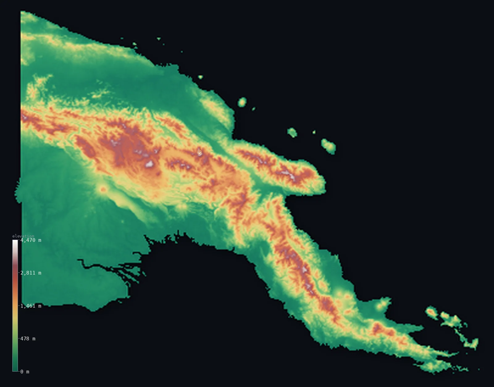
Papua New Guinea’s highest point is Mount Wilhelm at 14,793 ft (4,509 m); its lowest is Pacific Ocean at 0 ft (0 m); the mean elevation is 2,113 ft (644 m).
Papua New Guinea occupies the eastern half of the great island of New Guinea, and it is at once one of the most mountainous and one of the swampiest countries on Earth. A rugged Highlands spine — the New Guinea Highlands, or Central Range — runs the length of the mainland, rising to Mount Wilhelm at 14,793 ft (4,509 m), the highest peak in Oceania by political boundaries, its equatorial summit occasionally dusted with snow. North and south of it spread vast lowland river basins — the Sepik and the Fly, among the largest freshwater swamplands on Earth — so half the country lies below about 646 ft (197 m). Some 600 islands, about 15% of the land, lie offshore; this map centres on the New Guinea mainland.
- Highest point📚
- 14,793 ft4,509 m
- Papua New Guinea's highest point is Mount Wilhelm at 14,793 ft (4,509 m), in the Bismarck Range of the central Highlands — the highest peak in Oceania by political boundaries. (The island of New Guinea has a higher summit, Puncak Jaya at 4,884 m, but it lies across the border in Indonesian Papua.) Its summit, just south of the equator, can receive snow.
- Lowest point📚
- 0 ft0 m
- Papua New Guinea's lowest point is sea level, along its long coastline and the great deltas of the Fly and Sepik rivers — among the largest freshwater swamplands on Earth. From these lowlands the land climbs steeply into the Highlands.
- Mean elevation⚙
- 2,113 ft644 m
- Computed from the GLO-30 model, Papua New Guinea's mean elevation is 2,113 ft (644 m) — a moderate figure that hides two extremes, for PNG is at once one of the most mountainous and one of the swampiest countries on Earth. A rugged Highlands spine, rising to Mount Wilhelm, lifts the average; but half the country lies below about 646 ft (197 m), in the vast lowland river basins of the Sepik and the Fly.
- Median elevation⚙
- 646 ft197 m
- Half of Papua New Guinea lies below about 646 ft (197 m) — the great lowland floodplains and swamps of the Sepik and Fly rivers, and the coastal plains, cover a huge share of the country. The high ground is the Highlands spine and the mountainous islands, which lift the mean well above this typical low.
- Elevation range📚
- 14,793 ft4,509 m
- From the sea to the summit of Mount Wilhelm at 4,509 m, Papua New Guinea's terrain spans about 14,793 ft — from equatorial swamp and coast up to a snow-dusted peak, the roof of Oceania within its recognized borders.
- Above 1,000 m (3,281 ft)⚙
- 26%
- About 26% of Papua New Guinea rises above 1,000 m (3,281 ft) — the broad Highlands spine that runs the length of the mainland, holding the populous highland valleys, and the mountainous interiors of the larger islands. The lowland river basins and coasts lie below.
- Above 2,000 m (6,562 ft)⚙
- 10%
- Roughly 10% of Papua New Guinea stands above 2,000 m (6,562 ft) — the high Highlands ranges, the Bismarck (with Mount Wilhelm), the Southern Highlands (with Mount Giluwe) and the Owen Stanley, where the highest valleys and peaks lie.
- Official area📚
- 178,703 mi²462,840 km²
- Papua New Guinea covers about 178,703 sq mi (462,840 sq km) — the eastern half of the great island of New Guinea, plus some 600 offshore islands, a rugged, heavily forested country of Highlands, lowland swamp and volcanic islands on the Pacific Ring of Fire.
- Forest cover📚
- 74.1%
- About 74% of Papua New Guinea is forested — dense tropical rainforest from the coastal swamps up into the montane cloud forest of the Highlands, among the most extensively forested countries in the world.
Highest and lowest points
Papua New Guinea's highest point is Mount Wilhelm, 14,793 ft (4,509 m), a rugged peak in the Bismarck Range of the central Highlands, where the Chimbu, Jiwaka and Madang provinces meet, deep in the interior far from any border. It is the highest peak in Oceania by political boundaries: the island of New Guinea has a higher summit, Puncak Jaya (4,884 m), but that lies across the 141° E border in Indonesian Papua, so Mount Wilhelm is the high point of Papua New Guinea and, among the countries of Oceania, of the region. Its bare summit, just south of the equator, can catch snow. Wilhelm crowns the great Highlands spine — with Mount Giluwe (4,367 m), an extinct shield volcano and the highest volcano in Oceania, and the Owen Stanley Range to the southeast — that runs the length of the mainland above the vast lowland swamps of the Sepik and the Fly.
source ↗Papua New Guinea's lowest ground is its coastline, at sea level, and the great river deltas that fringe it. North and south of the central mountains spread vast lowland river basins: the Sepik winds 1,126 km through swamps to the north coast, and the Fly drains one of the largest freshwater swamplands on Earth to the Gulf of Papua in the south — among the biggest wetlands anywhere. These low lands, with the coastal plains, cover the greatest share of the country. Above them rises the country's defining feature: the New Guinea Highlands, a broad belt of rugged mountains running the length of the mainland, climbing to Mount Wilhelm (4,509 m, the highest point) in the Bismarck Range and Mount Giluwe (4,367 m) in the Southern Highlands, with the Owen Stanley Range carrying the spine into the southeastern tail. A second chain, the Finisterre and Saruwaged ranges, fringes the north coast on the Huon Peninsula. Around the mainland lie some 600 islands — the mountainous Bismarck Archipelago (New Britain, New Ireland), the Admiralty Islands and volcanic Bougainville, about 15% of the land — but this map centres on the New Guinea mainland; the larger islands lie across open sea, beyond the area shown here.
source ↗Papua New Guinea at a glance
Mount Wilhelm (4,509 m) is the highest point in Papua New Guinea, and its summit - just south of the equator - can receive snow.
source ↗By political boundaries Mount Wilhelm is the highest peak in Oceania, though New Guinea's Puncak Jaya (in Indonesia) is taller.
source ↗Mountains cover well over half the country, and a single Highlands spine runs almost its entire length.
source ↗The Fly and Sepik rivers wind through some of the largest freshwater swamplands on Earth.
source ↗Papua New Guinea is one of the most rugged and forested countries in the world, and the most linguistically diverse, with over 800 languages.
source ↗About 600 islands make up roughly 15% of the land, many of them mountainous and volcanic along the Ring of Fire.
source ↗
Elevation profile of Papua New Guinea
The largest share of land, 62%, falls in the 0–500 m band, and 62% of the territory lies below 500 m (1,640 ft).
- below 500 m (1,640 ft)62%
- 500–1,000 m12%
- 1,000–2,000 m17%
- above 2,000 m (6,562 ft)10%
Highest peaks of Papua New Guinea
| Peak | Elevation | Range | Note |
|---|---|---|---|
| Mount Wilhelm↗ | 14,793 ft4,509 m | Bismarck Range (central Highlands) | Highest point of Papua New Guinea, a rugged peak in the Bismarck Range. |
| Mount Giluwe↗ | 14,327 ft4,367 m | Southern Highlands | An extinct shield volcano, the second-highest peak in PNG and the highest volcano in Oceania. |
| Boising↗ | 13,615 ft4,150 m | Saruwaged Range (Huon Peninsula) | The most topographically prominent peak in PNG, on the northern Huon Peninsula. |
| Mount Bangeta↗ | 13,520 ft4,121 m | Saruwaged Range (Huon Peninsula) | A high summit of the Saruwaged Range on the north coast peninsula. |
| Mount Victoria↗ | 13,248 ft4,038 m | Owen Stanley Range (southeast) | The high point of the Owen Stanley Range in the southeastern tail of the mainland. |
Papua New Guinea: the Highlands spine, the lowland basins and coasts, and the islands
The Highlands spine
A broad belt of rugged mountains — the New Guinea Highlands, or Central Range — runs the length of the mainland, rising to Mount Wilhelm (4,509 m, the high point) in the Bismarck Range and Mount Giluwe (4,367 m, the highest volcano in Oceania) in the Southern Highlands, with the Owen Stanley Range carrying it into the southeastern tail. Deep highland valleys between the ranges hold much of the population; the highest summits occasionally see snow.
The lowland basins and coasts
North and south of the Highlands lie great lowland river basins. The Sepik winds 1,126 km through swamps to the north coast, and the Fly drains one of the largest swamplands on Earth to the Gulf of Papua in the south. A second mountain chain — the Finisterre and Saruwaged ranges of the Huon Peninsula — fringes the north coast.
The islands
Around the mainland lie some 600 islands, about 15% of the country's land — the mountainous Bismarck Archipelago (New Britain, New Ireland), the Admiralty Islands (Manus) and volcanic Bougainville, strung along the Pacific Ring of Fire with active volcanoes near Rabaul. This map centres on the New Guinea mainland; the larger islands lie across open sea, beyond the main view.
How to read this map
Color shows elevation; the raised relief shows real terrain. On this map Papua New Guinea reads as a high spine above vast low basins — the browns and whites of the Highlands running the length of the mainland (highest at Mount Wilhelm), dropping to the deep green lowland swamps of the Sepik in the north and the Fly in the south, with a second range along the north coast (the Huon Peninsula).
The 3D relief is the actual GLO-30 elevation data, exaggerated vertically so the high Highlands and the low river basins both show; the ×N relief slider controls how much. Tap anywhere to read that point's exact elevation. (The map centres on the New Guinea mainland; the offshore islands — New Britain, New Ireland, Bougainville — lie beyond the main view.)
City elevations in Papua New Guinea
Papua New Guinea's cities split between the coast and the Highlands — Port Moresby, the capital, on the south coast, and Lae, the second city, on the north coast below the mountains, with Madang and Wewak along the northern shore, and Mount Hagen and Goroka high in the populous Highlands valleys. Much of the population lives in the interior mountains.
| City | Population | Elevation |
|---|---|---|
| Port Moresbycapitalthe capital, on the south coast of the mainland, on the Gulf of Papua ↗ | 283,733 | 66 ft20 m |
| Laethe second city, on the north coast at the mouth of the Markham River below the Highlands ↗ | 76,255 | 121 ft37 m |
| Mount Hagena Highlands town in the Wahgi Valley, one of the largest in the interior ↗ | 33,623 | 5,659 ft1,725 m |
| Popondetta | 28,198 | 344 ft105 m |
| Madanga port on the north coast, below the Finisterre Range ↗ | 27,419 | 16 ft5 m |
| Gorokaa Highlands town in the Eastern Highlands, in a fertile upland valley ↗ | 18,503 | 5,164 ft1,574 m |
| Wewak | 18,230 | 115 ft35 m |
| Daru | 15,214 | 23 ft7 m |
| Kiunga | 11,536 | 131 ft40 m |
| Vanimo | 11,204 | 13 ft4 m |
Elevation sampled at each city centre from the Copernicus GLO-30 model. Cities and population from GeoNames (CC-BY 4.0).
Papua New Guinea in comparison
Papua New Guinea's terrain rises 14,793 ft (4,509 m) from sea level to Mount Wilhelm — about 51% of the height of Mount Everest, the world's highest point at 29,032 ft (8,849 m).
- Indonesia's mean elevation is 1,112 ft — 1,001 ft lower; its high point, Puncak Jaya (Carstensz Pyramid), reaches 16,024 ft (4,884 m), 1,230 ft above. Indonesia elevation map →
- Solomon Islands's mean elevation is 1,358 ft — 755 ft lower; its high point, Mount Popomanaseu, reaches 7,661 ft (2,335 m), 7,133 ft below. Solomon Islands elevation map →
- Australia's mean elevation is 902 ft — 1,211 ft lower; its high point, Mount Kosciuszko, reaches 7,310 ft (2,228 m), 7,484 ft below. Australia elevation map →
Frequently asked questions
What is the highest point in Papua New Guinea?
- Mount Wilhelm, 14,793 ft (4,509 m), in the Bismarck Range of the central Highlands - the highest peak in Oceania by political boundaries.
What is the average elevation of Papua New Guinea?
- Computed from the Copernicus GLO-30 model, the area-weighted mean is 2,113 ft (644 m). The country is largely mountainous with broad lowland river basins.
What is the lowest point in Papua New Guinea?
- Sea level, along its long coastline and the deltas of the Fly and Sepik rivers.
Is Mount Wilhelm the highest mountain on New Guinea?
- No - the island's highest peak is Puncak Jaya (4,884 m), but it lies in Indonesian Papua. Mount Wilhelm is the highest within Papua New Guinea.
Does this map include the islands?
- It centres on the New Guinea mainland, which holds most of the land and the high point. The larger offshore islands - New Britain, New Ireland, Bougainville - lie across open sea from the mainland.
Is this a topographic, relief, contour, or elevation map of Papua New Guinea?
- They describe the same thing - terrain height. This page renders Papua New Guinea's actual elevation surface in interactive 3D (a relief or topographic view) and reports the elevation statistics computed from it; a contour map shows the same data as lines of equal height.
About this map
The terrain is rendered from the Copernicus GLO-30 digital elevation model (ESA), masked to the PNG-ADM0 boundary from geoBoundaries (gbOpen). Elevation statistics are computed directly from the model; peak names and researched facts are sourced and cited. See the methodology for the full pipeline.
Our area-weighted mean, computed from the Copernicus GLO-30 model, is 2,113 ft (644 m); the figure commonly cited elsewhere is 2,188 ft (667 m) (CIA World Factbook). Papua New Guinea is at once one of the most mountainous and one of the swampiest countries on Earth. A rugged Highlands spine — the New Guinea Highlands, or Central Range — runs the length of the mainland, rising to Mount Wilhelm (4,509 m), the highest point in Oceania by political boundaries, snow occasionally dusting its equatorial summit. But north and south of the Highlands spread vast lowland river basins — the Sepik and the Fly, draining some of the largest freshwater swamplands on Earth — and it is these low lands, with the coastal plains, that cover the greatest share of the country. So half of Papua New Guinea lies below about 646 ft (197 m), even as its mountains lift the average far higher. Around the mainland lie some 600 islands, about 15% of the land — the mountainous Bismarck Archipelago (New Britain, New Ireland), the Admiralty Islands (Manus) and volcanic Bougainville — but this map centres on the New Guinea mainland, which holds the bulk of the land and the high point; the larger islands lie across open sea, beyond the main view.
Surveyed national figures: official area · forest cover · high point.
Rendered from Copernicus GLO-30 (ESA, 2021 release), boundaries from geoBoundaries. Generated 2026-06-26.
Bordering countries · 1
Papua New Guinea shares a land border with these countries — open any one to compare its terrain and highest point.