Australia Elevation Map — Topographic & 3D Terrain
Explore the terrain of Australia in interactive 3D, built from Copernicus GLO-30 satellite elevation data — the flattest and oldest of the inhabited continents. Drag to rotate, scroll to zoom, and tap any point to read its elevation.
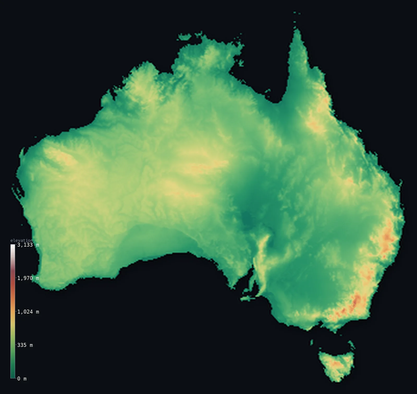
Australia’s highest point is Mount Kosciuszko at 7,310 ft (2,228 m); its lowest is Lake Eyre (Kati Thanda) at −49 ft (−15 m); the mean elevation is 902 ft (275 m).
Australia is the flattest, lowest, and oldest of the inhabited continents. Nearly nine-tenths of it lies below 500 m (1,640 ft) — a vast, worn interior of plains and low plateau, ground down over hundreds of millions of years. Its highest point, Mount Kosciuszko, reaches only 7,310 ft (2,228 m) on the mainland, and it is the lowest continental summit on Earth.
- Highest point📚
- 7,310 ft2,228 m
- The highest point on mainland Australia is Mount Kosciuszko at 7,310 ft (2,228 m), in the Snowy Mountains of the southeast — the lowest 'highest point' of any continent, a rounded, walkable summit rather than a sharp peak. (Australia's external Antarctic territory rises higher, but lies far to the south, off this map.)
- Lowest point📚
- −49 ft−15 m
- Australia's lowest point is the bed of Lake Eyre (Kati Thanda), about 49 ft (15 m) below sea level — a vast salt pan in the arid interior that lies dry for years at a time and floods only rarely, when distant rains reach it.
- Mean elevation⚙
- 902 ft275 m
- Australia's mean elevation computed from the GLO-30 model is just 902 ft (275 m) — the lowest of any continent, the mark of a landmass so ancient and eroded that it has almost no high ground left at all.
- Median elevation⚙
- 801 ft244 m
- Half of Australia lies below 801 ft (244 m), close to the mean — a sign not of balance but of uniformity: most of the continent is the same low, flat, worn interior, with little to break the monotony.
- Elevation range📚
- 7,359 ft2,243 m
- From the dry bed of Lake Eyre to Mount Kosciuszko, mainland Australia spans only about 7,360 ft — the smallest vertical range of any inhabited continent, because there simply are no great mountains to climb to.
- Above 1,000 m (3,281 ft)⚙
- 1%
- Only about 1% of Australia rises above 1,000 m (3,281 ft) — the Eastern Highlands, a low range along the east coast, and a few isolated interior uplands. The continent is overwhelmingly low.
- Official area📚
- 2,969,906 mi²7,692,024 km²
- Australia covers about 2.97 million sq mi (7.69 million sq km), a continent-sized country — yet so flat and dry that its vast interior, the Outback, is nearly empty, and almost all its people live on the narrow, better-watered coastal fringe.
- Forest cover📚
- 17.4%
- Only about 17% of Australia is forested — one of the lowest shares of any continent — because the arid interior is desert and dry scrub, and woodland clings to the wetter eastern and southwestern margins.
Highest and lowest points
The highest point on mainland Australia is Mount Kosciuszko, 7,310 ft (2,228 m), in the Snowy Mountains of New South Wales — the lowest summit of any continent, and gentle enough that a walking track leads to the top. It is named for a Polish national hero. Australia's territories reach higher only far to the south, in the Australian Antarctic Territory, which lies well outside this map; on the continent itself, Kosciuszko is the roof.
source ↗Australia's lowest point is Lake Eyre (Kati Thanda) in the arid interior of South Australia, about 49 ft (15 m) below sea level. It is a vast salt pan, the dry heart of the continent's largest drainage basin, that stays empty for years and fills only when rare heavy rains far to the north drain slowly inward — briefly becoming, when it does, Australia's largest lake.
source ↗Australia at a glance
Mount Kosciuszko, 2,228 m, is the highest point on mainland Australia - and the lowest continental high point on Earth, a rounded summit reached by a walking track.
source ↗Australia is the flattest and lowest of the inhabited continents - nearly nine-tenths of it lies below 500 m, worn down over hundreds of millions of years.
source ↗Australia's lowest point, Lake Eyre, is a salt pan about 15 m below sea level that stays dry for years and floods only rarely.
source ↗Because the interior is so arid, almost all Australians live on the coastal fringe, and the vast inland Outback is nearly empty.
source ↗Australia is one of the oldest and most geologically stable landmasses on Earth, with no active volcanoes on the mainland and very few earthquakes.
source ↗
Elevation profile of Australia
The largest share of land, 40%, falls in the 0–200 m band, and 89% of the territory lies below 500 m (1,640 ft).
- below 500 m (1,640 ft)89%
- 500–1,000 m11%
- 1,000–2,000 m1%
- above 2,000 m (6,562 ft)<1%
Highest peaks of Australia
| Peak | Elevation | Range | Note |
|---|---|---|---|
| Mount Kosciuszko↗ | 7,310 ft2,228 m | Snowy Mountains (Australian Alps) | Highest point of mainland Australia, in New South Wales. |
| Mount Townsend↗ | 7,247 ft2,209 m | Snowy Mountains (Australian Alps) | The second-highest peak on the mainland, close to Kosciuszko on the Main Range. |
| Mount Bogong↗ | 6,516 ft1,986 m | Victorian Alps | The highest mountain in Victoria, in the Alpine National Park. |
| Mount Ossa↗ | 5,305 ft1,617 m | Central Highlands, Tasmania | The highest peak of Tasmania, in Cradle Mountain-Lake St Clair National Park. |
| Mount Zeil↗ | 5,023 ft1,531 m | MacDonnell Ranges | The highest peak of the Northern Territory and of Australia west of the Great Dividing Range. |
The three parts of Australia
The Eastern Highlands
Along the east coast runs the Great Dividing Range, or Eastern Highlands — a low, old range that holds Mount Kosciuszko and the continent's only real high ground. It catches the rain that makes the eastern seaboard, where most Australians live, green and habitable.
The Central Lowlands
Behind the eastern range lie the vast Central Lowlands — flat, dry basins including the Lake Eyre basin, whose salt-pan floor is the continent's lowest point. This is the arid heart of the Outback, empty and level for hundreds of kilometres.
The Western Plateau
The western two-thirds of the continent is a single ancient plateau — low, flat, and extremely old, studded with isolated ranges and monoliths like Uluru rising from the desert plain. It is among the oldest land surfaces on Earth.
How to read this map
Color shows elevation; the raised relief shows real terrain. On this map Australia reads almost entirely in low greens and browns — a faint rise along the eastern edge, and otherwise a vast, level interior.
The 3D relief is the actual GLO-30 elevation data, exaggerated vertically far more than usual so that a continent this flat shows any shape at all; the ×N relief slider controls how much. Tap anywhere to read that point's exact elevation.
City elevations in Australia
Australia's cities cling to the coast, where the land is better watered - Sydney, Melbourne, Perth, and Brisbane all at or near sea level. Only Canberra, the inland capital, sits noticeably higher, on the tablelands behind the eastern range.
| City | Population | Elevation |
|---|---|---|
| Sydneyon the central east coast at sea level, on a great natural harbour ↗ | 5,638,830 | 184 ft56 m |
| Brisbane | 5,638,830 | 89 ft27 m |
| Melbourne | 5,435,590 | 85 ft26 m |
| Perthon the southwest coast at sea level, on the Swan River ↗ | 2,384,371 | 62 ft19 m |
| Adelaide | 1,469,163 | 157 ft48 m |
| Canberracapitalthe capital, inland on the southern tablelands behind the eastern range, at about 570 m ↗ | 367,752 | 1,860 ft567 m |
| Hobart | 254,930 | 59 ft18 m |
| Townsville | 201,313 | 43 ft13 m |
| Cairns | 153,075 | 16 ft5 m |
| Darwin | 139,902 | 95 ft29 m |
Elevation sampled at each city centre from the Copernicus GLO-30 model. Cities and population from GeoNames (CC-BY 4.0).
Australia in comparison
Australia's terrain rises 7,359 ft (2,243 m) from Lake Eyre (Kati Thanda), 49 ft (15 m) below sea level to Mount Kosciuszko — about 25% of the height of Mount Everest, the world's highest point at 29,032 ft (8,849 m).
- New Zealand's mean elevation is 1,608 ft — 705 ft higher; its high point, Aoraki / Mount Cook, reaches 12,218 ft (3,724 m), 4,908 ft above. New Zealand elevation map →
- Indonesia's mean elevation is 1,112 ft — 210 ft higher; its high point, Puncak Jaya (Carstensz Pyramid), reaches 16,024 ft (4,884 m), 8,714 ft above. Indonesia elevation map →
- Papua New Guinea's mean elevation is 2,113 ft — 1,211 ft higher; its high point, Mount Wilhelm, reaches 14,793 ft (4,509 m), 7,484 ft above. Papua New Guinea elevation map →
Frequently asked questions
What is the highest point in Australia?
- Mount Kosciuszko, 7,310 ft (2,228 m), in the Snowy Mountains of the southeast - the highest point on the mainland, and the lowest continental summit on Earth.
What is the lowest point in Australia?
- Lake Eyre (Kati Thanda), a salt pan in the arid interior about 49 ft (15 m) below sea level, dry for years at a time.
Why is Australia so flat?
- Australia is the oldest and most eroded of the inhabited continents, worn down over hundreds of millions of years - nearly nine-tenths of it lies below 500 m, with no young mountains to lift it.
Where do most Australians live?
- On the coastal fringe, especially the wetter southeast - the vast, arid interior, the Outback, is nearly empty.
What is the average elevation of Australia?
- Computed from the GLO-30 model, Australia's area-weighted mean is 902 ft (275 m) - the lowest of any continent, the mark of an ancient, deeply eroded landmass.
Is this a topographic, relief, contour, or elevation map of Australia?
- They describe the same thing - terrain height. This page renders the country's actual elevation surface in interactive 3D and reports the statistics computed from it.
About this map
The terrain is rendered from the Copernicus GLO-30 digital elevation model (ESA), masked to the AUS-ADM0 boundary from geoBoundaries (gbOpen). Elevation statistics are computed directly from the model; peak names and researched facts are sourced and cited. See the methodology for the full pipeline.
This map renders 7,686,721 km² across 5632 landmasses of Australia. 995 smaller outlying parts — 1,374 km² in total — lie beyond the area shown here. Area statistics above count the full territory.
Because Australia covers 7,686,721 km², its 3D terrain surface is rendered at roughly 3.2 km per pixel rather than the model’s native 30 m — the full-resolution grid exceeds the render budget for an area this large. The high point and every elevation figure on this page are still measured at native 30 m resolution; only the rendered surface detail is coarsened.
Our area-weighted mean, computed from the Copernicus GLO-30 model, is 902 ft (275 m); the figure commonly cited elsewhere is 1,083 ft (330 m) (Geoscience Australia). Australia is the lowest and flattest of the inhabited continents, its mean elevation only about 330 m according to Geoscience Australia; the page reports the area-weighted figure computed from the Copernicus GLO-30 model, shown at reduced surface resolution for a country this large.
Surveyed national figures: official area · forest cover · high point.
Rendered from Copernicus GLO-30 (ESA, 2021 release), boundaries from geoBoundaries. Generated 2026-07-18.