Tonga Elevation Map
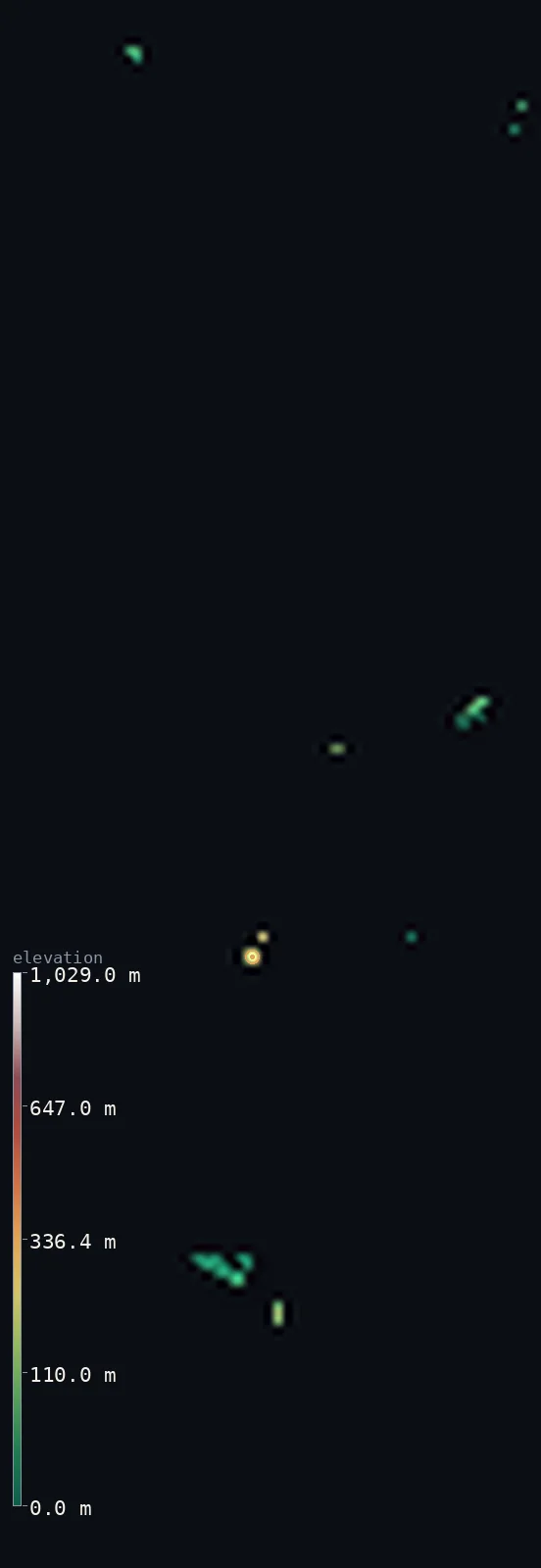
Tonga’s highest point is Kao at 3,389 ft (1,033 m); its lowest is Pacific Ocean at 0 ft (0 m); the mean elevation is 176 ft (53.6 m).
- Highest point📚
- 3,389 ft1,033 m
- Tonga's highest point is Kao, 1,033 m — a volcanic cone in the central Ha'apai group, standing far above the low coral of the main island, Tongatapu.
- Lowest point📚
- 0 ft0 m
- Sea level around the island.
- Mean elevation⚙
- 176 ft53.6 m
- Computed from the GLO-30 surface model across the rendered land.
- Median elevation⚙
- 94 ft28.5 m
- Half of Tonga lies below this height.
- Elevation range📚
- 3,389 ft1,033 m
- From the sea to the 1,033 m summit of Kao — almost all of Tonga is low coral, so nearly the whole range belongs to a few volcanic cones.
- Above 50 m (164 ft)⚙
- 29%
- The volcanic cones — Kao, Tofua — and raised islands like 'Eua that stand above Tonga's low coral.
- Official area📚
- 288 mi²747 km²
- A scattered kingdom of about 170 islands across the South Pacific — mostly low coral, with a handful of steep volcanic cones.
- Forest cover📚
- 12.5%
- Lightly wooded, mostly cultivated and settled.
Highest and lowest points
Tonga's highest point is Kao, 1,033 m - a steep volcanic cone in the central Ha'apai group, rising from the sea about 158 km north of the main island of Tongatapu. Tongatapu itself, the low and populous main island, reaches only about 77 m, a raised-coral platform with no volcanic relief. This map frames the whole island group, so the high point shown is Kao's summit rather than Tongatapu's low rise.
source ↗Tonga at a glance
Tonga's main island, Tongatapu, is so low that its highest ground is only about 77 m above the sea.
source ↗The kingdom's true high point, the volcano Kao, rises to about 1,033 m on a distant island some 158 km to the north.
source ↗Just west of the islands runs the Tonga Trench, whose Horizon Deep is over 10,000 m down.
source ↗Lying just west of the International Date Line, Tonga calls itself the place 'where time begins'.
source ↗The kingdom's roughly 170 islands are split between low coral isles and steep volcanic cones.
source ↗
Elevation profile of Tonga
The largest share of land, 47%, falls in the 0–20 m band, and 100% of the territory lies below 500 m (1,640 ft).
- 0–10 m (0–33 ft)24%
- 10–50 m (33–164 ft)48%
- above 50 m (164 ft)29%
Highest peaks of Tonga
| Peak | Elevation | Range | Note |
|---|---|---|---|
| Kao↗ | 3,389 ft1,033 m | Tonga Volcanic Arc (Ha'apai) | Tonga's national high point - a volcanic cone in the central Ha'apai group about 158 km north of the main island of Tongatapu, shown here because this map frames the whole island group. |
| Tofua↗ | 1,690 ft515 m | Tonga Volcanic Arc (Ha'apai) | An active volcano with a crater lake in the Ha'apai group, also beyond the rendered area. |
| 'Eua (highest ridge)↗ | 1,079 ft329 m | Tongatapu group | An old volcanic ridge on 'Eua island, southeast of Tongatapu; higher than Tongatapu but on a separate island not included here. |
Terrain regions of Tonga
Tonga's main island, Tongatapu, is so low that its highest ground is only about 77 m above the sea. ↗
Tongatapu (rendered here)
↗The low, flat, raised-coral main island in the south, holding the capital Nuku'alofa and most of the population - the island shown on this map.
The Ha'apai and volcanic islands
↗The central group of low coral islands and steep western volcanoes - Tofua and Kao, the latter Tonga's highest point - lying about 150-200 km north of Tongatapu.
Vava'u, 'Eua and the outer islands
↗The hilly northern Vava'u group, the higher island of 'Eua near Tongatapu, and the remote Niuas far to the north - all separate islands beyond this map.
Tongatapu, the main island
the rendered islandThis map shows Tongatapu, the largest and most populous island of Tonga at about 260 km2. It is a low, flat raised-coral platform capped with fertile volcanic soil, tilted so that it rises gently from a lagoon on the north to slightly higher ground - only around 77 m at most - in the south and southeast. The capital, Nuku'alofa, sits on its northern shore.
The volcanic high islands
the central volcanic islandsTonga's real heights lie on separate islands to the north, not shown here. In the central Ha'apai group, steep volcanic cones rise abruptly from the sea - Tofua, an active volcano with a crater lake, and Kao, whose summit at about 1,033 m is the highest point in the whole kingdom, roughly 158 km from Tongatapu.
The coral and outer islands
the outer islandsThe rest of Tonga is a scatter of about 170 islands across a wide stretch of the South Pacific - the low coral islands of Ha'apai, the hillier raised-limestone island group of Vava'u to the north (rising to around 200-300 m), the higher island of 'Eua near Tongatapu, and the remote Niua islands far to the north. All of these lie beyond the area rendered on this map.
City elevations in Tonga
| City | Population | Elevation |
|---|---|---|
| Nuku‘alofacapital | 22,400 | 16 ft5 m |
| Neiafu | 3,825 | 43 ft13 m |
| Fangale’ounga | 2,016 | 36 ft11 m |
| Hihifo | 301 | 16 ft5 m |
Elevation sampled at each city centre from the Copernicus GLO-30 model. Cities and population from GeoNames (CC-BY 4.0).
Tonga in comparison
Tonga's terrain rises 3,389 ft (1,033 m) from sea level to Kao — about 12% of the height of Mount Everest, the world's highest point at 29,032 ft (8,849 m).
- Samoa's mean elevation is 1,217 ft — 1,041 ft higher; its high point, Mount Silisili, reaches 6,096 ft (1,858 m), 2,707 ft above. Samoa elevation map →
- Fiji's mean elevation is 669 ft — 493 ft higher; its high point, Mount Tomanivi (Mount Victoria), reaches 4,344 ft (1,324 m), 955 ft above. Fiji elevation map →
- Vanuatu's mean elevation is 899 ft — 723 ft higher; its high point, Mount Tabwemasana, reaches 6,165 ft (1,879 m), 2,776 ft above. Vanuatu elevation map →
Frequently asked questions
What is the highest point in Tonga?
- Tonga's national high point is the summit of Kao, about 1,033 m, in the Ha'apai group. This map renders the main island, Tongatapu, whose own high point is only about 3,389 ft (1,033 m); Kao lies too far north to be shown here.
What is the average elevation of Tonga?
- No standard source publishes one, so this page reports the mean computed from the Copernicus GLO-30 model, 176 ft (53.6 m), over the low main island shown here.
What is the lowest point in Tonga?
- Sea level - the Pacific Ocean surrounds every island.
Why does this map show only about 77 m as the high point?
- Because it renders Tongatapu, the low main island. Tonga's high volcanic islands, including Kao (1,033 m), lie more than 150 km away across open sea and fall outside this island's rendered area.
How many islands does Tonga have?
- About 170 islands, of which roughly 36 are inhabited, scattered across a large area of the South Pacific.
Is this a topographic, relief, contour, or elevation map of Tonga?
- They describe the same thing - terrain height. This page renders Tonga's actual elevation surface in interactive 3D (a relief or topographic view) and reports the elevation statistics computed from it; a contour map shows the same data as lines of equal height.
About this map
The terrain is rendered from the Copernicus GLO-30 digital elevation model (ESA), masked to the TON-ADM0 boundary from geoBoundaries (gbOpen). Elevation statistics are computed directly from the model; peak names and researched facts are sourced and cited. See the methodology for the full pipeline.
Our area-weighted mean, computed from the Copernicus GLO-30 model, is 176 ft (53.6 m); no authority publishes a mean elevation (No authoritative published mean elevation). No standard source publishes a single mean elevation for Tonga. The main island shown here, Tongatapu, is a low raised-coral platform only tens of metres high; the page reports the area-weighted mean computed from the Copernicus GLO-30 model over the rendered land.
Surveyed national figures: official area · forest cover · high point.
Rendered from Copernicus GLO-30 (ESA, 2021 release), boundaries from geoBoundaries. Generated 2026-07-25.