Nauru Elevation Map — Topographic & 3D Terrain
Explore the terrain of Nauru in interactive 3D, built from Copernicus GLO-30 satellite elevation data — a single raised-coral island, a coastal ring rising to a mined-out central plateau. Drag to rotate, scroll to zoom, and tap any point to read its elevation.
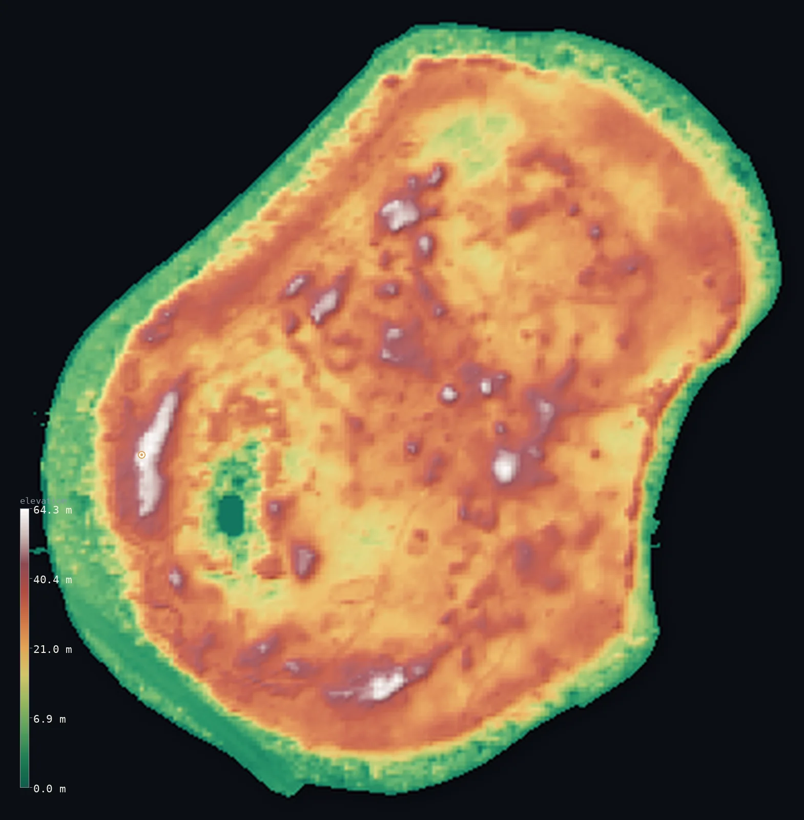
Nauru’s highest point is Command Ridge at 213 ft (65 m); its lowest is Pacific Ocean at 0 ft (0 m); the mean elevation is 79 ft (24 m).
Nauru is a single raised-coral island barely 8 sq mi (21 sq km) in area — the eroded cap of an ancient submarine volcano, lifted about 30 m above the sea and dissolved into karst. A sandy beach gives way to a fertile coastal ring, then cliffs rise to the central plateau, 'Topside', whose rim reaches 213 ft (65 m) at Command Ridge, the highest point. Half the island lies above about 86 ft (26.2 m). Over 80% of the interior has been strip-mined for phosphate, leaving a barren field of coral pinnacles.
- Highest point📚
- 213 ft65 m
- Nauru's highest point is Command Ridge at 213 ft (65 m), on the rim of the central raised phosphate plateau, 'Topside'. Nauru is a single raised-coral island, so its 'summit' is a low plateau rim, not a mountain; the site holds rusting World War II Japanese guns.
- Lowest point📚
- 0 ft0 m
- Nauru's lowest point is sea level, around the island's coast — a narrow fertile ring behind a sandy beach and a fringing reef that drops straight into the deep Pacific, with no natural harbour.
- Mean elevation⚙
- 79 ft24 m
- Computed from the GLO-30 model, Nauru's mean elevation is 79 ft (24 m) — for Nauru is a tiny raised-coral island whose rim reaches only 65 m. Half the island lies above about 86 ft (26.2 m): the raised interior plateau stands a little higher than the low coastal ring.
- Median elevation⚙
- 86 ft26.2 m
- Half of Nauru lies above about 86 ft (26.2 m) — slightly higher than the mean, because the central raised plateau ('Topside') stands above the narrow low coastal ring. The whole island rises only to 65 m at Command Ridge.
- Elevation range📚
- 213 ft65 m
- From the sea to Command Ridge at 65 m, Nauru's terrain spans just 213 ft — the low relief of a single raised-coral island, a coastal ring rising to a mined-out central plateau.
- Above 50 m (164 ft)⚙
- 1%
- About 1% of Nauru rises above 50 m (164 ft) — the higher parts of the central 'Topside' plateau around Command Ridge. The coastal ring where nearly everyone lives is lower.
- Official area📚
- 8 mi²21 km²
- Nauru covers about 8 sq mi (21 sq km) — a single raised-coral island, the eroded cap of an ancient submarine volcano lifted about 30 m above the sea, one of the smallest countries in the world.
- Forest cover📚
- 0%
- Effectively none of Nauru is forested — more than 80% of the island's interior has been strip-mined for phosphate, leaving a barren central plateau of jagged coral pinnacles; the greenery is a thin coastal ring.
Highest and lowest points
Nauru's highest point is Command Ridge, 213 ft (65 m), on the rim of the central raised-coral plateau, 'Topside'. On a single low island barely 21 km² in area, it is a plateau rim rather than a mountain — the whole country rises only this high. The ridge was a Japanese lookout in the Second World War, and rusting six-barrelled anti-aircraft guns and a bunker still stand there. Around and below it the strip-mined interior falls away in jagged coral pinnacles to the fertile coastal ring and the reef.
source ↗Nauru's lowest ground is its coast, at sea level — a fringing reef dropping steeply into the deep Pacific, with no natural harbour, behind a sandy beach and a fertile coastal ring 150–300 m wide where nearly all Nauruans live. From the ring, cliffs rise to 'Topside', the central raised-coral plateau, whose rim reaches 65 m at Command Ridge (the highest point) — a Japanese lookout in the Second World War, where rusted guns still stand. More than 80% of the plateau has been strip-mined for phosphate, leaving a barren interior of jagged coral pinnacles up to 15 m high; the one notable inland water is the small brackish Buada Lagoon in a southwestern hollow. The whole island — reef, ring and mined plateau — rises only to that 65 m rim.
source ↗Nauru at a glance
Nauru's highest point is just 65 m, on Command Ridge - the whole country is barely 21 km2, making it one of the smallest nations on Earth.
source ↗It is one of only three great raised phosphate-rock islands in the Pacific, alongside Banaba and Makatea.
source ↗More than 80% of the island has been strip-mined, leaving a central plateau of jagged coral pinnacles.
source ↗Nauru lies only about 53 km south of the Equator and has no rivers - fresh water comes mainly from rain and desalination.
source ↗Command Ridge was a Japanese lookout in World War II, and rusted six-barrelled guns and a bunker still stand there.
source ↗The island has no natural harbour - its fringing reef drops straight into deep ocean.
source ↗
Elevation profile of Nauru
The largest share of land, 21%, falls in the 25–30 m band, and 100% of the territory lies below 500 m (1,640 ft).
- 0–10 m (0–33 ft)18%
- 10–50 m (33–164 ft)81%
- above 50 m (164 ft)1%
Highest peaks of Nauru
| Peak | Elevation | Range | Note |
|---|---|---|---|
| Command Ridge↗ | 213 ft65 m | Topside plateau rim (interior) | Highest point of Nauru, on the rim of the central phosphate plateau. |
| Topside plateau (interior)↗ | 131 ft40 m | Topside plateau (centre) | The raised coral-limestone plateau filling the island's interior, averaging about 30 m and pitted with mining pinnacles. |
Nauru: the raised coral island, and the mined interior and Buada Lagoon
The raised coral island
Nauru is a single raised-coral island — the eroded cap of an ancient submarine volcano, lifted about 30 m above the sea. A sandy beach gives way to a fertile coastal ring 150–300 m wide, then cliffs rise to the central plateau, 'Topside', whose rim reaches 65 m at Command Ridge. There are no rivers, no substantial lakes and no natural harbour — just a fringing reef dropping steeply into the deep Pacific.
The mined interior and Buada Lagoon
Over 80% of the island's interior has been strip-mined for phosphate — ancient seabird guano — leaving a barren landscape of coral pinnacles up to 15 m high. The one notable inland water is Buada Lagoon, a small brackish lake in a southwestern hollow.
How to read this map
Color shows elevation; the raised relief shows real terrain. On this map Nauru reads as a single small island — a low coastal ring rising to the slightly higher central plateau ('Topside') around Command Ridge, the whole island only about 65 m at its highest.
Because Nauru is so small and low, the 3D relief is the actual GLO-30 elevation data exaggerated so the coastal ring and the raised plateau show; the ×N relief slider controls how much. Tap anywhere to read that point's exact elevation.
City elevations in Nauru
Nearly all Nauruans live on the fertile coastal ring, below the mined interior — Yaren, in the south, is the de facto capital and seat of government, with the harbour and phosphate works nearby at Aiwo on the west coast.
| City | Population | Elevation |
|---|---|---|
| Yarencapitalthe de facto capital, on the narrow fertile coastal ring in the island's south ↗ | 1,100 | 10 ft3 m |
Elevation sampled at each city centre from the Copernicus GLO-30 model. Cities and population from GeoNames (CC-BY 4.0).
Nauru in comparison
Nauru's terrain rises 213 ft (65 m) from sea level to Command Ridge — about 1% of the height of Mount Everest, the world's highest point at 29,032 ft (8,849 m).
- Tuvalu's mean elevation is 2 ft — 76 ft lower; its high point, Niulakita (unnamed high point), reaches 15 ft (4.6 m), 198 ft below. Tuvalu elevation map →
- Marshall Islands's mean elevation is 2 ft — 76 ft lower; its high point, Likiep high point (unnamed), reaches 33 ft (10 m), 180 ft below. Marshall Islands elevation map →
- Palau's mean elevation is 56 ft — 23 ft lower; its high point, Mount Ngerchelchuus, reaches 794 ft (242 m), 581 ft above. Palau elevation map →
Frequently asked questions
What is the highest point in Nauru?
- Command Ridge, 213 ft (65 m), on the rim of the central phosphate plateau.
What is the average elevation of Nauru?
- Nauru rises only to 65 m over a tiny area. The figure here is computed from the Copernicus GLO-30 surface model over the island.
What is the lowest point in Nauru?
- Sea level, around the island's coast.
Why is Nauru's interior so barren?
- More than 80% of the island has been strip-mined for phosphate, leaving the central 'Topside' plateau as a field of bare coral pinnacles.
How big is Nauru?
- About 21 km2 - a single raised-coral island and one of the smallest countries in the world.
Is this a topographic, relief, contour, or elevation map of Nauru?
- They describe the same thing - terrain height. This page renders Nauru's actual elevation surface in interactive 3D (a relief or topographic view) and reports the elevation statistics computed from it; a contour map shows the same data as lines of equal height.
About this map
The terrain is rendered from the Copernicus GLO-30 digital elevation model (ESA), masked to the NRU-ADM0 boundary from geoBoundaries (gbOpen). Elevation statistics are computed directly from the model; peak names and researched facts are sourced and cited. See the methodology for the full pipeline.
Our area-weighted mean, computed from the Copernicus GLO-30 model, is 79 ft (24 m); no authority publishes a mean elevation (no authoritative published mean). Nauru is a single raised-coral island barely 21 km² in area — the eroded cap of an ancient submarine volcano, lifted about 30 m above the sea and dissolved into karst. A sandy beach gives way to a fertile coastal ring 150–300 m wide, then cliffs rise to the central plateau, 'Topside', whose rim reaches 65 m at Command Ridge. Half the island lies above about 86 ft (26.2 m) — the raised interior standing a little above the low coastal ring. Over 80% of that interior has been strip-mined for phosphate — ancient seabird guano — leaving a barren field of coral pinnacles. There are no rivers and no natural harbour; the figure here is computed from the GLO-30 model.
Surveyed national figures: official area · forest cover · high point.
Rendered from Copernicus GLO-30 (ESA, 2021 release), boundaries from geoBoundaries. Generated 2026-06-25.