Antarctica Elevation Map
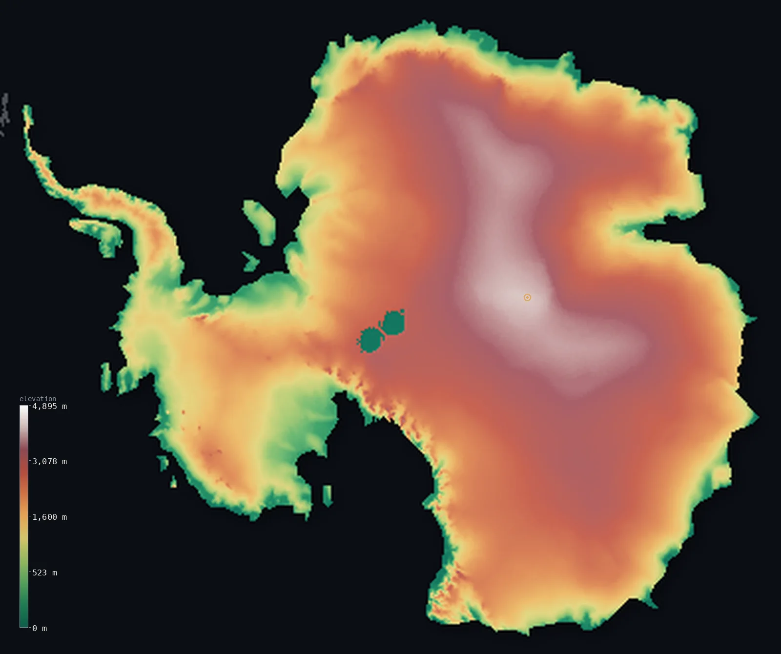
Antarctica’s highest point is Vinson Massif (Mount Vinson) at 16,050 ft (4,892 m); its lowest is Deep Lake, Vestfold Hills at −164 ft (−50 m); the mean elevation is 7,185 ft (2,190 m).
- Highest point📚
- 16,050 ft4,892 m
- Antarctica's highest point is Mount Vinson (the Vinson Massif) at 16,050 ft (4,892 m), in the Ellsworth Mountains of West Antarctica - a great snow-and-ice-covered massif, the highest of the ranges that rise through the ice sheet. It is one of the most remote major summits on Earth, hundreds of miles from any settlement, in a land where the mountains pierce a plateau of ice up to several kilometres thick.
- Lowest point📚
- −164 ft−50 m
- On this ice-surface map, Antarctica's terrain barely drops below sea level - the ice sheet meets the sea at the coast at close to sea level. The lowest exposed land is at Deep Lake in the Vestfold Hills, about 164 ft (50 m) below sea level, in one of the few ice-free coastal oases. But far lower ground lies hidden: beneath the ice, the bedrock of the Bentley Subglacial Trench sinks to about 8,333 ft (2,540 m) below sea level - the lowest point on Earth not under the ocean - buried under the ice sheet and not shown on this map of the ice surface.
- Mean elevation⚙
- 7,185 ft2,190 m
- Computed from the GLO-30 model, Antarctica's mean elevation is 7,185 ft (2,190 m) - the highest of any continent, because what the map shows is the surface of the great Antarctic ice sheet, which is several kilometres thick over much of the interior. Remarkably, the median is even higher: half the continent lies above about 7,644 ft (2,330 m), because the vast high interior ice plateau is the typical Antarctic surface, and only the lower coastal fringe drops away - the reverse of every other continent, where the high ground is the exception.
- Median elevation⚙
- 7,644 ft2,330 m
- Half of Antarctica lies above about 7,644 ft (2,330 m) - and, uniquely among the continents, this is higher than the mean. Antarctica is the one continent where the typical point is high: the vast interior ice plateau, kilometres thick, sits high across most of the land, while only the coastal fringe and the ice shelves drop lower, pulling the average down below the midpoint. Everywhere else on Earth the high ground is a minority; here it is the rule.
- Elevation range📚
- 16,214 ft4,942 m
- On the ice surface this map shows, Antarctica's terrain spans about 16,214 ft (4,942 m) - from the ice-free hollow of Deep Lake, 50 m below sea level, up to the summit of Mount Vinson at 4,892 m. Beneath the ice the land reaches far lower: the bedrock of the Bentley Subglacial Trench sinks to about 2,540 m below sea level, the lowest land on Earth outside the oceans - but that buried rock is not shown on this map of the ice surface.
- Above 1,000 m (3,281 ft)⚙
- 84%
- About 84% of Antarctica rises above 1,000 m (3,281 ft) - the great majority of it, for the surface shown is the great ice sheet, which climbs steeply from the coast to a vast high interior plateau kilometres thick. Only the coastal margins and the floating ice shelves lie lower.
- Above 2,000 m (6,562 ft)⚙
- 60%
- Roughly 60% of Antarctica stands above 2,000 m (6,562 ft) - the vast interior of the ice sheet, the high polar plateau that covers most of the continent, rising toward its center to over 4,000 m of ice and rock. The high, frozen heart of the southernmost continent.
- Official area📚
- 5,482,648 mi²14,200,000 km²
- Antarctica covers about 5,482,648 sq mi (14,200,000 sq km) - the fifth-largest continent, almost entirely buried under the Antarctic ice sheet, the largest single mass of ice on Earth, holding most of the world's fresh water. Mountain ranges - the Transantarctic Mountains, the Ellsworth Mountains (holding Mount Vinson) - rise through the ice, which climbs from the coast to a vast high interior plateau kilometres thick.
- Forest cover📚
- 0%
- Antarctica has no forest and essentially no vegetation - it is the coldest, driest, windiest continent, almost entirely covered by ice, with only lichens, mosses, and a few hardy plants clinging to the rare ice-free rock of the coast. The interior is a frozen desert of ice and snow.
Antarctica at a glance
Antarctica has the highest average elevation of any continent - about 2,190 m - almost entirely because of the ice sheet piled on top of it, not the rock beneath.
source ↗The ice sheet holds roughly 60% of the world's fresh water and averages nearly 2 km thick, reaching over 4.5 km at its deepest.
source ↗Beneath the ice, the Bentley Subglacial Trench drops to about 2,540 m below sea level - the lowest point on Earth's land surface, though it is covered by ice rather than ocean.
source ↗The weight of the ice has pushed much of the bedrock below sea level; if the ice were removed, the land would slowly rebound upward over thousands of years.
source ↗Mount Erebus on Ross Island is the southernmost active volcano on Earth and holds one of the world's few long-lived lava lakes.
source ↗
Elevation profile of Antarctica
The largest share of land, 18%, falls in the 2,500–3,000 m band, and 92% of the territory lies above 500 m (1,640 ft).
- below 500 m (1,640 ft)8%
- 500–1,000 m8%
- 1,000–2,000 m24%
- above 2,000 m (6,562 ft)60%
Highest and lowest points
The highest point of Antarctica is Mount Vinson (the high peak of the Vinson Massif), 4,892 m, in the Sentinel Range of the Ellsworth Mountains near the base of the Antarctic Peninsula. It is the most remote of the Seven Summits.
source ↗The lowest exposed land in Antarctica is at Deep Lake in the Vestfold Hills, about 50 m below sea level. Far deeper lies the Bentley Subglacial Trench, about 2,540 m below sea level - the lowest land on Earth not covered by ocean - but it is buried under the ice sheet and not shown on this ice-surface map.
source ↗Highest peaks of Antarctica
| Peak | Elevation | Range | Note |
|---|---|---|---|
| Vinson Massif (Mount Vinson)↗ | 16,050 ft4,892 m | Sentinel Range, Ellsworth Mountains | The highest point of Antarctica and the most remote of the Seven Summits. |
| Mount Tyree↗ | 15,919 ft4,852 m | Sentinel Range | The second-highest peak in Antarctica, near Vinson. |
| Mount Kirkpatrick↗ | 14,856 ft4,528 m | Queen Alexandra Range, Transantarctic Mountains | The highest peak of the Transantarctic Mountains. |
| Mount Sidley↗ | 14,058 ft4,285 m | Executive Committee Range (Marie Byrd Land) | The highest volcano in Antarctica, a dormant shield volcano. |
| Mount Erebus↗ | 12,448 ft3,794 m | Ross Island | The southernmost active volcano on Earth, with a persistent lava lake. |
Terrain regions of Antarctica
Antarctica has the highest average elevation of any continent - about 2,190 m - almost entirely because of the ice sheet piled on top of it, not the rock beneath. ↗
The polar plateau and ice sheet
~98% (the continent is almost entirely ice-covered)Most of Antarctica is a vast, high dome of ice - the polar plateau - rising above 4,000 m in East Antarctica. This ice surface, not the buried rock, is what gives the continent the highest mean elevation on Earth.
The Transantarctic Mountains
a narrow spine across the continentA great mountain chain over 3,500 km long divides East from West Antarctica, with peaks like Mount Kirkpatrick (4,528 m) piercing the ice. It is one of the longest mountain ranges on Earth, much of it buried to its shoulders in ice.
The Ellsworth Mountains and exposed rock
~2% ice-free (nunataks, dry valleys, coast)The highest peaks stand in the Ellsworth Mountains near the Antarctic Peninsula, crowned by Mount Vinson (4,892 m). Only about 2% of Antarctica is ice-free rock - scattered peaks, dry valleys and coastal margins.
Antarctica in comparison
Antarctica's terrain rises 16,214 ft (4,942 m) from Deep Lake, Vestfold Hills, 164 ft (50 m) below sea level to Vinson Massif (Mount Vinson) — about 56% of the height of Mount Everest, the world's highest point at 29,032 ft (8,849 m).
- World's mean elevation is 2,628 ft — 4,557 ft lower; its high point, Mount Everest, reaches 29,032 ft (8,849 m), 12,982 ft above. World elevation map →
- Asia's mean elevation is 2,631 ft — 4,554 ft lower; its high point, Mount Everest, reaches 29,032 ft (8,849 m), 12,982 ft above. Asia elevation map →
- South America's mean elevation is 1,906 ft — 5,279 ft lower; its high point, Aconcagua, reaches 22,838 ft (6,961 m), 6,788 ft above. South America elevation map →
Frequently asked questions
What is the highest point in Antarctica?
- Mount Vinson (the Vinson Massif), 16,050 ft (4,892 m), in the Ellsworth Mountains - one of the most remote major summits on Earth.
What is the lowest point in Antarctica?
- On the ice surface, the land barely drops below sea level; the lowest exposed land is Deep Lake (about 50 m below sea level). Beneath the ice, the bedrock of the Bentley Subglacial Trench reaches about 2,540 m below sea level - the lowest land on Earth outside the oceans - but it is buried under the ice and not shown here.
Why does this map show the ice surface instead of the land?
- Antarctica is almost entirely covered by an ice sheet averaging nearly 2 km thick. The Copernicus GLO-30 model measures the surface - here, the top of the ice - so this map shows the ice surface, which is what visitors and climbers actually stand on.
What is the average elevation of Antarctica?
- Computed from the GLO-30 model, about 7,185 ft (2,190 m) - the highest of any continent, because the map shows the surface of the ice sheet, kilometres thick over the interior. Uniquely, the median (7,644 ft (2,330 m)) is even higher.
Why is Antarctica the highest continent?
- Because what is measured is the surface of the Antarctic ice sheet, which is several kilometres thick over much of the interior - lifting the whole continent's surface far above the bedrock beneath.
Is this a topographic, relief, or elevation map of Antarctica?
- They describe the same thing - surface height. This page renders Antarctica's actual ice-surface elevation in interactive 3D, using a polar-stereographic projection suited to the pole, and reports the statistics computed from it.
How is this Antarctica map projected?
- It uses the Antarctic Polar Stereographic projection (EPSG:3031), centered on the South Pole - the standard way to map a polar cap, since an ordinary rectangular map would smear the continent into a distorted strip.
About this map
The terrain is rendered from the Copernicus GLO-30 digital elevation model (ESA), masked to the CONTINENT-ANTARCTICA boundary from geoBoundaries (naturalearth-110m). Elevation statistics are computed directly from the model; peak names and researched facts are sourced and cited. See the methodology for the full pipeline.
Because Antarctica covers 12,057,933 km², its 3D terrain surface is rendered at roughly 2.5 km per pixel rather than the model’s native 30 m — the full-resolution grid exceeds the render budget for an area this large. The high point and every elevation figure on this page are still measured at native 30 m resolution; only the rendered surface detail is coarsened.
Our area-weighted mean, computed from the Copernicus GLO-30 model, is 7,185 ft (2,190 m); no authority publishes a mean elevation (no single authoritative continental mean). Antarctica is unlike any other continent, and its elevation tells why. What this map shows is not bare land but the surface of the Antarctic ice sheet - the largest mass of ice on Earth, in places over four kilometres thick. That ice makes Antarctica the highest continent on Earth by average elevation: its mean is 7,185 ft (2,190 m). And uniquely, its median is higher still - half the continent lies above about 7,644 ft (2,330 m) - because the vast high interior ice plateau is the typical Antarctic surface, and only the lower coastal fringe drops away. On every other continent the high ground is the exception that lifts the average; on Antarctica the high ice plateau is the rule, and the low coast is the exception. Beneath the ice, the story reverses: the bedrock sinks in places far below sea level - the Bentley Subglacial Trench reaches about 2,540 m down, the lowest land on Earth outside the oceans - but that buried rock is not shown here, only the ice above it. (No single authoritative figure for the mean elevation of a whole continent is published; the value here is computed directly from the GLO-30 ice-surface elevation model.)
Surveyed national figures: official area · forest cover · high point.
Rendered from Copernicus GLO-30 (ESA, 2021 release), boundaries from geoBoundaries. Generated 2026-07-22.