Countries Below Sea Level
It’s tempting to picture whole countries sitting underwater behind a wall of dikes. The reality is more interesting, and more precise: no country is entirely below sea level, but a good number have real land below it — and until now, how much has never been gathered in one place.
Beyond “the Netherlands,” there has been no consolidated source for how much of each country lies below sea level. So we computed it — the share of every country’s land under 0 m, straight from Copernicus GLO-30, the European Space Agency’s 30-metre satellite model, clipped to each border, for all 194 countries.
Three questions hide inside “below sea level,” and we answer all three: whether any country is entirely below it (no), which countries have the most land below it (the missing dataset), and where the lowest points on land actually are.
Is any country entirely below sea level?
No. It is the question people actually search, and the answer is a clean one: not a single country sits wholly below sea level. Even the Netherlands, the country most associated with the idea, rises to 1,056 ft (322 m) at its highest and keeps roughly 77% of its land above the tideline. A nation entirely below the sea would need no high ground at all, anywhere — and none exists.
What’s true instead is narrower and more interesting: specific regions lie below sea level, held back by dikes, ringed by higher land, or sunk into a desert basin no water reaches. That is what the rest of this page measures.
Countries with the most land below sea level
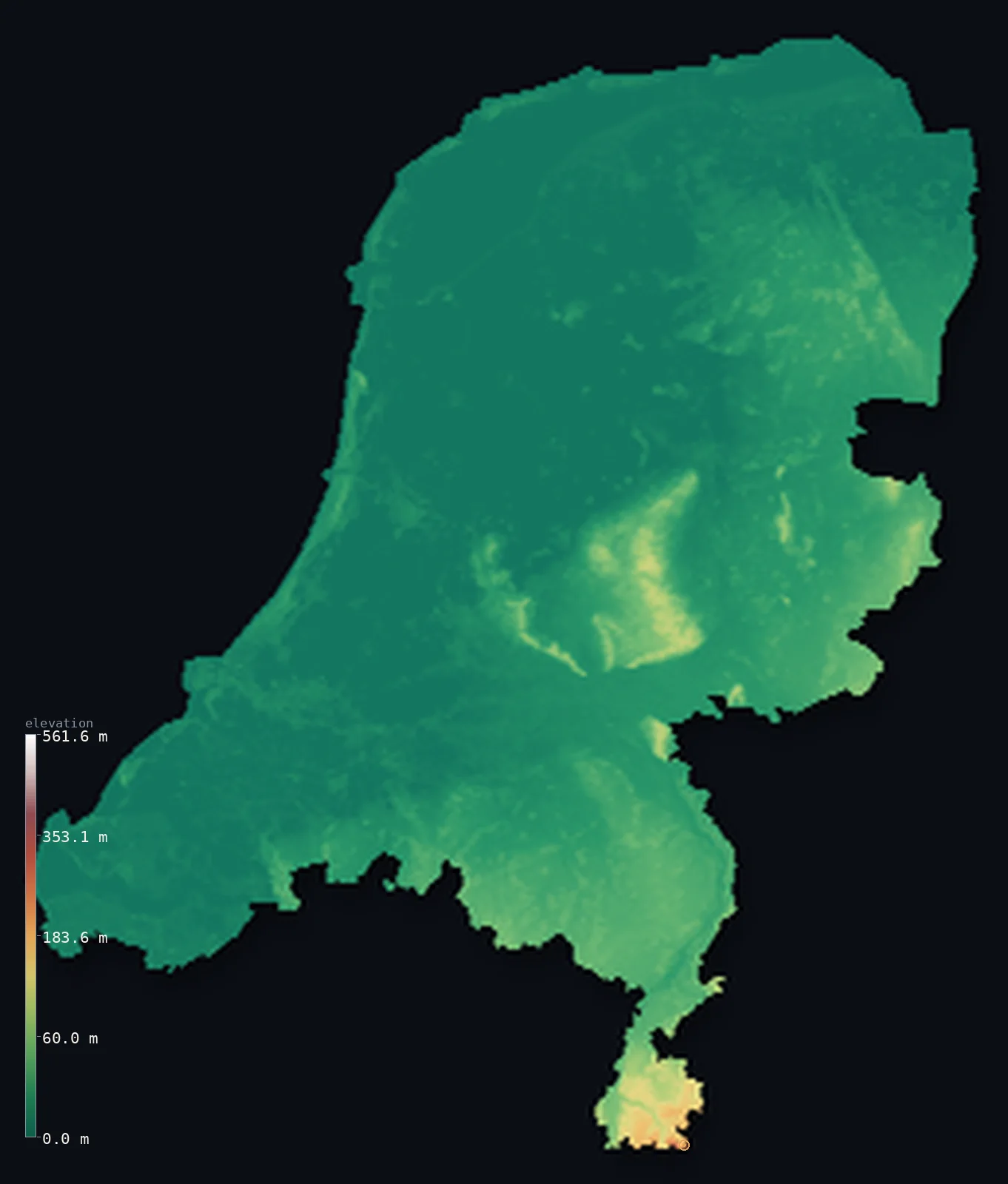
This is the figure that had never been collected: the share of each country’s area that sits below 0 m. The Netherlands leads by a wide margin — about 23% of it is below sea level, the polders held dry by centuries of engineering. Then come two Caspian countries, Azerbaijan (17%) and Turkmenistan (8%), whose land slopes down to a sea that is itself below the ocean.
After them the numbers fall away quickly: Israel (8%) around the Dead Sea, Kazakhstan (5%), Egypt (3%) at the Qattara Depression, Jordan (2%). In all, 24 countries have more than half a percent of their land below sea level. A few others — Italy’s Po delta, the Bahamas, low Gulf coastlines — dip below too, even where their lowest named point is nominally the sea.
Sort the table by share, by lowest-point depth, or alphabetically; each country links to its full 3D map.
| # | ||||
|---|---|---|---|---|
| 1 | Netherlands | 22.8% | Zuidplaspolder | −22 ft (−6.8 m) |
| 2 | Azerbaijan | 17.1% | Caspian Sea | −92 ft (−28 m) |
| 3 | Turkmenistan | 8.3% | Akjagaya Depression | −266 ft (−81 m) |
| 4 | Israel | 8.1% | Dead Sea shore | −1,411 ft (−430 m) |
| 5 | Kazakhstan | 5.2% | Karagiye Depression (Vpadina Kaundy) | −433 ft (−132 m) |
| 6 | Egypt | 2.8% | Qattara Depression | −436 ft (−133 m) |
| 7 | Jordan | 2.4% | Dead Sea shore | −1,411 ft (−430 m) |
| 8 | The Bahamas | 1.5% | Atlantic Ocean | at the coast |
| 9 | Italy | 1.3% | Mediterranean Sea | at the coast |
| 10 | Albania | 1.3% | Adriatic Sea | at the coast |
| 11 | Dominican Republic | 1.3% | Lago Enriquillo | −151 ft (−46 m) |
| 12 | Djibouti | 1.3% | Lake Assal | −509 ft (−155 m) |
| 13 | Eritrea | 1.2% | Danakil Depression (near Kulul / Kobar Sink) | −246 ft (−75 m) |
| 14 | Qatar | 1.0% | Persian Gulf | at the coast |
| 15 | Bahrain | 1.0% | Persian Gulf | at the coast |
| 16 | Tunisia | 1.0% | Chott el Gharsa | −56 ft (−17 m) |
| 17 | Germany | 0.8% | Neuendorf-Sachsenbande (Wilstermarsch) | −13 ft (−4 m) |
| 18 | Ethiopia | 0.7% | Danakil Depression (Afar) | −410 ft (−125 m) |
| 19 | Russia | 0.6% | Caspian Sea | −92 ft (−28 m) |
| 20 | Iran | 0.6% | Caspian Sea | −92 ft (−28 m) |
| 21 | United Kingdom | 0.6% | The Fens | −13 ft (−4 m) |
| 22 | Libya | 0.6% | Sabkhat Ghuzayyil | −154 ft (−47 m) |
| 23 | Denmark | 0.5% | Lammefjord | −23 ft (−7 m) |
| 24 | Mauritania | 0.5% | Sebkhet Te-n-Dghamcha | −16 ft (−5 m) |
A note on counting. Our dossiers record a named below-sea low point for 33 countries — close to the figure usually cited — while the raw model dips below 0 m in 120 countries, most of them only a hair below at the coastline, where a 30-metre model and the true waterline don’t perfectly agree. The table above uses the 0.5% floor to keep it to real below-sea land rather than that coastal noise.
The lowest points on land
The single deepest is the Dead Sea shore, about −1,411 ft (−430 m) below the sea in our dossier — the lowest exposed ground on Earth. That is the mid-2010s level, and it is a moving target: the lake is shrinking, and its surface has since fallen to roughly −1,443 ft (−440 m) (2025), dropping about 1.1 m a year and setting a fresh record most years. The Dead Sea is bordered by Jordan, Israel and the West Bank, and forms the lowest point of both Israel and Jordan; this page describes the terrain and takes no position on the boundaries around it.
Below the Dead Sea, the deepest points are a chain of desert basins where evaporation has scooped the land out beneath sea level: Lake Assal in Djibouti (−509 ft (−155 m) down), the Qattara Depression in Egypt (−436 ft (−133 m)), the Karagiye Depression in Kazakhstan (−433 ft (−132 m)), and the Danakil in Ethiopia (−410 ft (−125 m)). Farther out, Argentina’s Laguna del Carbón reaches −344 ft (−105 m), and Death Valley gives the United States a floor of −282 ft (−86 m).
The other great below-sea feature is the Caspian Sea, whose surface sits about −92 ft (−28 m) below the ocean. It is bordered by Azerbaijan, Iran, Kazakhstan, Russia and Turkmenistan, and its low shore is why those countries carry so much sub-sea land.
Why land sits below sea level
Three forces put ground below the sea, and each of the places above is one of them. Tectonics pulls the crust apart and drops it: the Dead Sea sits in the Jordan Rift, the Danakil where three plates separate — land sinking faster than sediment can fill it.
Evaporation does the rest in the desert basins. Where a low hollow has no outlet to the ocean and the sun removes water faster than rivers bring it, the surface draws down far below sea level — the Qattara and Karagiye depressions, the Caspian’s shrinking level. And reclamation is the human version: the Netherlands pumped its polders dry and lives on the sea floor behind dikes, the only entry on this list that is below sea level by design.
Low-lying land and rising seas
Land below sea level is only dry because something holds the water back — a dike, a ring of higher ground, or distance from the ocean. Where that something is a coastline, a rising sea narrows the margin. The Netherlands’s 23%, Egypt’s Nile Delta, the low Gulf coasts: these are the places where a few tens of centimetres of sea-level rise translate directly into land and people at risk.
The desert depressions are a separate case: far inland, in no danger of flooding — the Dead Sea is actually shrinking, its shore dropping year by year rather than drowning. “Below sea level” is one number covering two very different situations, and the table above tells them apart by pairing the share of low land with where that land actually sits.
Most land below sea level: Netherlands, about 23% of it — the polders, kept dry by dikes and pumps.
Lowest dry land on Earth: the Dead Sea shore, about −1,411 ft (−430 m) below the sea.
See the depressions in 3D
Our maps render these basins as real sub-zero geometry — the ground genuinely dips below the sea-level plane. See the Netherlands’s polders or Israel’s Dead Sea shore, browse the complete country index, or spin tight 3D renders of the five deepest basins — Death Valley, Lake Assal, Qattara and the Dead Sea among them — in the lowest point on Earth. For the flip side, the flattest countries and average elevation rankings cover the same 194 countries.
Frequently asked questions
- Is any country entirely below sea level?
- No. Every country has higher ground somewhere. Even the Netherlands rises to 1,056 ft (322 m) and keeps about 77% of its land above sea level.
- Which country has the most land below sea level?
- The Netherlands, with about 23% of its area below 0 m — far more than any other, followed by Azerbaijan (17%) and Turkmenistan (8%) along the Caspian.
- What is the lowest point on land?
- The Dead Sea shore, about −1,411 ft (−430 m) below sea level — the lowest exposed land on Earth, bordered by Jordan, Israel and the West Bank.
- Is the Netherlands below sea level?
- Partly — about 23% of it is, the most of any country, but not all: it also rises to 1,056 ft (322 m). The low parts are the polders, reclaimed land kept dry by dikes and pumps.
- Why are some places below sea level?
- Three reasons: tectonic rifts drop the crust (the Dead Sea, the Danakil); evaporation draws down enclosed desert basins with no outlet (Qattara, Karagiye); and humans reclaim land from the sea and pump it dry (the Dutch polders).
Methodology & sources
Elevation is from Copernicus GLO-30 (ESA, 2021 release), boundaries from geoBoundaries gbOpen; the share of land below sea level is computed here from each country’s elevation distribution; lowest points and their depths are researched figures from the dossiers. Two honest limits: a 30-metre model and the true coastline agree only approximately at 0 m, so tiny sub-sea slivers along coasts are model artifacts rather than real below-sea land — the table applies a 0.5% floor to exclude them — and the share is read from a binned distribution, so it is approximate. On disputed borders this page maps terrain only and takes no position. Country statistics current as of 2026-07-29; same first-party method as the methodology page describes, built by Marko Visic.
Related
- · Flattest countries in the world — low-lying and least-varying land, the same 194 countries.
- · Average elevation by country — ranked by height.
- · Most mountainous countries — the high-relief end.
- · Highest capital cities — Baku, the only below-sea capital, anchors the low end.
- · The lowest point on Earth — the Dead Sea, Challenger Deep, and the deepest land depressions.
- · More elevation deep-dives — the blog.
- · All countries by elevation — the full index, each with its 3D map.
Rendered from Copernicus GLO-30 (ESA, 2021 release); boundaries from geoBoundaries. Below-sea-level shares computed by 3D Elevation Map, 2026-07-29. Built by Marko Visic.