The Flattest States in the US
Everyone “knows” Kansas is the flattest state — flatter than a pancake, the saying goes. Measured properly, it isn’t close. It isn’t even in the top half.
The problem is how the popular lists measure flat. Almost every one ranks states by elevation range — the highest point minus the lowest — and even the sites that publish it admit that’s a crude proxy: two cherry-picked points can’t describe a whole state, and one stray peak wrecks the number.
So we measured flatness a better way, for all 50 states, from the Copernicus GLO-30 satellite elevation model: the variation of the entire surface — how much the land strays from its own average height, border to border. Below is that ranking, the Kansas myth resolved with our own data, and a table you can re-sort.
- 1Floridaσ 17.8 m
- 2Delawareσ 18.7 m
- 3Louisianaσ 30.4 m
- 4Illinoisσ 39.8 m
- 5Mississippiσ 42.4 m
- 6Indianaσ 50.4 m
- 7Ohioσ 52.4 m
- 8Rhode Islandσ 60 m
- 9Iowaσ 66.8 m
- 10Minnesotaσ 68.1 m
The flattest states
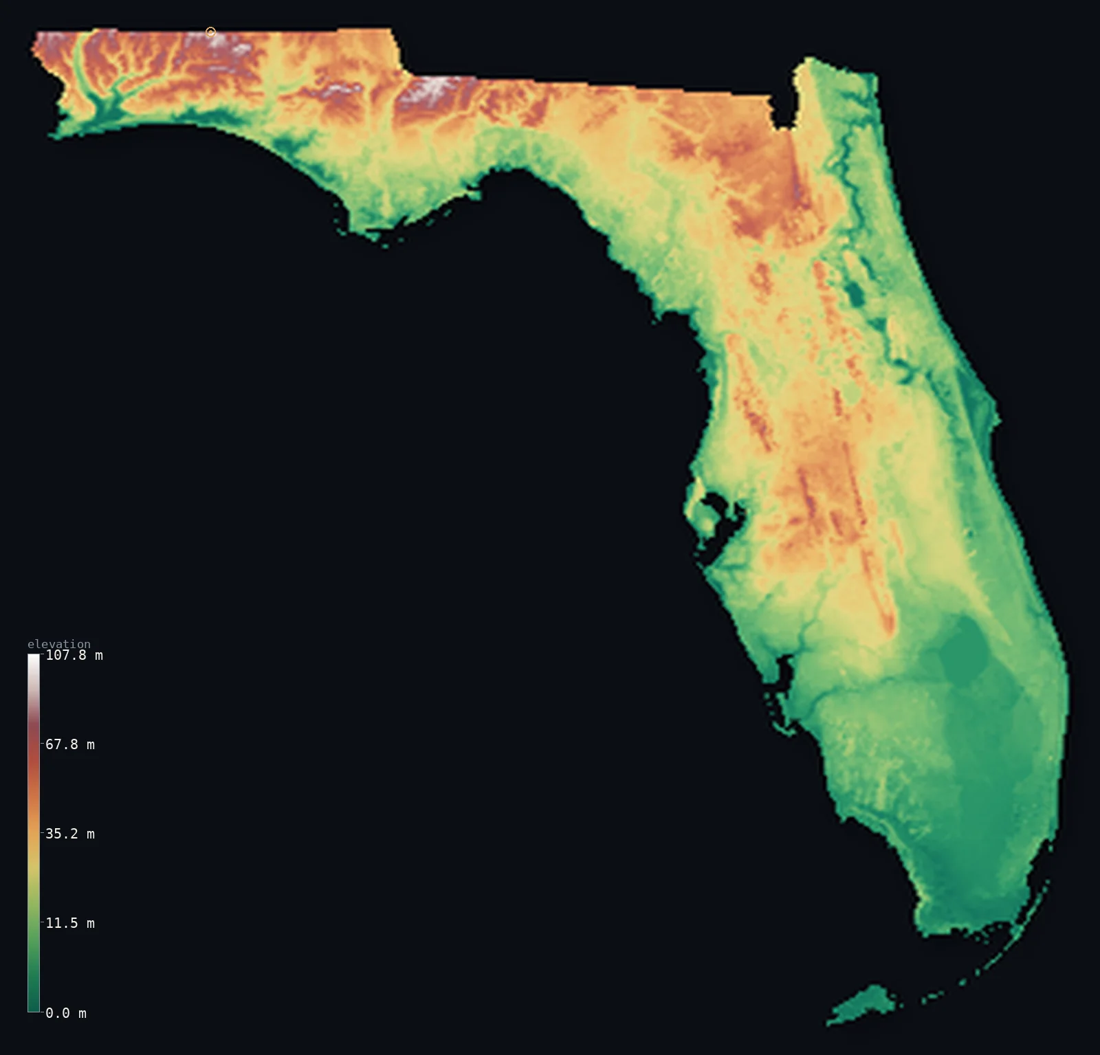
By whole-state variation, Florida is the flattest state in the country, and it isn’t close — a standard deviation of just 17.8 m, with a high point (Britton Hill) only 344 ft (105 m) above the sea. Delaware (18.7 m) and Louisiana (30.4 m) round out the top three: coastal-plain states where the ground barely leaves sea level.
Right behind them comes a different kind of flat — the glaciated Midwest. Illinois, Indiana, Ohio and Iowa all rank in the top ten by our measure, whole states planed smooth by the Ice Age. They sit higher than the coastal plain — Illinois averages 627 ft (191 m) — but their surface is every bit as level, which is the point of measuring the whole thing rather than two endpoints.
All 50 states, ranked by flatness
Sort by ruggedness σ (our flatness measure), by elevation range (the crude method), by mean or by highest point — the order changes with each. It opens on σ, ascending: the flattest first. Every state links to its full interactive 3D relief map.
| # | |||||
|---|---|---|---|---|---|
| 1 | Florida | 17.8 m | 410 ft (125 m) | 70 ft (21.3 m) | Britton Hill 344 ft (105 m) |
| 2 | Delaware | 18.7 m | 551 ft (168 m) | 61 ft (18.5 m) | Ebright Azimuth 449 ft (137 m) |
| 3 | Louisiana | 30.4 m | 598 ft (182 m) | 108 ft (32.8 m) | Driskill Mountain 535 ft (163 m) |
| 4 | Illinois | 39.8 m | 1,152 ft (351 m) | 627 ft (191 m) | Charles Mound 1,234 ft (376 m) |
| 5 | Mississippi | 42.4 m | 823 ft (251 m) | 305 ft (92.9 m) | Woodall Mountain 807 ft (246 m) |
| 6 | Indiana | 50.4 m | 1,030 ft (314 m) | 751 ft (229 m) | Hoosier Hill 1,257 ft (383 m) |
| 7 | Ohio | 52.4 m | 1,129 ft (344 m) | 935 ft (285 m) | Campbell Hill 1,549 ft (472 m) |
| 8 | Rhode Island | 60 m | 885 ft (270 m) | 270 ft (82.2 m) | Jerimoth Hill 810 ft (247 m) |
| 9 | Iowa | 66.8 m | 1,217 ft (371 m) | 1,066 ft (325 m) | Hawkeye Point 1,670 ft (509 m) |
| 10 | Minnesota | 68.1 m | 1,713 ft (522 m) | 1,220 ft (372 m) | Eagle Mountain 2,300 ft (701 m) |
| 11 | Missouri | 79.7 m | 1,709 ft (521 m) | 860 ft (262 m) | Taum Sauk Mountain 1,772 ft (540 m) |
| 12 | Michigan | 80.6 m | 1,614 ft (492 m) | 912 ft (278 m) | Mount Arvon 1,978 ft (603 m) |
| 13 | Wisconsin | 86.1 m | 1,503 ft (458 m) | 1,093 ft (333 m) | Timms Hill 1,952 ft (595 m) |
| 14 | New Jersey | 90.4 m | 1,865 ft (568 m) | 240 ft (73.3 m) | High Point 1,804 ft (550 m) |
| 15 | Alabama | 92.7 m | 2,434 ft (742 m) | 476 ft (145 m) | Cheaha Mountain 2,411 ft (735 m) |
| 16 | South Carolina | 94.6 m | 3,862 ft (1,177 m) | 341 ft (104 m) | Sassafras Mountain 3,560 ft (1,085 m) |
| 17 | Connecticut | 103 m | 2,385 ft (727 m) | 489 ft (149 m) | Mount Frissell (south slope) 2,379 ft (725 m) |
| 18 | Kentucky | 110 m | 4,203 ft (1,281 m) | 840 ft (256 m) | Black Mountain 4,144 ft (1,263 m) |
| 19 | Arkansas | 141 m | 2,713 ft (827 m) | 541 ft (165 m) | Magazine Mountain 2,753 ft (839 m) |
| 20 | Georgia | 147 m | 4,918 ft (1,499 m) | 522 ft (159 m) | Brasstown Bald 4,783 ft (1,458 m) |
| 21 | North Dakota | 156 m | 2,726 ft (831 m) | 1,827 ft (557 m) | White Butte 3,507 ft (1,069 m) |
| 22 | Massachusetts | 158 m | 3,691 ft (1,125 m) | 558 ft (170 m) | Mount Greylock 3,488 ft (1,063 m) |
| 23 | Pennsylvania | 165 m | 3,389 ft (1,033 m) | 1,270 ft (387 m) | Mount Davis 3,212 ft (979 m) |
| 24 | Maine | 172 m | 5,358 ft (1,633 m) | 771 ft (235 m) | Mount Katahdin 5,269 ft (1,606 m) |
| 25 | Maryland | 190 m | 3,530 ft (1,076 m) | 429 ft (131 m) | Hoye-Crest (Backbone Mountain) 3,360 ft (1,024 m) |
| 26 | Tennessee | 196 m | 6,467 ft (1,971 m) | 965 ft (294 m) | Clingmans Dome 6,644 ft (2,025 m) |
| 27 | Vermont | 199 m | 4,350 ft (1,326 m) | 1,234 ft (376 m) | Mount Mansfield 4,393 ft (1,339 m) |
| 28 | New York | 204 m | 5,495 ft (1,675 m) | 1,125 ft (343 m) | Mount Marcy 5,344 ft (1,629 m) |
| 29 | New Hampshire | 232 m | 6,280 ft (1,914 m) | 1,152 ft (351 m) | Mount Washington 6,289 ft (1,917 m) |
| 30 | Oklahoma | 234 m | 4,675 ft (1,425 m) | 1,293 ft (394 m) | Black Mesa 4,974 ft (1,516 m) |
| 31 | Kansas | 251 m | 3,337 ft (1,017 m) | 1,909 ft (582 m) | Mount Sunflower 4,042 ft (1,232 m) |
| 32 | West Virginia | 259 m | 4,698 ft (1,432 m) | 1,699 ft (518 m) | Spruce Knob 4,862 ft (1,482 m) |
| 33 | South Dakota | 268 m | 6,240 ft (1,902 m) | 2,185 ft (666 m) | Black Elk Peak 7,241 ft (2,207 m) |
| 34 | Virginia | 284 m | 5,896 ft (1,797 m) | 1,010 ft (308 m) | Mount Rogers 5,728 ft (1,746 m) |
| 35 | North Carolina | 302 m | 6,795 ft (2,071 m) | 771 ft (235 m) | Mount Mitchell 6,683 ft (2,037 m) |
| 36 | Nebraska | 307 m | 4,583 ft (1,397 m) | 2,605 ft (794 m) | Panorama Point 5,423 ft (1,653 m) |
| 37 | Texas | 418 m | 8,691 ft (2,649 m) | 1,657 ft (505 m) | Guadalupe Peak 8,750 ft (2,667 m) |
| 38 | Nevada | 430 m | 12,618 ft (3,846 m) | 5,528 ft (1,685 m) | Boundary Peak 13,140 ft (4,005 m) |
| 39 | Alaska | 448 m | 20,302 ft (6,188 m) | 1,496 ft (456 m) | Denali 20,308 ft (6,190 m) |
| 40 | New Mexico | 457 m | 10,318 ft (3,145 m) | 5,774 ft (1,760 m) | Wheeler Peak 13,166 ft (4,013 m) |
| 41 | Utah | 473 m | 11,322 ft (3,451 m) | 6,014 ft (1,833 m) | Kings Peak 13,517 ft (4,120 m) |
| 42 | Washington | 481 m | 14,485 ft (4,415 m) | 2,290 ft (698 m) | Mount Rainier 14,409 ft (4,392 m) |
| 43 | Wyoming | 499 m | 10,623 ft (3,238 m) | 6,398 ft (1,950 m) | Gannett Peak 13,809 ft (4,209 m) |
| 44 | Montana | 508 m | 10,853 ft (3,308 m) | 4,137 ft (1,261 m) | Granite Peak 12,808 ft (3,904 m) |
| 45 | Idaho | 515 m | 11,844 ft (3,610 m) | 5,240 ft (1,597 m) | Borah Peak 12,661 ft (3,859 m) |
| 46 | Oregon | 536 m | 11,178 ft (3,407 m) | 3,533 ft (1,077 m) | Mount Hood 11,250 ft (3,429 m) |
| 47 | Arizona | 631 m | 12,536 ft (3,821 m) | 4,216 ft (1,285 m) | Humphreys Peak 12,638 ft (3,852 m) |
| 48 | Colorado | 692 m | 11,083 ft (3,378 m) | 6,867 ft (2,093 m) | Mount Elbert 14,439 ft (4,401 m) |
| 49 | California | 722 m | 14,747 ft (4,495 m) | 2,802 ft (854 m) | Mount Whitney 14,505 ft (4,421 m) |
| 50 | Hawaii | 904 m | 13,809 ft (4,209 m) | 3,904 ft (1,190 m) | Mauna Kea 13,796 ft (4,205 m) |
Is Kansas really flat? The pancake myth
The stereotype is old and sticky — a 2003 study in the Annals of Improbable Research even declared Kansas “flatter than a pancake.” But the serious version, a 2014 geomorphometric study of all 50 states, found something else: Florida is the flattest state, and Kansas ranks only about 20th (Dobson & Campbell, “The Flatness of U.S. States,” Geographical Review, 2014).
That study opens with just how deep the misconception runs. In its national survey, 33% of Americans named Kansas the flattest state and only 23% named Florida — and 77% failed to recognize Florida’s flatness at all, including 62% of Florida’s own residents. The pancake beats the data in people’s heads.
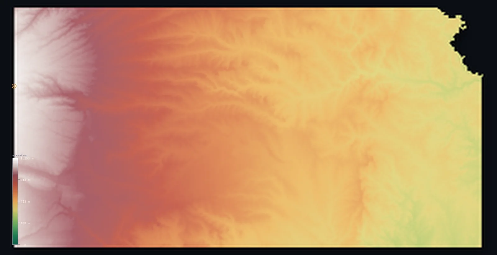
Our data says the same, more emphatically. By whole-state σ, Kansas ranks #31 of 50 — nowhere near flat. The reason is a tilt you can’t see standing in a wheat field: Kansas rises steadily from about 702 ft in the east to 4,039 ft (1,231 m) at the Colorado line, a climb of 3,337 ft (1,017 m) across the state.
That gradual ramp gives Kansas real whole-state relief — a mean of 1,909 ft (582 m) and an elevation that spreads over thousands of feet — even though any given horizon looks pancake-flat. It is locally smooth but regionally steep, and a measure of the whole surface catches what the eye (and the pancake) miss.
Why the usual flatness rankings mislead
The popular lists rank flatness by elevation range — highest point minus lowest. It’s intuitive, but it’s two points describing a whole state, and it breaks in both directions. One tall peak in a corner makes a flat state look rugged; a state with no single peak looks flat even if the whole surface rolls.
Alaska is the clearest case. It has the largest range of any state — Denali towers over tidewater — so the range method ranks it the least flat, #50 of 50. But most of Alaska is low coastal tundra, so by whole-state σ it sits at #39. Georgia runs the same way (29th by range, 20th by σ): one Appalachian summit inflates its range, while the coastal plain that is most of the state is genuinely flat.
Our measure — the standard deviation of elevation across the whole state — asks a different question: how much does the land vary from its own average, everywhere? That is the everyday sense of “flat,” and it is far harder to fool with a single point. It is the same first-party method behind our flattest countries and most mountainous countries rankings.
What makes a state flat
Two very different histories produce flat land, and our top ten holds both. The first is the coastal plain — Florida, Delaware, Louisiana, the Mississippi and Atlantic lowlands — young sediment that has never been pushed up into mountains. Florida in particular is a limestone platform barely emerged from the sea; its whole surface sits within a few metres of it.
The second is glaciation. The Ice Age sheets that ground across the Upper Midwest scraped the terrain smooth and filled the valleys with till, leaving Illinois, Indiana, Ohio and Iowa broad and level well above sea level. Coastal or glaciated, the result our data measures is the same: a surface that holds a near-constant height for hundreds of miles.
The least flat states
At the opposite end sits the mountain west. By whole-state σ the least flat state is Hawaii (904 m), followed by California, Colorado and Arizona — states where the land climbs and drops by thousands of feet across nearly every county. They are the exact inverse of this list: the same σ measure, read from the top down, ranks the most mountainous states. These are also the states that top our average elevation by state ranking, where the national high points live.
Flattest state: Florida. Its elevation varies by a standard deviation of 17.8 m — the whole state, effectively a single low contour.
The Kansas surprise: not the flattest, but #31 — its 3,337 ft (1,017 m) east-to-west rise gives it more whole-state relief than 19 other states.
See any state in 3D
Every state in the table links to its full interactive elevation map, where a flat state renders as an almost unbroken plane. Spin Florida or Illinois and the land barely moves; open Kansas and you can see the western ramp that the pancake myth ignores.
We’re mapping the same terrain city by city, too — each with a fine-resolution 3D view and its own elevation, like Denver. Browse the full state index, or read what a city’s elevation figure actually measures in elevation vs altitude.
Frequently asked questions
- What is the flattest state in the US?
- Florida. By whole-state terrain variation computed from Copernicus GLO-30, its elevation varies by a standard deviation of only 17.8 m — less than any other state. Delaware and Louisiana are next.
- Is Kansas the flattest state?
- No — that’s a myth. By our whole-state measure Kansas ranks #31 of 50, and the 2014 study that examined the question put it around 20th, with Florida first.
- Why isn’t Kansas the flattest state?
- Because it tilts. Kansas rises from about 702 ft in the east to 4,039 ft (1,231 m) at the Colorado border — a 3,337 ft (1,017 m) climb that gives the state real relief, even though any single view looks flat.
- What is the least flat state?
- Hawaii, whose elevation varies by a standard deviation of 904 m — the most rugged surface of any state. California and Colorado follow.
- How is flatness measured here?
- By the standard deviation of elevation across the whole state — how far the land strays from its own average height, everywhere — rather than the highest-point-minus-lowest range the popular lists use. It’s a whole-surface measure, so one peak can’t skew it.
- What’s the flattest state to live in?
- If you mean level ground underfoot, Florida and the Gulf-coast states are as flat as it gets, with the glaciated Midwest — Illinois, Indiana, Iowa — close behind on our ranking.
Methodology & sources
Elevation is from Copernicus GLO-30 (ESA, 2021 release), clipped to each state’s boundary. The ruggedness σ is the standard deviation of elevation, computed here from each state’s elevation distribution — GLO-30 ships no such field, so it is derived and, because the distribution is binned, approximate; the ranking it produces is robust. The pancake myth is resolved against Dobson & Campbell, “The Flatness of U.S. States” (Geographical Review, 2014). State statistics current as of 2026-07-14; same first-party method as the methodology page describes, built by Marko Visic.
Related
- · Flattest countries in the world — the same measure, worldwide: which nations vary least in height.
- · Average elevation by state — the sibling ranking, the 50 states by height rather than flatness.
- · The most mountainous states in the US — the direct inverse: the same 50 states at the high-relief end (and the Alaska-vs-Denali paradox).
- · Most mountainous countries — the opposite end of the very same σ measure, worldwide.
- · All 50 states by elevation — the full index, each with its interactive 3D map.
- · More elevation deep-dives — the blog.
Rendered from Copernicus GLO-30 (ESA, 2021 release). Flatness measures computed by 3D Elevation Map, 2026-07-14. Built by Marko Visic.