The Most Mountainous States in the US
Colorado, Alaska, Wyoming — ask which state is most mountainous and you’ll get an argument. The lists don’t help, because they can’t agree on the question: some rank by average height, some by a peak, some by an opaque “percent mountainous” dataset that somehow puts Colorado 13th.
The fix is one consistent measure applied to every state. We rank all 50 states by whole-state ruggedness — how much the terrain varies across the state — computed from the Copernicus GLO-30 satellite elevation model, alongside the share of land at high altitude and the mean.
It resolves the argument, and it exposes a paradox: the state with the tallest mountain in North America isn’t among the most mountainous at all.
- 1Hawaiiσ 904 m
- 2Californiaσ 722 m
- 3Coloradoσ 692 m
- 4Arizonaσ 631 m
- 5Oregonσ 536 m
- 6Idahoσ 515 m
- 7Montanaσ 508 m
- 8Wyomingσ 499 m
- 9Washingtonσ 481 m
- 10Utahσ 473 m
The most mountainous states by ruggedness
By whole-state variation, the most mountainous state is Hawaii (σ 904 m): its islands climb from sea level to nearly 14,000 ft, so almost no other terrain varies as violently. California (722 m) is second — the Sierra Nevada against the floor of Death Valley — and Colorado (692 m) third.
But if by “mountainous” you mean how high the land actually sits, Colorado is the clear leader — the highest mean elevation of any state (6,867 ft (2,093 m)) and 29% of its land above 2,500 m, more than any other. Wyoming and Utah follow. Hawaii and California vary the most; Colorado sits the highest — two honest answers to one question.
All 50 states, ranked by ruggedness
Sort by ruggedness σ, by the share of land above 2,500 m or 1,500 m, by mean, or by highest point — the order shifts with each. It opens on σ, descending: the most rugged first. Every state links to its full interactive 3D relief map.
| # | ||||||
|---|---|---|---|---|---|---|
| 1 | Hawaii | 904 m | 9.8% | 33% | 3,904 ft (1,190 m) | Mauna Kea 13,796 ft (4,205 m) |
| 2 | California | 722 m | 3.3% | 19% | 2,802 ft (854 m) | Mount Whitney 14,505 ft (4,421 m) |
| 3 | Colorado | 692 m | 29% | 74% | 6,867 ft (2,093 m) | Mount Elbert 14,439 ft (4,401 m) |
| 4 | Arizona | 631 m | 1.3% | 45% | 4,216 ft (1,285 m) | Humphreys Peak 12,638 ft (3,852 m) |
| 5 | Oregon | 536 m | 0.1% | 22% | 3,533 ft (1,077 m) | Mount Hood 11,250 ft (3,429 m) |
| 6 | Idaho | 515 m | 4.5% | 57% | 5,240 ft (1,597 m) | Borah Peak 12,661 ft (3,859 m) |
| 7 | Montana | 508 m | 2.4% | 27% | 4,137 ft (1,261 m) | Granite Peak 12,808 ft (3,904 m) |
| 8 | Wyoming | 499 m | 13% | 77% | 6,398 ft (1,950 m) | Gannett Peak 13,809 ft (4,209 m) |
| 9 | Washington | 481 m | 0.1% | 7.7% | 2,290 ft (698 m) | Mount Rainier 14,409 ft (4,392 m) |
| 10 | Utah | 473 m | 10% | 72% | 6,014 ft (1,833 m) | Kings Peak 13,517 ft (4,120 m) |
| 11 | New Mexico | 457 m | 5.9% | 65% | 5,774 ft (1,760 m) | Wheeler Peak 13,166 ft (4,013 m) |
| 12 | Alaska | 448 m | 0.4% | 4.3% | 1,496 ft (456 m) | Denali 20,308 ft (6,190 m) |
| 13 | Nevada | 430 m | 2.7% | 70% | 5,528 ft (1,685 m) | Boundary Peak 13,140 ft (4,005 m) |
| 14 | Texas | 418 m | 0.0% | 1.5% | 1,657 ft (505 m) | Guadalupe Peak 8,750 ft (2,667 m) |
| 15 | Nebraska | 307 m | 0.0% | 0.9% | 2,605 ft (794 m) | Panorama Point 5,423 ft (1,653 m) |
| 16 | North Carolina | 302 m | 0.0% | 0.4% | 771 ft (235 m) | Mount Mitchell 6,683 ft (2,037 m) |
| 17 | Virginia | 284 m | 0.0% | 0.0% | 1,010 ft (308 m) | Mount Rogers 5,728 ft (1,746 m) |
| 18 | South Dakota | 268 m | 0.0% | 1.9% | 2,185 ft (666 m) | Black Elk Peak 7,241 ft (2,207 m) |
| 19 | West Virginia | 259 m | 0.0% | 0.0% | 1,699 ft (518 m) | Spruce Knob 4,862 ft (1,482 m) |
| 20 | Kansas | 251 m | 0.0% | 0.0% | 1,909 ft (582 m) | Mount Sunflower 4,042 ft (1,232 m) |
| 21 | Oklahoma | 234 m | 0.0% | 0.0% | 1,293 ft (394 m) | Black Mesa 4,974 ft (1,516 m) |
| 22 | New Hampshire | 232 m | 0.0% | 0.1% | 1,152 ft (351 m) | Mount Washington 6,289 ft (1,917 m) |
| 23 | New York | 204 m | 0.0% | 0.0% | 1,125 ft (343 m) | Mount Marcy 5,344 ft (1,629 m) |
| 24 | Vermont | 199 m | 0.0% | 0.0% | 1,234 ft (376 m) | Mount Mansfield 4,393 ft (1,339 m) |
| 25 | Tennessee | 196 m | 0.0% | 0.1% | 965 ft (294 m) | Clingmans Dome 6,644 ft (2,025 m) |
| 26 | Maryland | 190 m | 0.0% | 0.0% | 429 ft (131 m) | Hoye-Crest (Backbone Mountain) 3,360 ft (1,024 m) |
| 27 | Maine | 172 m | 0.0% | 0.0% | 771 ft (235 m) | Mount Katahdin 5,269 ft (1,606 m) |
| 28 | Pennsylvania | 165 m | 0.0% | 0.0% | 1,270 ft (387 m) | Mount Davis 3,212 ft (979 m) |
| 29 | Massachusetts | 158 m | 0.0% | 0.0% | 558 ft (170 m) | Mount Greylock 3,488 ft (1,063 m) |
| 30 | North Dakota | 156 m | 0.0% | 0.0% | 1,827 ft (557 m) | White Butte 3,507 ft (1,069 m) |
| 31 | Georgia | 147 m | 0.0% | 0.0% | 522 ft (159 m) | Brasstown Bald 4,783 ft (1,458 m) |
| 32 | Arkansas | 141 m | 0.0% | 0.0% | 541 ft (165 m) | Magazine Mountain 2,753 ft (839 m) |
| 33 | Kentucky | 110 m | 0.0% | 0.0% | 840 ft (256 m) | Black Mountain 4,144 ft (1,263 m) |
| 34 | Connecticut | 103 m | 0.0% | 0.0% | 489 ft (149 m) | Mount Frissell (south slope) 2,379 ft (725 m) |
| 35 | South Carolina | 94.6 m | 0.0% | 0.0% | 341 ft (104 m) | Sassafras Mountain 3,560 ft (1,085 m) |
| 36 | Alabama | 92.7 m | 0.0% | 0.0% | 476 ft (145 m) | Cheaha Mountain 2,411 ft (735 m) |
| 37 | New Jersey | 90.4 m | 0.0% | 0.0% | 240 ft (73.3 m) | High Point 1,804 ft (550 m) |
| 38 | Wisconsin | 86.1 m | 0.0% | 0.0% | 1,093 ft (333 m) | Timms Hill 1,952 ft (595 m) |
| 39 | Michigan | 80.6 m | 0.0% | 0.0% | 912 ft (278 m) | Mount Arvon 1,978 ft (603 m) |
| 40 | Missouri | 79.7 m | 0.0% | 0.0% | 860 ft (262 m) | Taum Sauk Mountain 1,772 ft (540 m) |
| 41 | Minnesota | 68.1 m | 0.0% | 0.0% | 1,220 ft (372 m) | Eagle Mountain 2,300 ft (701 m) |
| 42 | Iowa | 66.8 m | 0.0% | 0.0% | 1,066 ft (325 m) | Hawkeye Point 1,670 ft (509 m) |
| 43 | Rhode Island | 60 m | 0.0% | 0.0% | 270 ft (82.2 m) | Jerimoth Hill 810 ft (247 m) |
| 44 | Ohio | 52.4 m | 0.0% | 0.0% | 935 ft (285 m) | Campbell Hill 1,549 ft (472 m) |
| 45 | Indiana | 50.4 m | 0.0% | 0.0% | 751 ft (229 m) | Hoosier Hill 1,257 ft (383 m) |
| 46 | Mississippi | 42.4 m | 0.0% | 0.0% | 305 ft (92.9 m) | Woodall Mountain 807 ft (246 m) |
| 47 | Illinois | 39.8 m | 0.0% | 0.0% | 627 ft (191 m) | Charles Mound 1,234 ft (376 m) |
| 48 | Louisiana | 30.4 m | 0.0% | 0.0% | 108 ft (32.8 m) | Driskill Mountain 535 ft (163 m) |
| 49 | Delaware | 18.7 m | 0.0% | 0.0% | 61 ft (18.5 m) | Ebright Azimuth 449 ft (137 m) |
| 50 | Florida | 17.8 m | 0.0% | 0.0% | 70 ft (21.3 m) | Britton Hill 344 ft (105 m) |
Is Alaska or Colorado more mountainous?
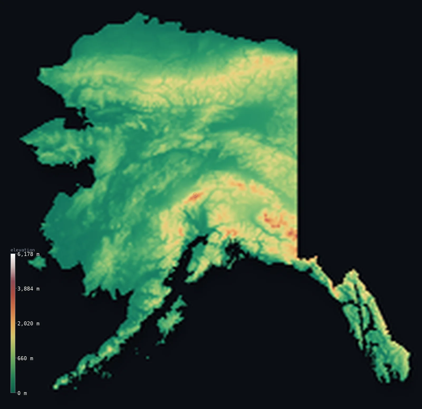
Alaska has Denali — at 20,308 ft (6,190 m), the highest peak in North America — and more named mountains than any other state. By the “tallest and most peaks” test it wins easily. Yet by whole-state ruggedness it ranks only #12 of 50, and by mean elevation #19.
The reason is everything around the peak. Alaska is mostly low, wet tundra and coastal plain — its mean elevation is just 1,496 ft (456 m), and barely 0.4% of it sits above 2,500 m. A single enormous summit doesn’t make a mountainous state; the rest of the ground has to be high too.
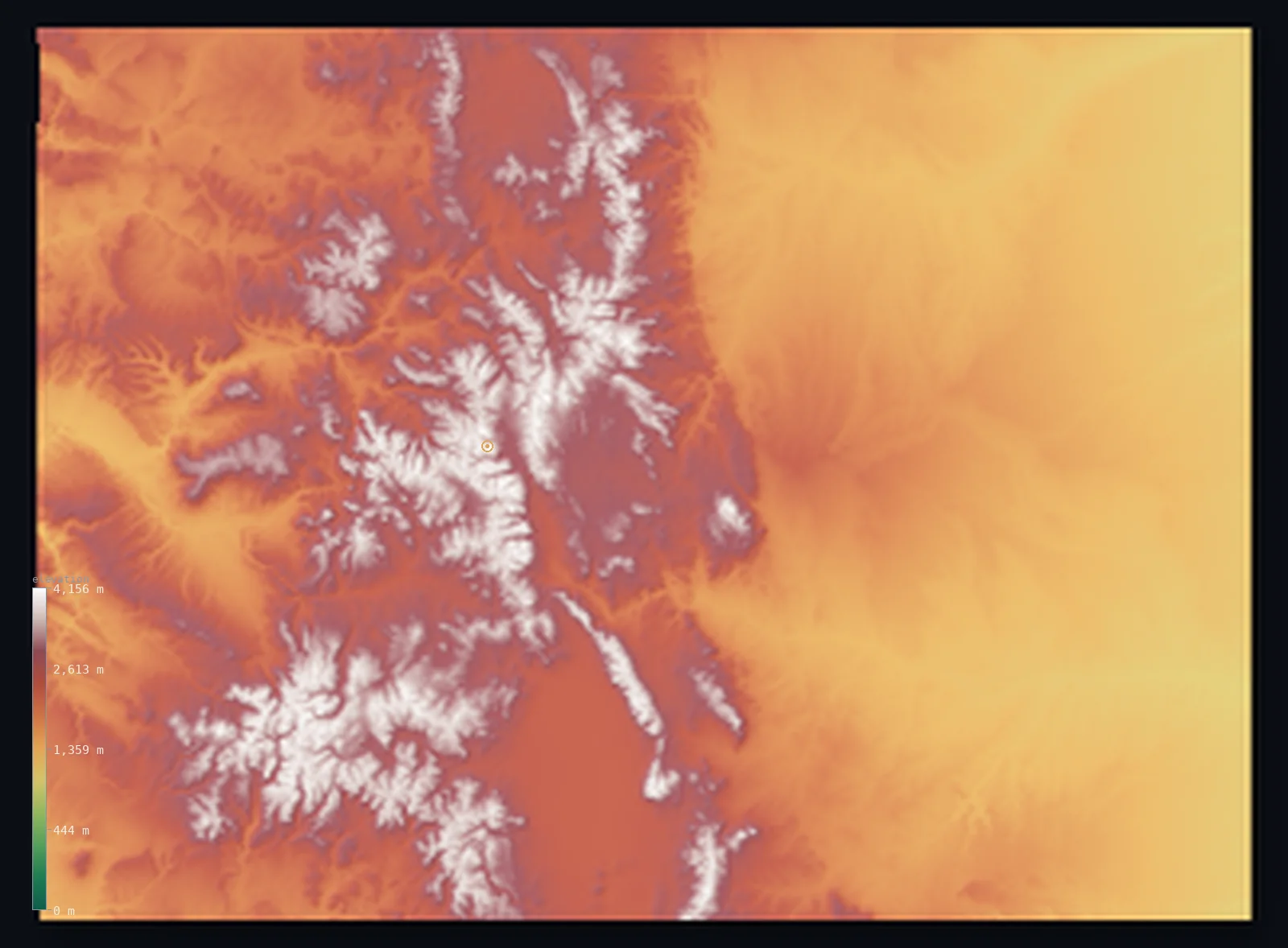
Colorado is the counter-example. Its high point (14,439 ft (4,401 m)) is thousands of feet lower than Denali, but the whole state is elevated — mean 6,867 ft (2,093 m), 29% above 2,500 m — so it out-ranks Alaska on ruggedness (3rd vs 12th) and on mean (1st vs 19th). The tallest peak and the most mountainous state are simply not the same title.
Why the usual rankings disagree
Search “most mountainous states” and no two lists match, because each measures something different. Some rank by mean elevation (which crowns Colorado); some by a single highest peak (which favours Alaska); and some lean on opaque third-party “percent mountainous” datasets whose results don’t survive scrutiny — one popular list ranks Colorado, the roof of the Rockies, 13th.
We don’t use those datasets — they aren’t ours and we can’t trace them. Instead every figure here comes from the same satellite model measured the same way, so the ranking is internally consistent: the Rocky Mountain and Sierra Nevada states land at the top, the coastal plains at the bottom, and nothing needs special pleading. It’s the same first-party method behind our most mountainous countries ranking, applied to the 50 states.
Mountainous isn’t the same as highest
Ruggedness and average height usually agree, but where they part ways is revealing. North Carolina is genuinely rugged — the Blue Ridge and Great Smokies give it a σ that ranks 16th — yet its mean elevation is low (34th), because half the state is flat coastal plain. It is mountainous in part without being high on average.
The opposite case is the elevated plains. Minnesota sits higher on average than its ruggedness suggests (23th by mean, only 41th by σ) — raised but flat, a tableland with almost no relief. A high mean can come from a plateau, not from mountains, which is why measuring the variation matters. Our country ranking found the same split, where a landlocked highland can post a big mean without being rugged.
The least mountainous states
At the flat end sit the coastal plains and the glaciated Midwest. The least mountainous state is Florida (σ 17.8 m), with Delaware and Louisiana close behind — states whose whole surface holds a near-constant height. That end of the scale is its own story: see the flattest states, the exact inverse of this ranking, where Kansas’s pancake reputation gets tested against the data.
Highest state: Colorado. Mean 6,867 ft (2,093 m), with 29% of its land above 2,500 m — more high country than anywhere else.
The Alaska paradox: home to Denali (20,308 ft (6,190 m)), the continent’s tallest peak — yet only #12 most mountainous by whole-state relief.
See any state in 3D
Every state in the table links to its full interactive elevation map — spin Colorado and the whole Rocky Mountain wall stands up; open Alaska and Denali spikes out of low ground, the paradox made visible.
We map the mountain country city by city, too — each with a fine 3D view and its own elevation, from Denver to the high ski towns like Breckenridge. Browse them all on the city elevations hub, or compare states by height on average elevation by state.
Frequently asked questions
- What is the most mountainous state?
- It depends on the measure. By whole-state ruggedness, Hawaii; by mean elevation and the share of high-mountain land, Colorado. Both are defensible — and both rank far above Alaska.
- Is Colorado or Alaska more mountainous?
- Colorado, by any whole-state measure. Alaska has the tallest peak (Denali, 20,308 ft (6,190 m)), but its mean elevation is only 1,496 ft (456 m) and it ranks #12 by ruggedness, versus Colorado at #3.
- Why isn’t Alaska the most mountainous state?
- Because most of it is low. Outside its great ranges, Alaska is vast tundra and coastal plain — a mean of 1,496 ft (456 m) and barely 0.4% above 2,500 m — so a few giant peaks don’t make the whole state mountainous.
- What is the least mountainous state?
- Florida, whose elevation varies by a standard deviation of only 17.8 m — the flattest surface of any state. See the flattest states for the full low-relief ranking.
- How is “mountainousness” measured here?
- By the standard deviation of elevation across the whole state — how much the terrain varies — plus the share of land above 1,500 m and 2,500 m and the mean. All from the same satellite model, so every state is comparable, unlike the mixed methods the popular lists use.
- What’s the most mountainous state to live in?
- If you want to be surrounded by high country every day, Colorado and the Rocky Mountain states — Wyoming, Utah, New Mexico — put the most land at altitude; Hawaii and California offer the sharpest sea-to-summit relief.
Methodology & sources
Elevation is from Copernicus GLO-30 (ESA, 2021 release), clipped to each state’s boundary. Ruggedness σ is the standard deviation of elevation and the high-terrain shares are the fraction of land above 1,500 m and 2,500 m, both computed here from each state’s elevation distribution rather than a third-party “percent mountainous” figure, which we do not use. Because the distribution is binned the figures are approximate; the ranking they produce is robust. State statistics current as of 2026-07-14; same first-party method as the methodology page describes, built by Marko Visic.
Related
- · The flattest states in the US — the exact inverse of this ranking, the same σ measure at the low-relief end.
- · Most mountainous countries — the same method worldwide.
- · Average elevation by state — the 50 states by height, where the Alaska-vs-Colorado gap first shows up.
- · US city elevations — the mountain-west cities in fine 3D.
- · All 50 states by elevation — the full index, each with its interactive map.
Rendered from Copernicus GLO-30 (ESA, 2021 release). Ruggedness measures computed by 3D Elevation Map, 2026-07-14. Built by Marko Visic.