Cities Below Sea Level
Dozens of cities sit below the level of the sea — one by more than 250 metres, a scattering by a metre or two behind a dike. What holds the water back is never the same twice: a tectonic rift, a shrinking inland sea, a wall of pumps, or a desert that drinks the rain before it can pool.
Below is the full list, deepest first, each with the figure that puts it under the tideline and the reason it stays dry. Depths are dual-listed feet-first with an explicit minus, the way an elevation below sea level should be read.
The lowest city on Earth: Jericho
Jericho sits at about −846 ft (−258 m), in the West Bank, near the northern end of the Dead Sea in the Jordan Rift Valley. No other city on Earth is built so low, and by most reckonings none is older: the tell of Tell es-Sultan at its heart holds a stone tower some 11,000 years old, its oldest layers lower still, near −863 ft (−263 m).
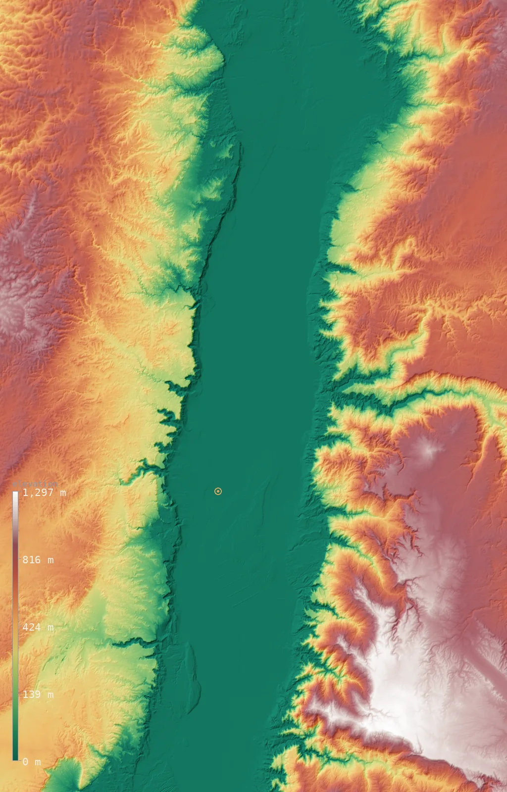
Jericho is low for the reason the Dead Sea is: it lies in the deepest continental rift on the planet, where the crust is pulling apart and dropping. The Jordan River reaches it after descending the whole valley, and the town survives on springs in ground that would otherwise be desert. The 3D map below is the Dead Sea basin itself — Jericho sits at its northern rim.
Every city below sea level, ranked
23 cities and towns, deepest first. Jericho stands more than three times lower than any other; the American entries bunch in a single endorheic basin, and the Dutch and Louisiana entries are the ones held dry by engineering. Population is shown where a settled figure exists.
| City | Country | Below sea level | Population | Why below sea level |
|---|---|---|---|---|
| Jericho | West Bank | −846 ft (−258 m) | ~20k | Jordan Rift Valley (tectonic) |
| Tiberias | Israel | −656 ft (−200 m) | ~48k | Sea of Galilee, Jordan Rift |
| Bet She'an | Israel | −394 ft (−120 m) | ~18k | Jordan Rift Valley (tectonic) |
| Bombay Beach | USA · California | −226 ft (−69 m) | — | Salton Trough (endorheic) |
| Calipatria | USA · California | −180 ft (−55 m) | ~6.5k | Imperial Valley (endorheic) |
| Westmorland | USA · California | −161 ft (−49 m) | — | Imperial Valley (endorheic) |
| Niland | USA · California | −141 ft (−43 m) | — | Imperial Valley (endorheic) |
| Salton City | USA · California | −125 ft (−38 m) | — | Salton Sea shore (endorheic) |
| Brawley | USA · California | −121 ft (−37 m) | ~26k | Imperial Valley (endorheic) |
| Thermal | USA · California | −121 ft (−37 m) | — | Coachella Valley (endorheic) |
| Baku | Azerbaijan | −92 ft (−28 m) | ~2.3M | Caspian coast (closed sea) — largest below sea level; lowest capital |
| Astrakhan | Russia | −92 ft (−28 m) | ~475k | Volga delta, Caspian (closed sea) |
| Coachella | USA · California | −72 ft (−22 m) | ~42k | Coachella Valley (endorheic) |
| Atyrau | Kazakhstan | −66 ft (−20 m) | ~290k | Ural river mouth, Caspian (closed sea) |
| Imperial | USA · California | −59 ft (−18 m) | ~20k | Imperial Valley (endorheic) |
| El Centro | USA · California | −49 ft (−15 m) | ~44k | Imperial Valley — largest US city below sea level |
| Turpan | China | −49 ft (−15 m) | — | Turpan Depression (endorheic desert) |
| Seeley | USA · California | −43 ft (−13 m) | — | Imperial Valley (endorheic) |
| Holtville | USA · California | −39 ft (−12 m) | — | Imperial Valley (endorheic) |
| Rotterdam | Netherlands | −20 ft (−6 m) | ~650k | Polder (pumped, diked) |
| Amsterdam | Netherlands | −7 ft (−2 m) | ~900k | Polder (pumped, diked) |
| New Orleans | USA · Louisiana | −7 ft (−2 m) | ~380k | Delta subsidence + levees |
| The Hague | Netherlands | −3 ft (−1 m) | ~550k | Polder (pumped, diked) |
The Imperial Valley: America’s below-sea towns
Almost every below-sea-level town in the United States sits in one place: the Salton Trough of southern California, a landlocked basin with no drainage to the ocean. The lowest community is Bombay Beach on the Salton Sea, at about −226 ft (−69 m); Calipatria (−180 ft (−55 m)) bills itself as the lowest incorporated city in the Western Hemisphere and flies its flag from a pole tall enough to reach sea level at the tip.
The largest of them is El Centro (−49 ft (−15 m)), the biggest US city below sea level, among a cluster — Brawley, Coachella, Imperial, Westmorland, Holtville — farming land watered by the Colorado River in a valley the sea can never reach. Across the Pacific, Turpan in western China (−49 ft (−15 m)) sits in the same kind of trap: the Turpan Depression, whose floor at Ayding Lake reaches −505 ft (−154 m).
New Orleans: living below the river
The most famous below-sea-level city in America is New Orleans, Louisiana, where roughly half the city lies below sea level and the lowest neighbourhoods sink to about −7 ft (−2 m). Built on subsiding delta mud between the Mississippi River and Lake Pontchartrain, it stays dry behind levees and a constant network of pumps — the vulnerability laid bare when Hurricane Katrina’s surge overtopped the levees in 2005.
The Netherlands: cities on the sea floor
No country lives below the sea like the Netherlands, where about a quarter of the land — and most of the people — sit below the tideline. The cities of the Randstad ride on polders: land pumped dry and held behind dikes. Rotterdam reaches about −20 ft (−6 m), Amsterdam about −7 ft (−2 m), The Hague around −3 ft (−1 m); the deepest ground of all is the Zuidplaspolder, a polder rather than a city, at −23 ft (−7 m).
These are the only cities on the list that are below sea level by design — each a standing bet that the pumps keep running, a bet the Dutch have engineered around for centuries and now re-engineer against a rising North Sea. See the polders as sub-zero terrain in countries below sea level.
Baku and the Caspian: the largest below the sea
The largest city below sea level is Baku, the capital of Azerbaijan — well over two million people on the western shore of the Caspian Sea, whose surface sits about −92 ft (−28 m). The Caspian is the world’s largest inland body of water, cut off from the ocean, and its level has fallen far enough below the global sea to carry its whole coastline down with it. That also makes Baku the world’s lowest-lying capital.
Across the water, Astrakhan in Russia (−92 ft (−28 m)) sits where the Volga fans into its delta, and Atyrau in Kazakhstan (−66 ft (−20 m)) at the mouth of the Ural. None of the three is low by engineering — the sea beside them is simply lower than the ocean the word “sea level” refers to.
Why a city ends up below the sea
Every city here is dry only because something holds the sea out, and it comes in four kinds. A rift drops the ground by tectonics and distance keeps the ocean away — Jericho, Tiberias and Bet She’an in the Jordan Valley. A closed or shrinking sea leaves its own shore below the global ocean — Baku, Astrakhan and Atyrau on the Caspian.
An endorheic basin is a desert hollow with no outlet, where the sun evaporates water faster than rivers deliver it — the Imperial Valley and Turpan. And engineering is the human version: the Dutch polders and New Orleans, low ground reclaimed or defended, dry only as long as the dikes hold and the pumps run. The depth is the same measurement each time; what differs is what keeps the water back. (On why height and depth share one datum, see elevation vs altitude.)
Frequently asked questions
- What is the lowest city in the world?
- Jericho, in the West Bank, at about −846 ft (−258 m) — the lowest, and probably the oldest, city on Earth. It sits in the Jordan Rift Valley, near the Dead Sea.
- What is the lowest city in the US?
- Bombay Beach, California, on the Salton Sea, at about −226 ft (−69 m) is the lowest community; Calipatria (−180 ft (−55 m)) claims the lowest incorporated city, and El Centro (−49 ft (−15 m)) is the largest US city below sea level. All sit in the Imperial Valley.
- Is New Orleans below sea level?
- In large part, yes — roughly half the city lies below sea level, dropping to about −7 ft (−2 m) in the lowest areas, kept dry by levees and pumps between the Mississippi and Lake Pontchartrain.
- What is the largest city below sea level?
- Baku, Azerbaijan, with more than two million people on the Caspian coast at about −92 ft (−28 m) — also the world’s lowest-lying capital. The Caspian Sea’s surface sits below global sea level.
- Are there below-sea-level cities in the Netherlands?
- Many. Most of the Randstad — Rotterdam, Amsterdam, The Hague, Utrecht — sits on polders below sea level, the lowest near Rotterdam around −20 ft (−6 m), kept dry by dikes and pumps.
Sources
City depths are researched lowest-ground figures below sea level, dual-listed with feet from the metres. Jericho’s ~−846 ft (−258 m) and the Dead Sea rift it shares are consistent with our own Israel and Jordan terrain; the 3D basin above renders from Copernicus GLO-30 (ESA). New Orleans, Rotterdam, Amsterdam and The Hague span a range of elevations — the figure is the deepest ground, not a single citywide number. Baku as the largest city below sea level, and as the lowest capital, is by population among sub-zero cities. Populations are shown only where a settled figure exists; several small Imperial Valley towns are left blank rather than estimated. Built by Marko Visic; method on the methodology page.
Related
- · The lowest point on Earth — the Dead Sea, Challenger Deep, and the five deepest land basins in 3D.
- · Countries below sea level — how much of each country lies below 0 m, and the lowest points on land.
- · The highest capital cities — the opposite extreme, cities in the thin air.
- · More elevation deep-dives — the blog.
City elevations are researched lowest-ground figures below sea level; the Dead Sea basin render is from Copernicus GLO-30 (ESA). New Orleans and the Dutch cities span a range (deepest ground shown); populations quoted only where established. Built by Marko Visic.