Map of the Alps
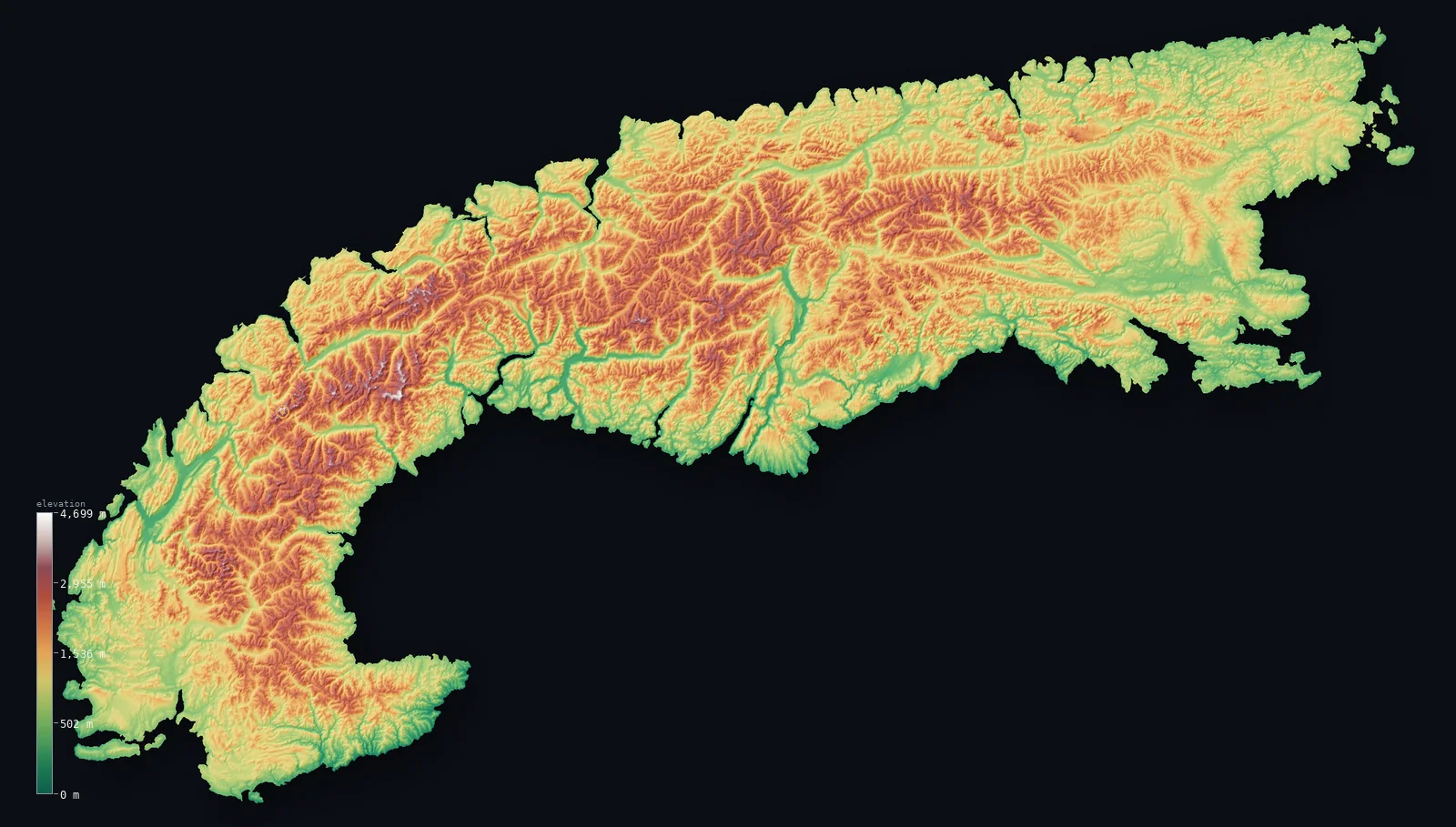
The whole Alps on real terrain, from our satellite elevation model — the full arc masked to the range’s mapped boundary, with 20 of its great peaks pinned (each labelled with its surveyed height). Mont Blanc tops them all at 15,766 ft (4,805.59 m). Drag to spin it (two-finger to orbit on mobile).
Where are the Alps?
The Alps lie across 7 countries. By area the range is dominated by Austria, Italy, France and Switzerland — together about 93% of it — with the remainder in Slovenia, Germany and Liechtenstein. The border foothills clip a few more countries with slivers under a tenth of a percent. Each share below is this page’s own measurement: the range boundary intersected with each country’s outline, by true (geodesic) area.
| Country | Share of range | Area |
|---|---|---|
| Austria | 29.5% | 19,750 mi² (51,152 km²) |
| Italy | 29.1% | 19,446 mi² (50,366 km²) |
| France | 20.2% | 13,499 mi² (34,963 km²) |
| Switzerland | 14.1% | 9,438 mi² (24,445 km²) |
| Slovenia | 4.5% | 3,006 mi² (7,786 km²) |
| Germany | 2.5% | 1,689 mi² (4,374 km²) |
| Liechtenstein | <0.1% | 47 mi² (122 km²) |
| Hungary | <0.1% | 15 mi² (40 km²) |
| Croatia | <0.1% | 3 mi² (8 km²) |
| Monaco | <0.1% | 1 mi² (2 km²) |
Range boundary: GMBA Mountain Inventory v2.0 (standard extent). Country outlines: geoBoundaries ADM0. Computed range area 173,566 km² — within about 1% of GMBA’s published 175,903 km².
The highest peak: Mont Blanc
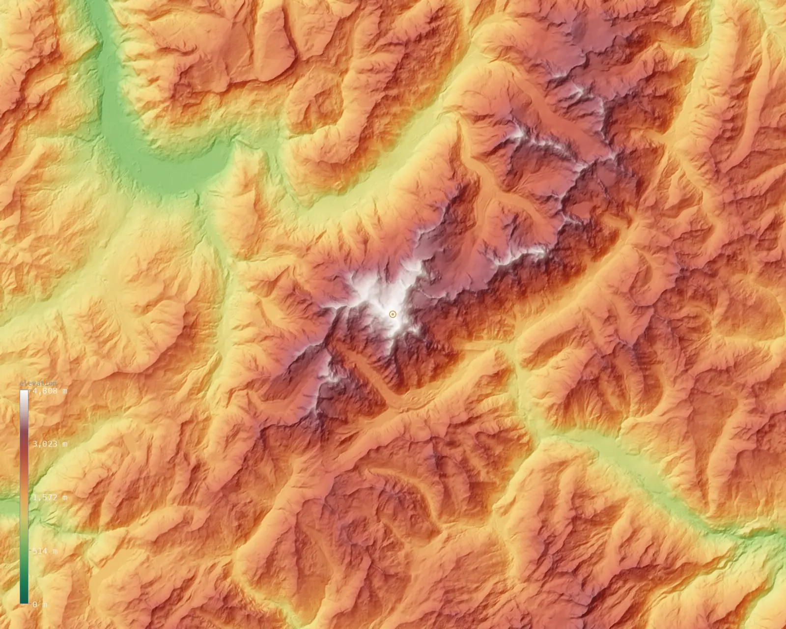
The highest point of the Alps is Mont Blanc, at 15,766 ft (4,805.59 m) (official September 2023 survey (Chambre des Géomètres-Experts de la Haute-Savoie)) — the highest peak in the Alps and the highest in Western Europe. Mont Blanc is re-surveyed every two years each mid-September. Its summit is a snow-and-ice cap — roughly 15 m of ice over rock at about 4,792 m — so the measured height shifts a few metres between surveys.
Zooming to the roof of the range — a fine ~67 m model of the Mont Blanc massif.
Great peaks of the Alps
A curated selection spanning the whole range — the highest 4,000-metre summits together with the high point of each main Alpine country. It is chosen for fame and spread, not by a strict height cutoff, so it includes lower but iconic peaks like Zugspitze and Triglav rather than only the 20 tallest. Each is pinned on the map above; the heights here are the surveyed figures.
| Peak | Elevation | Country | Note |
|---|---|---|---|
| Mont Blanchighest | 15,766 ft (4,805.59 m) | France/Italy | Highest in the Alps (surveyed Sept 2023) |
| Dufourspitze (Monte Rosa) | 15,203 ft (4,634 m) | Switzerland | Highest point in Switzerland |
| Dom | 14,911 ft (4,545 m) | Switzerland | Highest summit wholly within Switzerland |
| Lyskamm | 14,869 ft (4,532 m) | Italy/Switzerland | — |
| Weisshorn | 14,783 ft (4,506 m) | Switzerland | — |
| Matterhorn | 14,692 ft (4,478 m) | Switzerland/Italy | Iconic pyramidal peak |
| Grand Combin | 14,137 ft (4,309 m) | Switzerland | — |
| Finsteraarhorn | 14,022 ft (4,274 m) | Switzerland | Highest of the Bernese Alps |
| Aletschhorn | 13,760 ft (4,194 m) | Switzerland | — |
| Jungfrau | 13,642 ft (4,158 m) | Switzerland | Iconic Bernese Oberland peak |
| Barre des Écrins | 13,458 ft (4,102 m) | France | Southernmost 4,000 m peak in the Alps |
| Gran Paradiso | 13,323 ft (4,061 m) | Italy | Highest peak entirely within Italy |
| Piz Bernina | 13,281 ft (4,048 m) | Switzerland/Italy | Easternmost 4,000 m peak in the Alps |
| Eiger | 13,015 ft (3,967 m) | Switzerland | Famous north face |
| Ortler | 12,812 ft (3,905 m) | Italy | Highest of the Southern Limestone Alps |
| Grossglockner | 12,461 ft (3,798 m) | Austria | Highest in Austria |
| Wildspitze | 12,369 ft (3,770 m) | Austria | Second-highest in Austria (Ötztal Alps) |
| Marmolada (Punta Penia) | 10,968 ft (3,343 m) | Italy | Highest of the Dolomites |
| Zugspitze | 9,718 ft (2,962 m) | Germany | Highest in Germany |
| Triglav | 9,396 ft (2,864 m) | Slovenia | Highest in Slovenia; national symbol |
Relief and elevation range
Across the mapped range the land runs from about 0 ft (0 m) on the valley floors to 15,417 ft (4,699 m) at the highest ground — a vertical range of 15,417 ft (4,699 m), which puts the Alps in the extreme-relief class. The mean elevation is 4,495 ft (1,370 m) and the median 4,147 ft (1,264 m); the two sitting close together says the height is spread broadly across the range, not concentrated in a few peaks over otherwise low ground.
The distribution above is the share of the range’s area at each elevation, computed from the same satellite model as the maps. It reads the Alps as a true massif — a large area held high — rather than a thin crest.
Alps FAQ
- How many countries do the Alps cross?
- The range has a substantial footprint in 7 countries — Austria, Italy, France and Switzerland hold the largest shares, with Slovenia, Germany and Liechtenstein making up most of the rest. A few more countries are clipped by the border foothills with slivers under a tenth of a percent.
- How long are the Alps?
- The Alps arc roughly 1,200 km across Europe, curving from the western end to the eastern foothills. The map above shows that whole arc masked to the range’s mapped boundary.
- How were the Alps formed?
- The Alps were pushed up by the slow collision of the African and Eurasian tectonic plates, a process that folded and stacked former sea-floor and continental rock into the mountain arc that stands today.
- Is Mont Blanc the highest peak in the Alps?
- Yes. Mont Blanc, at 15,766 ft (4,805.59 m), is the highest point anywhere in the Alps — and the highest in Western Europe. The next-highest of the peaks pinned here, Dufourspitze (Monte Rosa), is about 564 ft (172 m) lower.
Related ranges
More of the world’s mountains, rendered the same way — explore other ranges in 3D.
- Dolomites↑ Marmolada, 10,968 ft (3,343 m)
- Pyrenees↑ Aneto, 11,168 ft (3,404 m)
- Atlas Mountains↑ Toubkal, 13,671 ft (4,167 m)
- Himalayas↑ Mount Everest, 29,032 ft (8,848.86 m)
- Rockies↑ Mount Elbert, 14,439 ft (4,401 m)
- Andes↑ Aconcagua, 22,838 ft (6,961 m)
Elevation from Copernicus GLO-30 (ESA), sampled over the range and masked to its boundary. The range boundary is the GMBA Mountain Inventory v2.0 (standard extent; Snethlage et al. 2022, CC BY 4.0). Country outlines from geoBoundaries. Every figure on this page is computed from these sources; the surveyed Mont Blanc height is the one exception, cited above. See the methodology. Data as of 2026-08-21.