Map of the Appalachians
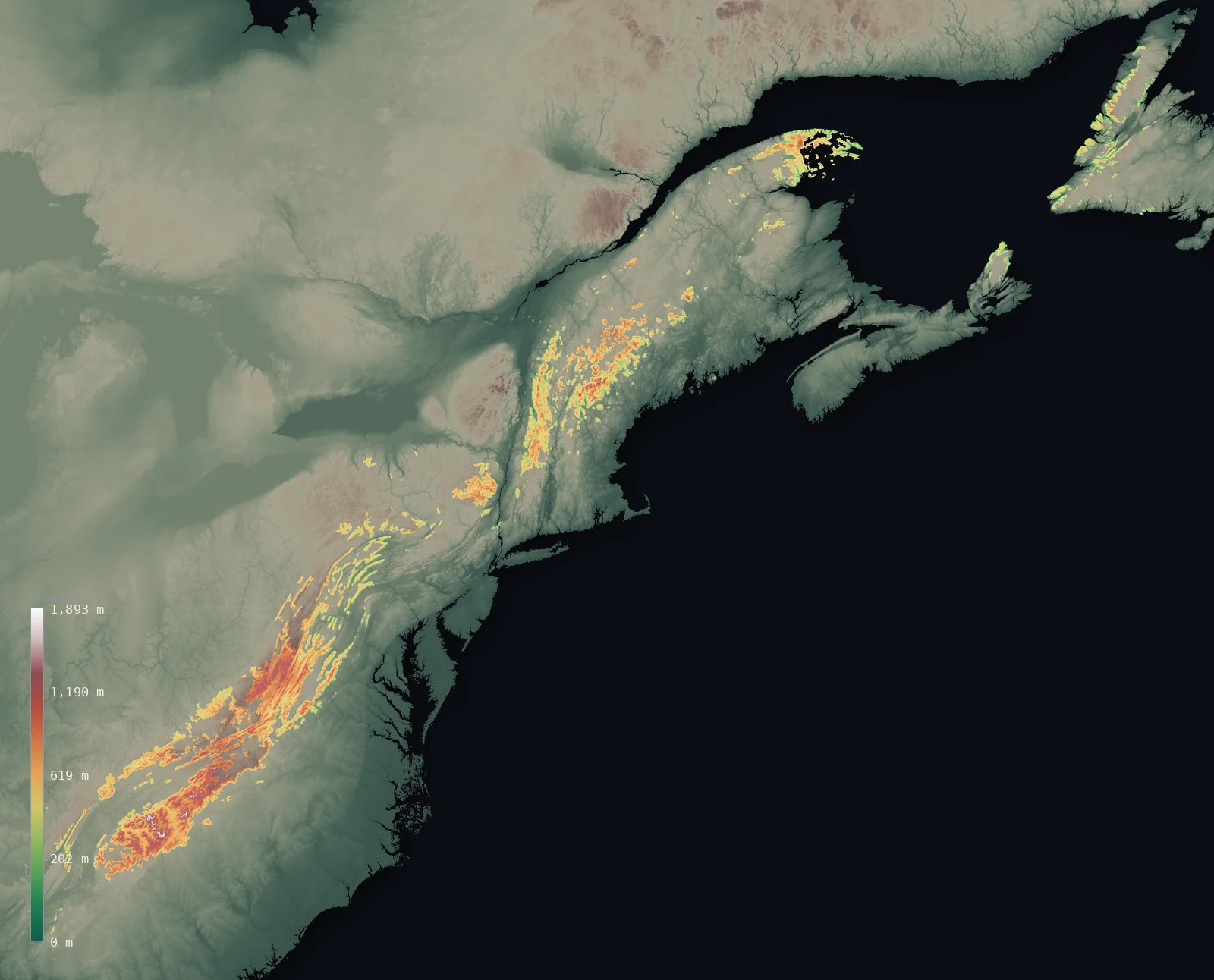
The whole Appalachians on real terrain, from our satellite elevation model — the full arc masked to the range’s mapped boundary, with 8 of its great peaks pinned (each labelled with its surveyed height). Mount Mitchell tops them all at 6,683 ft (2,037 m). Drag to spin it (two-finger to orbit on mobile).
Where are the Appalachians?
The Appalachians lie across 2 countries. By area the range is dominated by the United States and Canada — together about 100% of it. Each share below is this page’s own measurement: the range boundary intersected with each country’s outline, by true (geodesic) area.
| Country | Share of range | Area |
|---|---|---|
| United States | 85.4% | 42,690 mi² (110,567 km²) |
| Canada | 14.6% | 7,313 mi² (18,939 km²) |
Range boundary: GMBA Mountain Inventory v2.0 (standard extent). Country outlines: geoBoundaries ADM0. Computed range area 129,637 km² — within about 1% of GMBA’s published 129,875 km².
The highest peak: Mount Mitchell
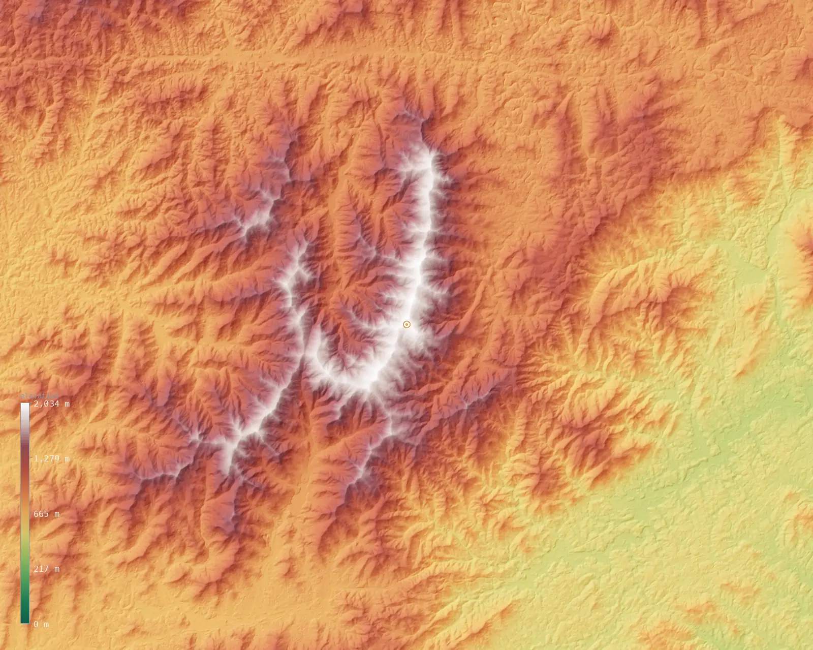
The highest point of the Appalachians is Mount Mitchell, at 6,683 ft (2,037 m) — the highest peak of the Appalachians and the highest east of the Mississippi River.
Zooming to the roof of the range — a fine ~62 m model of the Mount Mitchell massif.
Great peaks of the Appalachians
A curated selection — the range's highest summits and regional high points along its length, chosen for fame and spread rather than by a strict height cutoff. Each is pinned on the map above; the heights here are the surveyed figures.
| Peak | Elevation | Country | Note |
|---|---|---|---|
| Mount Mitchellhighest | 6,683 ft (2,037 m) | Yancey Co., North Carolina | Highest peak of the Appalachians and east of the Mississippi |
| Kuwohi (Clingmans Dome) | 6,644 ft (2,025 m) | Tennessee / North Carolina | Highest in Tennessee, the Smokies, and on the Appalachian Trail |
| Mount Washington | 6,289 ft (1,917 m) | Coös Co., New Hampshire | Highest in the Northeast; famed for extreme weather |
| Mount Rogers | 5,728 ft (1,746 m) | Grayson/Smyth Co., Virginia | Highest point in Virginia |
| Katahdin | 5,269 ft (1,606 m) | Piscataquis Co., Maine | Highest in Maine; northern terminus of the Appalachian Trail |
| Spruce Knob | 4,862 ft (1,482 m) | Pendleton Co., West Virginia | Highest point in West Virginia and the Alleghenies |
| Brasstown Bald | 4,783 ft (1,458 m) | Towns/Union Co., Georgia | Highest point in Georgia |
| Mont Jacques-Cartier | 4,160 ft (1,268 m) | Quebec, Canada | Highest in the Canadian Appalachians (Chic-Chocs) |
Relief and elevation range
Across the mapped range the land runs from about 0 ft (0 m) on the valley floors to 6,211 ft (1,893 m) at the highest ground — a vertical range of 6,211 ft (1,893 m), which puts the Appalachians in the moderate-relief class. The mean elevation is 2,034 ft (620 m) and the median 1,916 ft (584 m); the two sitting close together says the height is spread broadly across the range, not concentrated in a few peaks over otherwise low ground.
The distribution above is the share of the range’s area at each elevation, computed from the same satellite model as the maps. It reads the Appalachians as a true massif — a large area held high — rather than a thin crest.
Appalachians FAQ
- How many countries do the Appalachians cross?
- The range has a substantial footprint in 2 countries — the United States and Canada hold the largest shares.
- How long are the Appalachians?
- The Appalachians arc roughly 3,200 km along eastern North America, from Alabama and Georgia north into Quebec and Atlantic Canada. The map above shows that whole arc masked to the range’s mapped boundary.
- How were the Appalachians formed?
- The Appalachians are among Earth's oldest mountains — thrown up by a series of ancient continental collisions hundreds of millions of years ago and worn down by erosion ever since.
- Is Mount Mitchell the highest peak in the Appalachians?
- Yes. Mount Mitchell, at 6,683 ft (2,037 m), is the highest point anywhere in the Appalachians. The next-highest of the peaks pinned here, Kuwohi (Clingmans Dome), is about 39 ft (12 m) lower.
Related ranges
More of the world’s mountains, rendered the same way — explore other ranges in 3D.
- Blue Ridge Mountains↑ Mount Mitchell, 6,683 ft (2,037 m)
- Great Smoky Mountains↑ Kuwohi (Clingmans Dome), 6,644 ft (2,025 m)
- Adirondacks↑ Mount Marcy, 5,344 ft (1,629 m)
- White Mountains↑ Mount Washington, 6,289 ft (1,917 m)
- Catskills↑ Slide Mountain, 4,180 ft (1,274 m)
- Ozarks↑ Turner Ward Knob, 2,454 ft (748 m)
Elevation from Copernicus GLO-30 (ESA), sampled over the range and masked to its boundary. The range boundary is the GMBA Mountain Inventory v2.0 (standard extent; Snethlage et al. 2022, CC BY 4.0). Country outlines from geoBoundaries. Every figure on this page is computed from these sources; the surveyed Mount Mitchell height is the one exception, cited above. See the methodology. Data as of 2026-08-22.